Places We Protect

Brownsville Preserve

Virginia

Bridge over Upshur Creek at Brownsville Preserve. A wooden foot bridge extends over the marsh and shallow water of Upshur Creek on Virginia's Eastern Shore.
Upshur Creek Visit Brownsville Preserve. Explore wooded uplands, take in expansive marsh views and enjoy the variety of life all around you. © Margaret Van Clief

Explore the Volgenau Virginia Coast Reserve through this gateway preserve.

Overview

Description

Birds and other wildlife abound at Brownsville Preserve. From the boardwalk and trails traversing this historic farm, you may see deer, fox, raccoons, blue herons, bald eagles, wild turkeys and many other species of birds.

Until TNC purchased Brownsville in 1978, the farm had remained in the Upshur family since 1652. The historic Brownsville House dates to 1803 and continues to welcome neighbors and guests during VVCR's annual Holiday Open House and Open Farm events.

TNC manages Brownsville to enhance bird habitat, and the farm serves as headquarters for the Volgenau Virginia Coast Reserve. Learn more about our land protection, migratory bird and marine habitat restoration work as well as our education and community outreach programs.

Access

OPEN TO THE PUBLIC

Leashed dogs are permitted on the William B. Cummings Birding & Wildlife Trail only.

Hours

Daily ½ hour before sunrise to ½ hour after sunset.

For visitor safety during the deer hunting season (October through early January), preserve hours are 9:00 a.m. to 3:00 p.m. 

Highlights

Birding, Biking, Nature Trails, Nature Photography, Geocaching, Self-Guided Audio Tour

Leashed dogs are permitted on the William B. Cummings Birding and Wildlife Trail. Dogs on the trail must be leashed at all times

Dogs are not allowed on any of the Volgenau Virginia Coast Reserve islands.

Size

1,250 acres

Explore our work in Virginia

Brownsville Preserve

A visit to Brownsville Preserve affords opportunities to explore wooded uplands, take in expansive marsh views and enjoy the variety of life all around you.

Families seated in a large open sided wagon for a tour of Brownsville Preserve.
A group of people stand around a collection of kayaks.
A ground of people walk along a trail as the sun sets behind a line of trees along the horizon.
Three people with cameras photograph an unsee animal in the tall grass.
Holiday tree decorated with shells and gingerbread cookies.

Visit

  • The William B. Cummings Birding and Wildlife Trail offers a round-trip hike of three miles through memorable coastal Virginia scenery. Explore wooded uplands, take in expansive marsh views and enjoy the variety of life all around you.

    Numbers on the trail map correspond with markers along the trail. Refer to the trail guide for information on these points of interest.

    Bring your binoculars, field guides and a camera. Especially in warm weather, don't forget insect and tick repellent!

  • Geocaching is a fast-growing hobby that provides an exciting way to explore the outdoors. Players try to locate hidden containers, called geocaches, using a smartphone or GPS, and can then share their experiences online.  It's a great way for kids to connect with nature and learn navigation skills, with the fun reward of finding real hidden treasure.

    We invite you to explore TNC's natural areas in this fun and free way. It's a great hobby, and you may learn a little about our work as you play!

    GEOCACHES AT BROWNSVILLE PRESERVE

    Log on to www.geocaching.com to set up a free account.  


     KNOW BEFORE YOU GO

    • Caches are only accessible during normal hours of operation.
    • Stay on marked trails at all times.
    • Do not litter; used marked receptacles to dispose of any trash.
    • Please respect the land; do not remove plants, animals, artifacts or rocks.

    New geocaches are not permitted on TNC preserves. These sites were carefully selected for their accessibility and low impact to the environment. For questions about geocaching at Brownsville Preserve, please contact Margaret Van Clief, Outreach and Education Coordinator, at mvanclief@tnc.org.

  • Please help us protect this area by observing these guidelines:

    • Leashed dogs are permitted on the William B. Cummings Birding and Wildlife Trail ONLY
    • Dogs on the trail must be leashed at all times
    • Dogs are not allowed on any of the Volgenau Virginia Coast Reserve islands
    • Bike are permitted at Brownsville
    • Please hike or bike only on the designated marked trail and respect the areas marked private or no trespassing
    • No horseback riding. No ATVs.
    • Preserve closes at 1/2 hour after sunset, daily. For safety during the deer hunting season, visitor hours at 9:00 a.m. to 3:00 p.m. (October through early January)

    You may also wish to combine your visit to Brownsville with other Eastern Shore sites on the Virginia Birding and Wildlife Trail.

Self Guided Audio Tours

Explore Brownsville with a self-guided audio tour on your handheld device. It's like having a naturalist in your pocket! Tours are offered in both English and Spanish with written transcripts available for each of the twelve stops.

The numbers marked on the map correspond to the audio files in the self-guided tour.  Play the corresponding track when you reach a waypoint along the trail. Listen to them all or pick and choose based on your interests!

English Language Audio Tour

Begin your journey: download the audio tour map (pdf)

Meet Your Guides

  • Beverly Watson is a native of the Nassawadox area where Brownsville Preserve is located. Beverly retired from TNC in 2017, after working as Brownsville's office manager for more than 15 years. She found it gratifying to be a small part of ongoing projects and programs to conserve the natural resources on the Eastern Shore of Virginia that is so well loved by so many people. 

  • Joanne Laskowski started her career as an Environmental Educator and went on to receive a Master's degree in Ecology from Rutgers University with an emphasis on Ornithology. She retired from Talbot County Public Schools after 22 years as the Science Supervisor and 1-1 Laptop Coordinator. Currently she conducts piping plover surveys for Chincoteague NWR and TNC and coordinates the Eastern Shore Master Naturalist Basic Training class under Dot Field. 

  • Charlottesville native Margaret Van Clief ;moved to the Eastern Shore of Virginia in 2008 and soon developed a devotion to the natural gifts of the Shore as strong as her love of the people. As VVCR's Outreach & Education Coordinator, Margaret works in the community to connect residents and Eastern Shore visitors with VVCR’s properties through public events and educational programming, both on and off the preserve. 

  • Heather Eggleston has a Bachelor’s of Science Degree in Environmental Studies and tons of life experience gallivanting in the natural world. She worked for three years as a seasonal technician for TNC. In 2015 she was the Marine Technician at the Volgenau Virginia Coast Reserve. She enjoys spending long periods of time in the woods and photographing unusual mushrooms.  

  • Frederick, MD native Victor Klein moved to the Eastern Shore in 2012. He completed a Master Naturalist course in 2014 and is an avid birder.

Audio Tour - English

  • Download the audio file (.mp3)

    I’m Beverly Watson and I grew up in this area, and I’ve been the office manager at the Virginia Coast Reserve for several years. Welcome to the William B. Cummings Birding and Wildlife Trail at Brownsville, the headquarters of The Nature Conservancy’s Virginia Coast Reserve. The Brownsville Farm is a 1,250-acre parcel of land near the town of Nassawadox. The Nature Conservancy purchased this farm in 1978 from the Upshur family who had owned it, and lived there, since 1652.

    Among the reasons Brownsville was chosen is that one of the few deep-water creeks on the seaside runs right along the property. It has a dock providing consistent access for researchers and other TNC staff to get out to the Virginia(‘s) Barrier Islands. The Nature Conservancy owns and protects 14 of the 18 barrier islands.

    As you walk the trail, you will see other reasons why this farm was chosen. The variety of habitats you will pass through in three short miles house all manners of plants, birds, and other wildlife. And also, during the summer season, you’ll find the orchids growing in marshes.

    It is The Nature Conservancy’s pleasure to invite you to join us in marveling at the nature of Virginia’s beautiful Eastern Shore.

    Parking is available at the trailhead, with additional parking at the office nearby.

    The trail is open daily from a half-hour before sunrise to a half-hour after sunset, with the exception of October-January, when it is open from 9:00 AM to 3:00 PM.

    Dogs are allowed on the trail, but for the safety and comfort of wildlife and guests, please do keep them on a leash at all times.

    You can have many bugs on the trail, just be sure to bring your bug spray.

    Enjoy your walk.

  • Download the audio file (.mp3)

    Hi, I’m Joanne. I am an Eastern Shore Master Naturalist for the state of Virginia. I also volunteer for The Nature Conservancy doing Piping Plover and American Oystercatcher bird surveys on the Virginia Coastal Reserve.

    We have reached the end of the boardwalk and we will see the road leading off to the right. This is a natural area in ecological succession.

    As you stand in this area, notice that many of the trees around you are dying. You will see Red Cedar trees and old Loblolly Pines with pinecones at the top. And one of the reasons these trees are beginning to die is because of saltwater intrusion. And the way that you know that saltwater intrusion is coming in is you see this fine green grass carpeting the floor—and this is known as Spartina patens, or salt marsh hay. Kind of does look like hay, except it’s green!

    Salt marsh hay is what is typically found in areas that get inundated by saltwater only occasionally, at times such as full moons or during storms, which push water up along the Virginia creeks.

  • Download the audio file (.mp3)

    My name is Margaret Van Clief, I’m the Outreach and Education Coordinator for The Nature Conservancy’s Virginia Coast Reserve. Previously, I’ve worked on our seaside oyster restoration project on the barrier islands, as well as leading eco-kayak tours around the Eastern Shore.

    Standing here, looking at this trumpet vine—which is the large, woody, light-colored vine creeping up the loblolly pine in front of you—you may see that it has long, tubular, orange blossoms that look very much like a trumpet. This vine has probably been growing here since the 1960s, and they can live quite a deal longer than that, and it may creep even further up the tree, though probably not much further.

    The trumpet vine has a fantastic symbiotic relationship with the Ruby-throated Hummingbird, which has a beak that is perfectly suited for reaching into the long, orange, trumpet-like blossoms. And as it goes into the blossoms and feeds on the nectar within, a little bit of pollen will shake off onto its head. And then, as it pops along and goes from blossom to blossom, it helps to fertilize the vine as well, thus ensuring that they may hopefully have a nice, long life.

    Both of these are Eastern Shore natives and something that you will see throughout the trail.

  • Download the audio file (.mp3)

    As you stroll through the upland forest, you will see a variety of pines and hardwoods. If you look to your left, you will see many small loblolly pines starting to grow very thick, and they have feathery green needles.

    One of the reasons for the little pines growing in this area is they are getting a lot of sun—they need that to be able to sprout. So, if you look up, you notice that the canopy—the larger trees—are not shading out the tiny little loblollies.

    On the right, you notice a forest floor with very little undergrowth, and the reason for that is because of the shade from the large canopy trees. Now, this provides different niches for different animal species.

    For birds, you may find the Pine warbler up in the top of the canopy, because that’s where it likes to feed. On the forest floor, you might find the Ovenbird, another species of warbler that actually builds its nest on the floor, and it looks just like an oven, thus its name.

  • Download the audio file (.mp3)

    My name is Heather, and I am the seasonal marine technician at The Nature Conservancy. I spend a lot of time out on boats monitoring oyster reefs, collecting eelgrass, and then spreading eelgrass throughout the bays.

    As you walk out of the forest into this beautiful clearing, you might notice that there is a difference in vegetation from the left to the right sides of the road. And there is! There’s more Narrowleaf cattail, there’s some happier trees off in the distance; on the right you’ll notice there’s some salt marsh hay.

    The reason that the vegetation on each side of the road is different is because there’s more saltwater inundation happening on the right side of the road than there is on the left. You’ll see many grasses that are commonly found in the salt marshes of the Eastern Shore all around, and closest to the trail is salt meadow cordgrass, also called salt meadow hay because of its fine texture.

    In the last century, farmers would put their livestock out into these salt meadow areas, the livestock would eat the hay, and that’s why it’s called salt meadow hay.

    Red-winged blackbirds nest among the Narrowleaf and Common cattails here. And in the summer, there are countless swamp rose-mallow, or marsh hibiscus plants, blooming throughout.

  • Download the audio file (.mp3)

    As you walk down the road toward the bare trees at the end, keep an eye out for small mammals that may skitter across in front of you. Maybe you’ll see a Fowler’s toad hopping out of the way, perhaps a little quail will run out of the underbrush.

    The fields on your left, which once held a variety of crops, but they’ve now been restored by The Nature Conservancy with native grasses and rushes, and they provide food, and shelter, and other benefit, while keeping the fields open for us, so we may enjoy a darting dragonfly, or, perhaps you’ll see an American goldfinch foraging among the grasses.

    And then as you look to your right, you’ll see that trumpet vine and greenbrier are all over the place, and it looks like a crazy mess. But, if you look at it from the point of view of a little quail hiding from a hungry, immature bald eagle, or a rabbit making a den, it’s a wonderful shelter and a vital one.

    These dense thickets, which are created by the greenbrier with its tough, thorny stems and its large and leathery leaves, are perfect for providing cover for all kinds of creatures. The grey catbird will build its nest among these vines, and occasionally, so will the cedar waxwing. And the greenbrier’s berries stay on the vine all winter long, and they feed all kinds of animals—from opossums to even a wood duck in a fix.

  • Download the audio file (.mp3)

    My name is Victor Klein, I’m a Master Naturalist in training for the Eastern Shore of Virginia.

    Following the bend in the road, we come to a spot where there’s snags on the right and the meadow is on the left. Nature never misses an opportunity, and the area of snags—or dead trees—ahead of you is no exception.

    In 2003, when Hurricane Isabel hit, the water table rose so high, and stayed high for so long, that the salt choked out many plants—including this strand of mature pines. Now, with the canopy no longer soaking up sun, new plants and trees are growing up among their fallen predecessors.

    Insects have begun making their homes in the dead trees, and we know what follows that: woodpeckers.

    Tall snags also make excellent hunting and nesting spots for osprey, and great horned owls will sometimes occupy their cavities, though they prefer to take over another bird’s nest entirely.

    Marsh rose—a favorite of certain types of solitary bee, another species that enjoys building its nest in snags—grows rather prolifically among the blackberry bushes here.

    Take a moment to look at the trees along the road—does it look like someone has been chewing up on them? Are any of them rolled up, or folded over in an unusual way? The culprit is likely an insect, having its dinner or building its nest. Look closer and you may find it.

    It’s amazing, the things you see when you stand still in nature for a moment.

  • Download the audio file (.mp3)

    As you leave the grassland behind, you will notice on your left that there is a rectangular body of water. You’ll also notice a water control structure—the metal box—right at the edge of the road.

    This water control structure is used to manage water in the rectangular basin for wading birds, such as herons, egrets, and ibis, which fish here and roost on the dead trees that are laying across the water. Be sure to check them for turtles as well.

    (If) when you continue up the path about 50 feet, you will notice on your right that there is a propane tank, and it is used in the water management program during different seasons of the year.

  • Download the audio file (.mp3)

    Take a break in the screen house!

    Spring through fall, the meadow in front of the screen house, and the path past the old, overgrown, tenant house, are great places to watch butterflies flit and dragonflies feed. In fact, it’s a good spot for observing all types of insects and spiders.

    Look for the black saddlebag dragonfly as it hunts in flight for other insects. Observe how the large, black patches on its wings, with the saddlebags, cause its body to look much larger than it is.

    Butterflies have adaptations that play tricks on their predators as well. Find a little common buckeye and see how the several eyespots on its wings make it look like a threatening predator itself.

    While you’re caught up in the world of insects, be careful not to stumble upon one of the many Canada geese who tend to graze in this little field! In the spring, you may even see a gosling.

  • Download the audio file (.mp3)

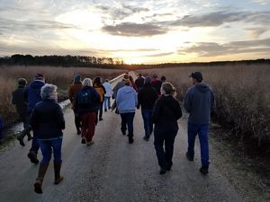
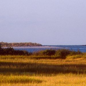
    From this observation deck, looking across the marsh towards Hog and Parramore islands in the distance, you can get a real feel for the human history on Brownsville Farm. It’s hard to imagine, but cows once grazed the salt meadow, and the cedar fence posts you see in front of you and to the left are evidence of that.

    You can see from some of the salt marsh grass that’s around us that saltwater does rise this high, otherwise it wouldn’t be able to grow, but at a low tide, it can be mostly dry and mud.

    To the southeast—off to the right a bit—is a hummock, an island in the marsh, where centuries ago, Native Americans discarded their empty clam and scallop shells in neat stacks along the bank.

    To the far south—off to your right—lie the remains of the old causeway that connected the farm to the hummock, but storms and extreme tides have pulled it apart.

    If you stay here long enough, you’re likely to see more than one great egret stalking crabs in the marsh, maybe even a green heron or possibly a little blue (heron).

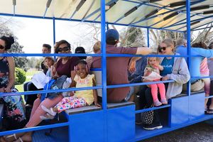
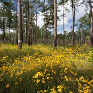
    Standing at this point and taking in this view, it’s not hard to see why The Nature Conservancy works so hard to protect places like this for generations to come.

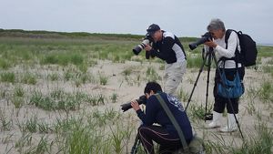
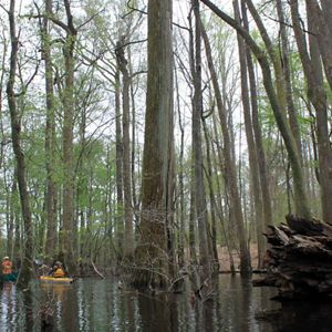
    As you walk along the trail—and at this point in particular—you’ll see occasional manmade things like PVC pipes sticking up, that look like they may not belong. Brownsville Farm, while being a beautiful habitat preserved by The Nature Conservancy, is also a working scientific research area, and many scientists, grad students, and other researchers will come here to study local flora and fauna, salinity levels, sea level rise—any number of things. So, as you walk along the trail, if you see something that looks like it may be a scientific experiment, it probably is!

  • Download the audio file (.mp3)

    Once you are finished at the observation deck, walk toward the screened porch again, and then continue to walk past the solar panels and you will see an impoundment on your left. Impoundments on Brownsville Farm harken back to the days when they were built to attract ducks and geese to be hunted.

    Now, with the help of a solar pump and a well, The Nature Conservancy is able to manage the water levels in a way that will attract a broad variety of birds.

    In the springtime, you may see lesser yellowlegs, glossy ibis, and other egrets and herons feeding in the shallow water, or tree swallows swooping about, hunting mosquitos that hatch in the ponds.

    In the fall, ducks and geese will stop here for a rest or to feed, with little memory of their cousins who were once hunted here.

  • Download the audio file (.mp3)

    The last stop on our walk is this view of Phillips Creek. From this point, you can get a good look at the high marsh, with its shrubs and low, salt-tolerant trees, and the low marsh, with its mud flats and salt marsh cordgrass.

    In the winter, though you may not be able to see them, the mud flats are filled with burrowed fiddler crabs, waiting out the weather.

    In the warmer months, you’ll know they’re there as the banks seem to come alive with swarms of these crabs, sifting through the mud for particles of food, and males brandishing their large claws to attract mates and ward off competition. Wait long enough for a herring gull, or any other perceived threat to come by, and you’ll see them scatter.

    Waiting birds like the green heron and snowy egret fish here on the flats, and diving birds like the Common Loon come here to hunt and fish at higher tides.

    Here at Phillips Creek, we have reached the end of our trail. Simple retrace your path to return to the trailhead, and enjoy your walk back.

    Thank you for visiting The Nature Conservancy’s Brownsville Preserve, we hope you’ll come back soon.

Audioguía En Español

Comience su viaje: descargar el mapa del audioguía de la granja Brownsville (pdf)

Conoce a tu Guía

Claudia Moncada es la pasante de divulgación y conservación en español del verano 2022 para la Reserva de la Costa de Virginia Volgenau de The Nature Conservancy. Ella tiene un título de Ciencias Marinas de la Universidad de Carolina del Sur y está estudiando para un título de maestría de Ciencias Marinas del Instituto de Ciencias Marinas de Virginia. Ella está interesada en comunicación científica bilingüe y en compartiendo las maravillas de la naturaleza con gente de todas edades a través de educación informal y los cuentos.


Claudia Moncada is the summer 2022 Spanish Language Conservation Outreach Intern for TNC's Volgenau Virginia Coast Reserve. She has a bachelor’s degree in Marine Science from the University of South Carolina and is currently pursuing a master’s degree in Marine Science from the Virginia Institute of Marine Science. She is interested in bilingual science communication and sharing the wonders of nature with folks of all ages through informal education and storytelling.

Audioguía - En Español

  • Descargar disponible en Español (mp3)

    Hola, mi nombre es Claudia Moncada y yo soy la pasante de divulgación y conservación en español para The Nature Conservancy.

    Bienvenidos a la senda de observación de aves y vida silvestre de William B. Cummings en Brownsville, la sede de la reserva de la costa de Virginia Volgenau de The Nature Conservancy (TNC). La granja Brownsville es un terreno de 1.250 acres en la ciudad de Nassawadox. The Nature Conservancy lo compró en el año 1978 de la familia Upshur, que trabajó y vivió aquí desde el año 1652.

    Una de las razones por las cuales se escogió la granja Brownsville es que uno de los poquísimos arroyos profundos del lado marítimo corre al lado del terreno. También tiene un muelle que le da acceso consistente a las islas barreras de Virginia a los investigadores y otros trabajadores de TNC. The Nature Conservancy posee y protege 14 de las 18 islas barreras de Virginia.

    Mientras pasea por la senda, usted verá otras razones por las cuales se escogió esta granja. Las variedades de hábitat por las cuales pasará en estas tres cortas millas contienen cualquier variedad de plantas, aves y otros animales silvestres. También verá que, durante la temporada del verano, crecen orquídeas en la marisma.

    Es el placer de The Nature Conservancy invitarles a acompañarnos a disfrutar la naturaleza de la costa oriental de Virginia.

    Se puede parquear al principio de la senda y hay parqueo adicional en la oficina que está cerca.

    La senda está abierta desde media hora antes de la salida del sol hasta media hora después de la caída del sol, exceptuando durante los meses de octubre hasta enero, cuando está abierta desde las 9 de la mañana hasta las 3 de la tarde.

    Se permiten perros, pero por la seguridad y comodidad de los animales silvestres y visitantes, por favor manténgalos con correa a todos momentos.

    Puede haber muchos insectos en la senda, entonces no se olvide de su repelente de insectos.

    ¡Disfrute de su paseo!

  • Descargar disponible en Español (mp3)

    Hemos llegado al fin del malecón y aquí verá el camino que continúa a la derecha. Esta es un área que está en sucesión ecológica.

    Mientras se para en esta área, notará que muchos de los árboles a sus alrededores se están muriendo. Verá los árboles de cedro rojo y pinos loblolly con piñas en sus copas. Unas de las razones porque estos árboles se están muriendo es dada a la intrusión de agua salada. Una manera de estar seguro que es intrusión de agua salada es que se ve una hierba verde y muy fina cubriendo el suelo—esto se conoce como Spartina patens, o heno de marisma. De verdad parece heno, ¡pero es demasiado verde!

    El heno de marisma se encuentra en lugares donde entra el agua salada e inunda el área ocasionalmente, por ejemplo, cuando hay luna llena o cuando pasa una tormenta fuerte y el agua se empuja a través de los arroyos de Virginia. 

  • Descargar disponible en Español (mp3)

    Parándose aquí y mirando a esta enredadera trompeta—que es la enredadera grande y leñosa de color pálido que está creciendo sobre este pino loblolly en frente de usted—se puede ver que tiene flores largas y tubulares de color naranja que se parecen mucho a una trompeta. Esta enredadera probablemente ha estado creciendo aquí desde los años 1960 y pueden vivir mucho más que eso. Es posible que siga creciendo más hacia arriba pero no es probable que crezca mucho más.

    La enredadera trompeta tiene una relación simbiótica fantástica con el colibrí garganta rubí, que tiene un pico perfecto para comer de las flores largas y anaranjadas. Cuando el colibrí mete su cabeza en las flores para comer del néctar, un poco del polen le cae encima. Después, cuando vuela de flor en flor, ayudará a que la enredadera sea fertilizada y asegurará de que la enredadera y el colibrí tendrán los dos vidas largas y felices.

    Los dos son nativos de la costa oriental de Virginia y los verá por toda la senda.

  • Descargar disponible en Español (mp3)

    Mientras pasea por las tierras altas boscosas, usted notará una variedad de pinos y árboles de madera dura. Si mira a su izquierda, verá muchos pinos loblolly pequeños que están empezando a crecer muy juntos unos a otros y que tienen hojas verdes y plumosas.

    Una de las razones porque los pinitos están creciendo aquí es porque están expuestos al sol, algo que necesitan para que puedan empezar a crecer. Si mira hacia arriba, notará que el dosel arbóreo, o los árboles más grandes, no le está dando demasiada sombra a los pinitos loblolly como para que se mueran.

    A la derecha, verá que el suelo tiene muy poco sotobosque. La razón por esto es dada a la sombra que proporcionan los árboles altos del dosel. Esto también proporciona muchos nichos ecológicos para muchas especies de animales.

    Se pueden encontrar reinitas del pinar en las partes altas del dosel arbóreo porque allí es donde les gusta comer. En el suelo del bosque se pueden encontrar reinitas horneras que construyen sus nidos en el suelo que parecen hornitos—por eso se llaman así.

  • Descargar disponible en Español (mp3)

    Al salir del bosque y entrar a este bello claro, quizás notará que hay una diferencia en la vegetación en el lado izquierdo y el lado derecho del camino. Y es verdad, ¡hay diferencias! A la izquierda hay más totoras de hoja estrechas y árboles saludables, mientras a la derecha se ve heno de marisma.

    La razón por la cual la vegetación es tan diferente entre los dos lados del camino es que hay más intrusión de agua salada ocurriendo a la derecha que a la izquierda. Verá por toda la marisma muchas hierbas que se encuentran frecuentemente en las marismas de la costa oriental de Virginia, pero más cercano a la senda hay heno de marisma.

    Además de su textura, una razón porque se llama heno de marisma, es porque durante los últimos cien años, los granjeros dejaban que su ganado se comiera esta hierba.

    Los tordos sargentos construyen sus nidos en las totoras de hojas estrechas y totoras comunes. Durante el verano, hay innumerables rosas-malvas de pantano, o plantas de hibisco de pantano, floreciendo por todos lados.

  • Descargar disponible en Español (mp3)

    Mientras camina por la senda en la dirección de los árboles desnudos, préstele atención a cualquier criatura que le puede pasar por enfrente. Quizás verá un sapo de Fowler saltando para quitarse del medio o quizás una codorniz saldrá corriendo de las plantas.

    En los campos a su izquierda antes crecían muchas variedades de cultivos, pero ahora han sido restaurados por The Nature Conservancy con hierbas y plantas nativas. Así pueden proporcionar comida, refugio y otros beneficios mientras el campo permanece abierto para que nosotros podamos disfrutar de como vuelan las libélulas o como los jilgueros yanquis buscan comer entre las plantas.

    Mirando a su derecha, verá que la enredadera trompeta y zarzaparrilla están creciendo una encima de otra de manera desordenada. Pero, si lo piensa desde el punto de vista de una codorniz mientras se esconde de un águila hambrienta, o de un conejo construyendo su hogar, es el refugio perfecto, y uno muy importante.

    Estos matorrales, creados por los tallos fuertes y puntiagudos y las hojas grandes de la zarzaparrilla, son perfectos para proporcionar cobertura para muchos tipos de criaturas distintas. El pájaro gato gris construye su nido entre estas enredaderas, y ocasionalmente lo hará el ampelis americano. Las frutas de la zarzaparrilla se encuentran en la enredadera por el invierno entero y le da de comer a muchos animales, desde los rabipelados a un pato joyuyo con hambre.

  • Descargar disponible en Español (mp3)

    Siguiendo la curva en el camino llegamos a un lugar donde se ven árboles muertos al lado derecho y una pradera a la izquierda. La naturaleza nunca pierde una oportunidad, y el área de troncos secos, o enganches, que está enfrente a usted no es una excepción.

    En 2003, cuando llegó el huracán Isabel, el nivel del agua subió tanto y se quedó alto por tanto tiempo que la sal mató a muchas de las plantas, incluyendo este grupo de pinos viejos. Ahora, sin un dosel arbóreo para absorber la luz del sol, plantas y árboles nuevos pueden crecer alrededor de sus antepasados.

    Los insectos han empezado a hacer sus hogares en los árboles muertos, y después de los insectos vienen los pájaros carpinteros.

    Los troncos secos altos también son lugares perfectos para que las águilas pescadoras cacen y hagan sus nidos. Los búhos americanos pueden vivir en los huecos de los árboles muertos, aunque les gusta más invadir el nido de otro pájaro. La rosa de marisma crece muy bien entre los arbustos de mora que crecen aquí y son una de las plantas favoritas de un tipo de abeja solitaria, otro tipo de animal que vive dentro de los troncos secos.

    Mire por un momento hacia los árboles que crecen a lo largo del camino, ¿le parece que alguien los ha estado mordiendo? ¿Se ven algunos que parecen enrollados o doblados de una manera extraña? Es posible que el culpable sea un insecto que está comiendo o haciendo su nido. Si se mira más de cerca, quizás se ve.

    Es increíble lo que se puede ver si uno se queda observando en la naturaleza por un momento.

  • Descargar disponible en Español (mp3)

    Cuando deje la pradera, notará a la izquierda que hay un estanque rectangular. También notará una estructura de control de agua (la caja metálica) justo al borde del camino.

    Esta estructura de control de agua se utiliza para controlar el agua en el estanque rectangular para aves acuáticas, como garzas, garcetas e ibis, que pescan aquí y descansan sobre los árboles muertos que están tumbados en el agua. Asegúrese también de buscar tortugas en estos árboles.

    Si continúa por este camino unos 50 pies, notará a la derecha que hay un tanque de propano que se usa durante estaciones diferentes para controlar el agua.

  • Descargar disponible en Español (mp3)

    ¡Descanse en la casa de observación cubierta con malla contra insectos!

    Desde la primavera hasta el otoño, la pradera enfrente de esta casa de observación y en el camino que pasa la vieja casa abandonada son buenos lugares para ver como las mariposas vuelan y las libélulas se alimentan. De hecho, es un buen lugar para observar todos tipos de insectos y arañas.

    Busque a la libélula de alforja negra mientras vuela y caza otros insectos. Observe cómo las manchas grandes y negras en sus alas, sus alforjas, hacen que su cuerpo se vea más grande de lo que es.

    Las mariposas también tienen adaptaciones para confundir a sus depredadores. Encuentre una mariposa buckeye común y observe como las manchas en sus alas que lucen como ojos la hacen parecer como un depredador amenazante.

    Mientras se distrae con el mundo de los insectos, tenga cuidado de no tropezarse con uno de los muchos gansos canadienses que pastan en esta pradera. Durante la primavera, es posible que vea un ansarino.

  • Descargar disponible en Español (mp3)

    Desde esta plataforma de observación se pueden ver las islas de Hog y Parramore a la distancia y podemos conectarnos con la historia humana de la granja de Brownsville. Es difícil imaginarlo, pero alguna vez había vacas que pastaban en la pradera de sal y los postes de cedro que se ven desde aquí son evidencia de esto.

    Gracias al heno de marisma que crece a los alrededores, se puede ver que el agua salada sube así de alto—si no, no pudiera crecer el heno aquí. Pero, cuando la marea está baja, aquí está más seco y barroso.

    Al sureste, o un poco a su derecha, se ve una hamaca, o una isla de marisma, donde hace siglos los nativos americanos se deshacían de sus conchas de almejas y vieiras en pilas ordenadas en la orilla.

    Al extremo sur, o a su derecha del todo, se ve lo que queda de una vieja carretera elevada que conectaba a la granja y la hamaca, pero tormentas y mareas extremas la han destruido.

    Si se queda parado aquí, es posible que vea más de una garceta grande mientras caza a los cangrejos de la marisma, o quizás una garcilla verde o una garceta azul.

    Parándose aquí y disfrutando de esta vista tan bella, no es difícil ver por qué The Nature Conservancy trabaja tanto para proteger lugares como este para las generaciones venideras.

    Mientras camina por la senda, y en este lugar en particular, verá de vez en cuando cosas hechas por el hombre como tuberías de PVC que sobresalen de la marisma y parecen que no deberían estar aquí. La granja de Brownsville, a la vez que es un bello hábitat protegido por The Nature Conservancy, también es un área de investigación activa donde muchos científicos, estudiantes de posgrado y otros investigadores vienen a estudiar la flora y fauna local, niveles de salinidad y la subida del nivel del mar—cualquier número de cosas interesantes. Entonces mientras camina por la senda, si ve algo que podría ser un experimento científico, ¡es muy posible que sea!

  • Descargar disponible en Español (mp3)

    Cuando termine en la plataforma de observación, camine hacia la casa de observación con malla contra insectos y continué caminando más allá de los paneles solares hasta que vea un estanque a la izquierda. Los estanques en la granja de Brownsville fueron construidos históricamente para atraer a patos y gansos para la caza.

    Ahora, con la ayuda de una bomba solar y un pozo, The Nature Conservancy puede controlar los niveles del agua de una manera que deja que estos estanques atraigan a una variedad más grande de pájaros.

    Durante la primavera, se pueden ver patamarillas menores, moritos comunes y otras garcetas y garzas mientras se alimentan en el agua llana, o las golondrinas bicolores mientras vuelan y cazan a los mosquitos que nacen en los estanques.

    Durante el otoño, los patos y gansos vienen para descansar o alimentarse sin ningún recuerdo de que sus antepasados fueron cazados aquí.

  • Descargar disponible en Español (mp3)

    La última parada de nuestro paseo es esta vista del arroyo Phillips Creek. Desde este punto se puede ver bien a la marisma alta con sus arbustos y árboles pequeños tolerantes a la sal, y la marisma baja con sus praderas de barro y heno de marisma.

    Durante el invierno, aunque no se ven, las praderas de barro están llenas de cangrejos violinistas que se entierran en el barro mientras esperan a tiempos mejores.

    Durante los meses más cálidos las orillas del arroyo parecen cobrar vida con multitudes de estos cangrejos buscando partículas de comida dentro del barro, y los machos blandiendo sus grandes garras para atraer parejas y evitar la competencia. Si espera lo suficiente para que aparezca una gaviota argéntea u otra amenaza percibida verá cómo desaparecen los cangrejos.

    Aves de espera como la garcilla verde y la garceta nívea pescan aquí en las praderas de barro y aves de buceo como el colimbo grande vienen para cazar y pescar cuando la marea está más alta.

    Aquí en el arroyo Phillips Creek hemos llegado al final de nuestro paseo. Para regresar al principio de la senda, simplemente vuelva sobre su camino y disfrute de su paseo.

    Gracias por visitar la Reserva de Brownsville de The Nature Conservancy. ¡Esperamos que vuelva pronto!

Explore Nature

Need more nature? Visit some of TNC's other preserves.

Find More Places We Protect

The Nature Conservancy owns nearly 1,500 preserves covering more than 2.5 million acres across all 50 states. These lands protect wildlife and natural systems, serve as living laboratories for innovative science and connect people to the natural world.

See the Complete Map