
On the Edge
Rising sea levels and strong storms are hurting coastal communities. Here's how some are fighting back.
Fall 2022 Issue

Photographs by George Steinmetz
On the southwestern edge of New Jersey, it’s hard to tell where land ends and sea begins. Tidal marshland extends into the Delaware Bay, buffering nearby communities from the full strength of the tides. But that marsh is drowning. Since 1930, this stretch of land known as Gandys Beach has receded 500 feet. A healthy coastal habitat here could adapt to gradual environmental changes: As briny water rose it would kill off terrestrial shrubs at the water’s edge, and marsh grasses would grow in their place. But roads and houses now lie so close to the coast here that the marsh has nowhere to go. It is stuck in place, and the water is rising faster than the grasses can keep up.
Similar scenes are playing out along the mid-Atlantic and northeastern U.S. coastline. Home to 40 million people, the area is densely built up, and natural barriers, like marshes or dunes, that can help protect property have often been removed or weakened by development. Now, communities are more vulnerable to coastal flooding, erosion and sea-level rise. And severe storms like Hurricane Sandy in 2012 and Hurricane Irene in 2011 have caused tens of billions of dollars in damages and displaced entire towns.
“The urgency of climate change is real,” says Steve Kirk, coastal program manager for The Nature Conservancy in Massachusetts. New England’s Gulf of Maine is one of the fastest-warming bodies of water in the ocean, he says. “And we’re looking at the recent IPCC [Intergovernmental Panel on Climate Change] report that is just dire in terms of what our response needs to be.”
That response will look different all along the coast. Spurred in part by that urgency as well as an influx in post-disaster funding, federal and state agencies, local municipalities and conservation groups are trying numerous methods to protect the shoreline. In some cases that has meant “hardening” the coast by installing concrete seawalls, jetties and other human-made physical barriers. In others, communities have stopped rebuilding their homes after some states offered to buy frequently flooded properties from their owners—the lots are cleared and native vegetation is allowed to regrow.
At the same time, a growing number of projects are studying how to put back—or shore up—those natural defenses that have been lost to construction or damaged in storms. Natural coastal features like dunes, marshes, oyster reefs and other habitats can change, adapt over time and, when healthy, regenerate by themselves after storms, unlike concrete barriers and other hardened infrastructure. In addition, they have been shown to provide some protection for homes and communities from everyday erosion while also replacing lost habitat for birds and marine life.
Much of the research around coastal restoration comes from projects in Southern states, where the growing season is longer and the tides are weaker than in the Northeast. In the last decade, conservationists and academics have turned their attention to studying the best ways to install these natural features in the North.

At Gandys Beach, where The Nature Conservancy owns a 2,700-acre preserve, staff from the U.S. Fish and Wildlife Service and TNC are working together to test ways to shore up the receding marsh. In 2015, they began constructing nearly 3,000 feet of oyster reefs just offshore. It’s one of several coastal restoration sites in New Jersey that Adrianna Zito-Livingston, a coastal projects coordinator for TNC, is watching over. At other locations, TNC and the state began using soils dredged up from ship channels to literally raise the level of one of New Jersey’s drowning tidal marshes. In the years since the restoration projects began, the team has monitored how the coastline responds. Gandys Beach and the other projects have become demonstration sites for how coastal restoration can work.
“We’ve learned through a lot of challenges,” Zito-Livingston says. Her team also learned how to navigate related issues like permitting, planning and funding—experience they can now share with partners. Through TNC, several New Jersey communities have received grants to install their own living shorelines, and by way of that program, Zito Livingston says, “we were able to provide support and comments on green projects, or to point them toward resources.”
It’s all part of an effort to find ways to protect coastal communities and make space for wildlife, too. In the last two decades, the National Oceanic and Atmospheric Administration has helped fund a couple hundred of these restoration projects along much of the Atlantic coastline.
Zito-Livingston and her colleagues are already seeing the coast’s other residents wildlife—taking to the marsh sites as they are restored. She has watched as migrating shorebirds flocked to the mud flats, where the team spread dredge material to raise the surface level of the marshes, and fiddler crabs burrowed into the muck. Sometimes in their wake, vegetation has regrown more quickly, she says. It gives her hope that these restored habitats will continue to grow in the future, and that the sites will help inspire other communities to do the same.

Toxic Bottleneck
Chequessett Neck Bridge in Wellfleet, Massachusetts
Between the “tip” and the “elbow” of Cape Cod lies Wellfleet Harbor, a community known today for its oysters. In 1909, Wellfleet installed a dike across the mouth of the Herring River—a 6-mile tidal waterway that ran through saltwater marsh and estuaries into the harbor. The bridge constricted the 450-foot-wide free-flowing tidal river down to an 18-foot trickle of water, all but stopping the oxygen-rich saltwater that previously flushed upstream. More than a century later, the wetlands have sunk and the water has become toxic to fish. A broad local partnership is considering installing a new bridge with larger tide gates to restore the lost estuaries.

Sinking Cities
Atlantic City, New Jersey
This famous beach town sits on a barrier island that is separated from the mainland by New Jersey’s Intracoastal Waterway. Built in the 1850s and famous for its boardwalk, casinos and beaches, the town today suffers from “sunny day” flooding, in which low-lying areas flood during high tides. This type of flooding is a growing problem among some coastal cities that are plagued by both sea-level rise and land subsidence or sinking.

Living Shoreline
Gandys Beach, New Jersey
The shoreline and tidal marshes near Gandys Beach on the Delaware Bay act as a natural shield for the properties that lie just inland, but over time these buffers have eroded. Since 1930, the shoreline at Gandys Beach has receded by nearly 500 feet. To counteract those effects, TNC constructed nearly 3,000 feet of oyster reef breakwaters, seen here, with funding from the U.S. Fish and Wildlife Service. The reef is intended to reduce erosion while also providing habitat for species like horseshoe crabs and red knots, and bolstering the bay’s population of wild oysters.

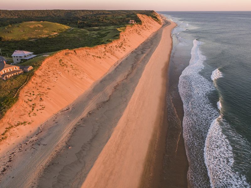

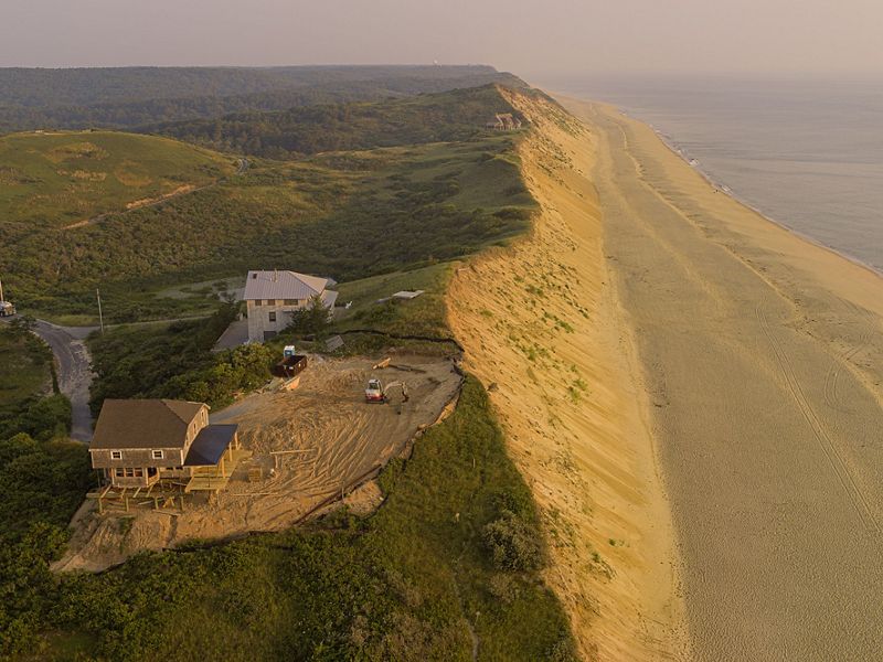
Losing Time
Cape Cod National Seashore, Massachusetts
The seaside homes and golden bluffs of Cape Cod were made famous by artist Edward Hopper’s 20th-century paintings. But those famous bluffs are losing an average of 2 to 3 feet of land per year. The owners of this house received permission to move their home back from the edge by 90 feet. The first picture was taken in 2015 and the second in 2021, after the house was moved. Many coastal residents don’t have the land or the financial resources to move (or raise) their homes, however. As a result, in some instances, less-affluent communities have been more likely to be displaced than wealthier neighborhoods. A number of environmental organizations, including TNC, are working to address this inequity while keeping communities safe.

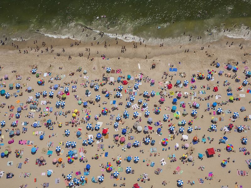

Hurricane Sandy
Avon-by-the-Sea, New Jersey, and Fire Island, New York
In 2012, Hurricane Sandy had a profound effect on the U.S. Atlantic coast, causing an estimated $70 billion in damage and killing more than 200 people. It also degraded parts of the shore itself, accelerating erosion in some areas. At Fire Island National Seashore, an uninhabited barrier beach on Long Island, the storm created an entirely new inlet. The new water flow improved the bay’s water quality. Sandy closed some existing tidal inlets and opened many more from North Carolina to New England. In the months following Sandy, some communities recovered quickly while others struggled or simply never returned. In the first image, the beach of Avon-by-the-Sea is seen eight months after the storm.

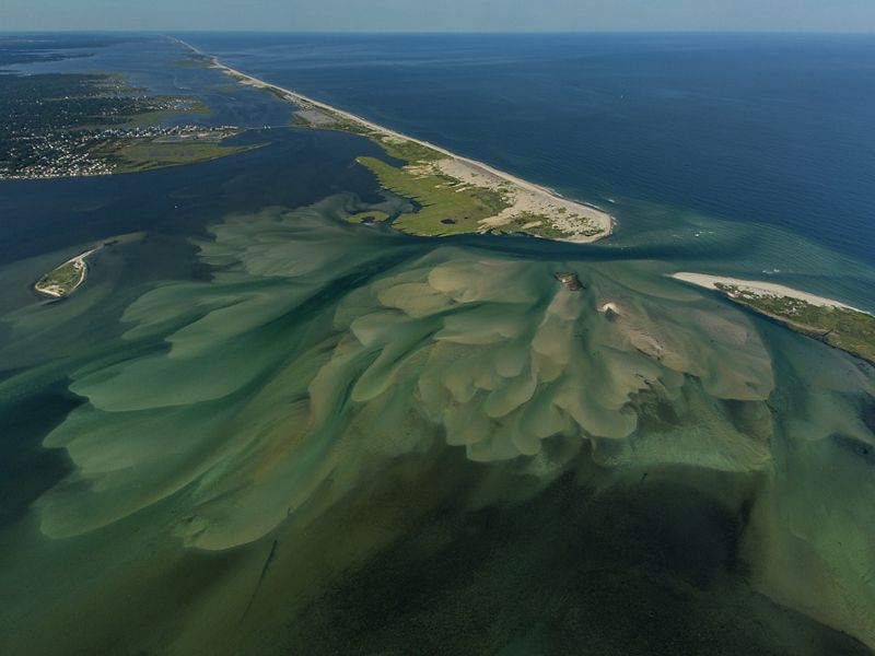
Looking Ahead
Cedar Grove Beach, Staten Island, New York
Ten years on from Hurricane Sandy, many communities have sought—and implemented—ways to adapt. On New York’s Staten Island, the U.S. Department of Agriculture’s Natural Resources Conservation Service partnered with TNC to buy 11 storm-damaged homes in New Dorp Beach and Midland Beach (seen here in the middle distance). The properties have been cleared and reseeded with native plants. Next, TNC will donate the land to New York City to help make the community safer. Elsewhere the Governor’s Office of Storm Recovery has purchased hundreds of endangered homes as a part of a buyout program that did not exist before Sandy.
The Fall 2022 Issue:

Pine Country: Bringing Back Longleaf Pine Forests
For millennia, longleaf pine forests stretched 92 million acres across the U.S. Southeast. Today, less than 5 million acres remain. But a growing effort to recover this ecosystem is taking root.

An Interview with a Seed Collector
Each year Keith Bennett, a seed harvest and restoration technician for The Nature Conservancy, scours Missouri fields for more than 200 native plant species.

The Mangrove Mothers
The women of Pate Island are fixing Kenya’s coastal forests one seedling at a time.