

Piloting Living Shorelines in New England
TNC and partners are exploring living shoreline opportunities and best practices in the Northeast
The point at which the land meets the sea is home to some of the most precious and valuable natural resources. These rich and complex coastal ecosystems provide a multitude of benefits to both people and nature. Not only do they supply habitat for marine and bird wildlife, but they also serve as barriers to storms, offer flood protection and improve water quality by filtering out impurities.
But these ecosystems are under threat. Populations are moving in greater numbers to coastal areas, bringing with them increasing development and damaging land-use practices. Climate change is causing more frequent and more intense storms, and sea levels continue to rise, increasing erosion, inundating coastal wetlands and threatening people, property and livelihoods. All of these factors have reduced the resilience of our coastal communities and made them more prone to disruptions and disasters.

In years past, the solution to these threats would have been to build elements of gray infrastructure, such as seawalls or rip-rap, as a means to prevent seawater from reaching and destroying inland areas. Such hard structures, however, damage habitat and disturb the dynamic natural continuum of these coastal areas. And if they fail, they usually fail catastrophically (think a seawall collapsing onto the beach) and are expensive to repair or replace. A better alternative is to create green infrastructure, such as living shorelines.
What Are Living Shorelines?
Living shorelines are natural approaches to protecting our coasts against erosion and flooding. These nature-based solutions can take many forms and employ primarily native or natural materials in their construction. They use vegetation or other living elements alone or in combination with hard substances like oyster reefs and rocks to create structures that enhance and protect the coastline. According to the National Oceanic and Atmospheric Administration (NOAA), “Living shorelines connect the land and water to stabilize the shoreline, reduce erosion and provide ecosystem services,” including creating habitat and improving water quality, to enhance coastal resilience.
Living Shorelines in New England Conditions
Living shorelines have been implemented and are more prevalent in other parts of the United States compared to the Northeast region. While they have been shown to help reduce impacts of flooding and storm damage, there is a lack of widespread adoption of this kind of shoreline stabilization. The region also lacks performance data to show how well living shorelines hold up to the region's brutally cold winters, icing conditions and large tidal ranges. These factors can make it difficult for vegetation to become established, for example.
Additionally, since many approaches to living shorelines require construction in nearshore environments (to prevent erosion and provide environmental benefits), they trigger rigorous permitting processes, which are geared toward preventing negative environmental impacts.

In the face of these challenges and to better understand how living shorelines perform in New England settings, The Nature Conservancy led a regional partnership with the Northeast Regional Ocean Council, state Coastal Zone Management programs and local organizations to advance the policy and practice of living shorelines such that they become more widely adopted in the places where they can be appropriately sited and designed.
The body of work is being funded by the National Oceanic and Atmospheric Administration (NOAA). To achieve this, several demonstration projects were built and several more have been monitored (using monitoring protocols developed specifically with our region in mind) to determine their effectiveness and impacts. Lessons learned from this work will be used by coastal engineers, permitting agencies and property owners as they plan future living shoreline projects—from design, permitting, and construction to monitoring and maintenance.
Case Studies
The five demonstration projects highlighted here illustrate several of the living shoreline types implemented across the New England region. Each case study explores site characteristics, the reason for considering a shoreline treatment, design and permitting, construction, maintenance and monitoring, and more.
Explore New England Living Shoreline Projects
Explore five different living shoreline demonstration projects across diverse New England settings and conditions to learn more about how we can use nature to strengthen our coastlines and protect our communities.
Maquoit Bay
Brunswick, Maine
Problem: Erosion along the marsh edge at Maquoit Bay Conservation Land threatened this coastal ecosystem.
Solution: Install an oyster shell sill comprised of biodegradable and synthetic materials in conjunction with tree runners to help decrease erosion of the marsh edge.
Wagon Hill Farm
Durham, New Hampshire
Problem: Degraded coastal salt marsh led to erosion of the shoreline.
Solution: Construct a sill—a low mound of rocks along the shoreline—to restore and protect the salt marsh behind it.
Collins Cove
Salem, Massachusetts
Problem: Substantial flooding threatened the bike paths and sidewalks along the shore, as well as the marsh and adjacent properties.
Solution: Restore the salt marsh along the shore using coir logs (a natural fiber product), sand fill and native vegetation.
Rose Larisa Park
Narragansett Bay, Rhode Island
Problem: Pounding waves eroded the shoreline and threatened the public park.
Solution: Create a living shoreline and stabilize the bank using a combination of stones, coconut fiber logs and native vegetation to reduce erosion, improve sand accretion and restore essential coastal habitat.
Stratford Point
Housatonic River, Connecticut
Problem: Decades of pollution and loss of the original salt marsh has caused significant erosion of the shoreline.
Solution: Install a living breakwater using concrete reef balls and plant marsh grass to slow waves coming ashore, increasing sediment deposition and creating habitat.


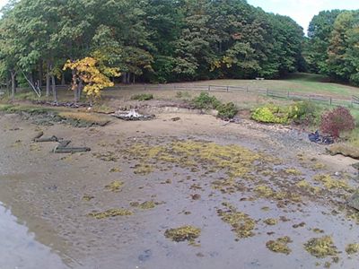
Maquoit Bay Conservation Land is a permanently protected 124-acre preserve located along Maquoit Bay. The land is owned by the Town of Brunswick and is protected by the Brunswick-Topsham Land Trust. It is a diverse ecosystem of woodland, salt marsh and clam beds. Maquoit Bay is an area of ecological significance that supports a diversity of plant and animal species such as spartina saltmarsh, migratory shorebirds and horseshoe crabs.
For many years, sections of coastal bluffs and marsh edges of the Conservation Land have been eroding. In order for marshes to expand and grow—a naturally occurring migration to higher ground to accommodate sea-level rise—they need soil or sediment, which naturally accumulates over time as it travels from higher ground to wetland levels.
To solve this erosion problem using more natural approaches (as opposed to the traditional hardened shoreline approaches like bulkheads or rip-rap), the Town of Brunswick partnered with the Maine Geological Survey, Maine Coastal Program, Casco Bay Estuary Partnership and the Brunswick-Topsham Land Trust to create a hybrid living shoreline that uses synthetic and biodegradable materials to hold oyster shell in place, along with trees, to decrease erosion of the coastal wetland edge.
For more information about living shorelines projects in Maine, visit the Maine Department of Agriculture, Conservation & Forestry.
Want to Learn More?
Dive into all the details of the design, permitting, construction, monitoring and maintenance for the Maquoit Bay living shoreline project.


Wagon Hill Farm is an iconic landmark and a public property of cultural significance in the town of Durham. The space offers recreational opportunities such as hiking, photography and dog walking.
The property includes a substantial salt marsh that has protected the property for decades; however, over time, the salt marsh has eroded and degraded. In the face of rising sea levels and in the interest of restoring ecosystem health, the Town of Durham created a multi-stakeholder collaborative task force to help design and implement a living shoreline.
The project aimed to manage shoreline erosion and restore natural habitat while ensuring that Wagon Hill Farm continues to serve as an important community asset for recreation, conservation and history. The living shoreline consists of a constructed sill using rocks and trees and their root wads as the seaward side of the project site, with fill and native plantings restoring the marsh going shoreward and higher in elevation.
To learn more about the living shoreline project at Wagon Hill Farm, check out this informative video walkthrough of the project.
Want to Learn More?
Dive into all the details of the design, permitting, construction, monitoring and maintenance for the Wagon Hill Farm living shoreline project.
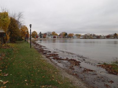


Collins Cove is a coastal bay in Salem located between Bridge Street and Salem Willows. It has heavy rock rip-rap structures on the east side of the bay, a large seawall with a baseball field and playground on the west and a bike and walking path along its southern edge.
The bike path and sidewalk regularly flood substantially, threatening the structural integrity of nearby houses. To prevent the destruction of land and property, Salem Sound Coastwatch, the City of Salem, the Massachusetts Office of Coastal Zone Management and TNC collaborated to build a living shoreline to naturally address flooding and erosion.
The team determined that the most appropriate living shoreline technique for Collins Cove would be to restore the fringing salt marsh using bioengineered materials such as coir logs, limited sand fill to provide a planting substrate and plantings of marsh grass. The existing rock sill was incorporated into the design to help buffer the marsh from waves.
Want to Learn More?
Dive into all the details of the design, permitting, construction, monitoring and maintenance for the Collins Cove living shoreline project.
Rose Larisa Memorial Park is a 10-acre public park that provides the surrounding community with a green space, including a walking trail, picnic tables and benches, and scenic views of Narragansett Bay. The property is owned by the City of East Providence and provides access to a long stretch of beach along the bay, with a tree-lined bluff rising 20 to 30 feet above the shoreline.
On windy days, waves are driven onto the narrow beach, undercutting the bluff and causing erosion. To control this erosion and stabilize the beach and slopes, a team of partners created a living shoreline using rocks, coconut fiber logs and native vegetation. This natural solution also helped restore habitat and improve the quality of this recreational area. The project received addtional grant support from 11th Hour Racing and the Rhode Island Coastal and Estuarine Habitat Restoration Trust Fund.
Want to Learn More?
Dive into all the details of the design, permitting, construction, monitoring and maintenance for the Rose Larisa Memorial Park living shoreline project.


Stratford Point is a peninsula near the Housatonic River. The former site of a gun club for 50 years, the point had been cleaned up, but loss of the area’s salt marsh caused significant erosion of the shoreline. These problems only worsened with the increasingly harsh effects of climate change, such as sea-level rise and more intense storms, as well as from shoreline development, pollution and the construction of hard structures like retaining walls.
In May 2014, a coastal restoration team from Sacred Heart University, with help from DuPont, constructed a 150-foot living shoreline pilot project in the intertidal zone adjacent to the Housatonic River Estuary shoreline of Stratford Point. The living shoreline pilot project, which employed concrete reef balls and a smooth cordgrass marsh, was constructed as a proof-of-concept project to demonstrate the potential for living shorelines to decrease erosion of intertidal sediments and restore wildlife habitat. Based on the positive results of this pilot, the living shoreline was expanded in November 2016 to protect and enhance an additional 750 linear feet of shoreline.
Want to Learn More?
Dive into all the details of the design, permitting, construction, monitoring and maintenance for the Stratford Point living shoreline project.
Key Takeaways
Evidence from other regions of the United States, including the Southeast, suggests living shorelines can reduce erosion while providing stormwater storage and habitat for wildlife, as well as aesthetic and recreational opportunities. The data from these projects will help inform how we should implement different living shoreline approaches—from coastal bluff stabilization and dune restoration, to marsh creation and living breakwaters—in the Northeast.
The collaborative effort undertaken to document the design and permitting processes and construction and maintenance needs, as well as to establish monitoring and regulatory guidance, provides information to advance the policy and practice of living shorelines in New England.
Going forward, property owners and the coastal engineering and regulatory communities now have more information to mainstream and appropriately scale up the use living shorelines—using nature to build coastal resilience and benefit nature.
New England Living Shoreline Projects


More On Living Shorelines

Harnessing Nature’s Designs Along the Shore
Nature-based solutions can help reduce coastal erosion and flooding to protect coastal infrastructure and communities.

Building a Shoreline
The Boyd Living Shoreline in South Carolina will help reduce erosion at Morgan Park while creating new habitat for crabs, oysters and shrimp.

Coastal Nature Fights Climate Change
Protecting and restoring natural habitats can help communities adapt to rising sea levels and more frequent and intense storms.