Using Satellite Images & Machine Learning to Map Surface Water
Protecting nature starts with science.

Voices From the Field
"Nothing is more critical to Arizona right now than understanding and tracking our water systems. Technology offers us the chance to generate surface water maps in unprecedented detail." -Jessie Pearl, TNC Arizona's Freshwater Scientist
Project Objective
In Arizona, water can be fickle. Major rivers may be vibrant, aquatic systems may be resilient for miles, then run completely dry for a stretch, and then return to a full flow further downstream. Understanding where and when water is flowing is crucial to helping us assess a river system’s health and informing our water management decisions. The challenge is how to collect the most accurate and useful information about surface water flows.
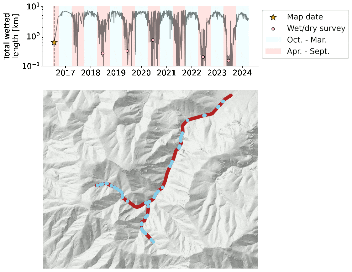
Since 1999, The Nature Conservancy (TNC) has worked with volunteers and partners to ‘wet/dry’ map the San Pedro River, one of the last major undammed rivers in the southwestern United States. The goal of the mapping is to assess aquatic connectivity and to evaluate the effectiveness of conservation actions on surface water presence. Volunteers conduct the survey every June, the hottest and driest time of year, to capture an assessment of baseflow.
While this 25+ year data set is rich, it has limits. Each year, the length and location of the survey changes, making consistent analysis challenging, and the collection of one data point per year may not capture other seasons or phenomena of interest (for example, a large monsoon season that occurs after the survey).

TNC Arizona freshwater scientist Dr. Jessie Pearl is now working with Dr. Dana Lipides from the USDA Agricultural Research Service (ARS) and Dr. Shang Gao from the University of Arizona to determine if they can use remotely sensed imagery and machine learning to more accurately map surface water presence in the San Pedro River basin across the year.

Progress & Opportunity
Today, commercial satellites are revolutionizing the data available to scientists, and they can offer unprecedented access to information about the presence of water in a stream channel. The challenge is processing the sheer quantity of remotely sensed imagery data for analysis. That’s where Dr. Pearl, Dr. Lipides and Dr. Gao hope a machine learning model can help. What is machine learning? It’s a specific type of artificial intelligence (AI). Machine learning can identify patterns and extract valuable insights efficiently from the thousands of images taken by satellites. In this case, the science team is building a machine learning model to detect water presence in the San Pedro almost daily with high-resolution satellite images. This new approach wouldn’t be possible, though, without the valuable data collected through the annual volunteer wet/dry mapping. That’s because scientists are using the ground-based observation data to train their machine learning model. By harnessing the latest technology, the scientists are greatly increasing the usability of the field-collected wet/dry data.
The team already had initial success piloting this model in the regions of Cienega Creek Basin and Ramsey Canyon, and they’re hoping to expand its use this year—providing nearly real-time data to inform the way we protect and sustain these dynamic and vulnerable water resources.

More Stories from Arizona

Arizona Science Homepage
Learn how our team brings together leading experts to collect evidence and develop novel solutions for conservation.

Safeguarding Freshwater Ecosystems Across Arizona
Freshwater resources in Arizona serve as a critical water supply for the people of Arizona and surrounding areas. Discover how we are addressing water security for people from all communities.

Patagonia-Sonoita Creek Preserve
Located in a lush floodplain between the Patagonia and Santa Rita Mountains, this preserve has some of the region’s richest streamside habitat. It is home to a great diversity of birds and wildlife.