New Urban Heat Map Underscores Need for Trees in Philadelphia Neighborhoods
City’s Highest-Resolution Heat Map Shows Investments in Philadelphia’s Urban Forest & the Philly Tree Plan Would Equitably Address Extreme Heat
Media Contacts
-
Kathleen McFadden
Media Relations Manager
The Nature Conservancy
Phone: 610-368-7108
Email: k.mcfadden@tnc.org
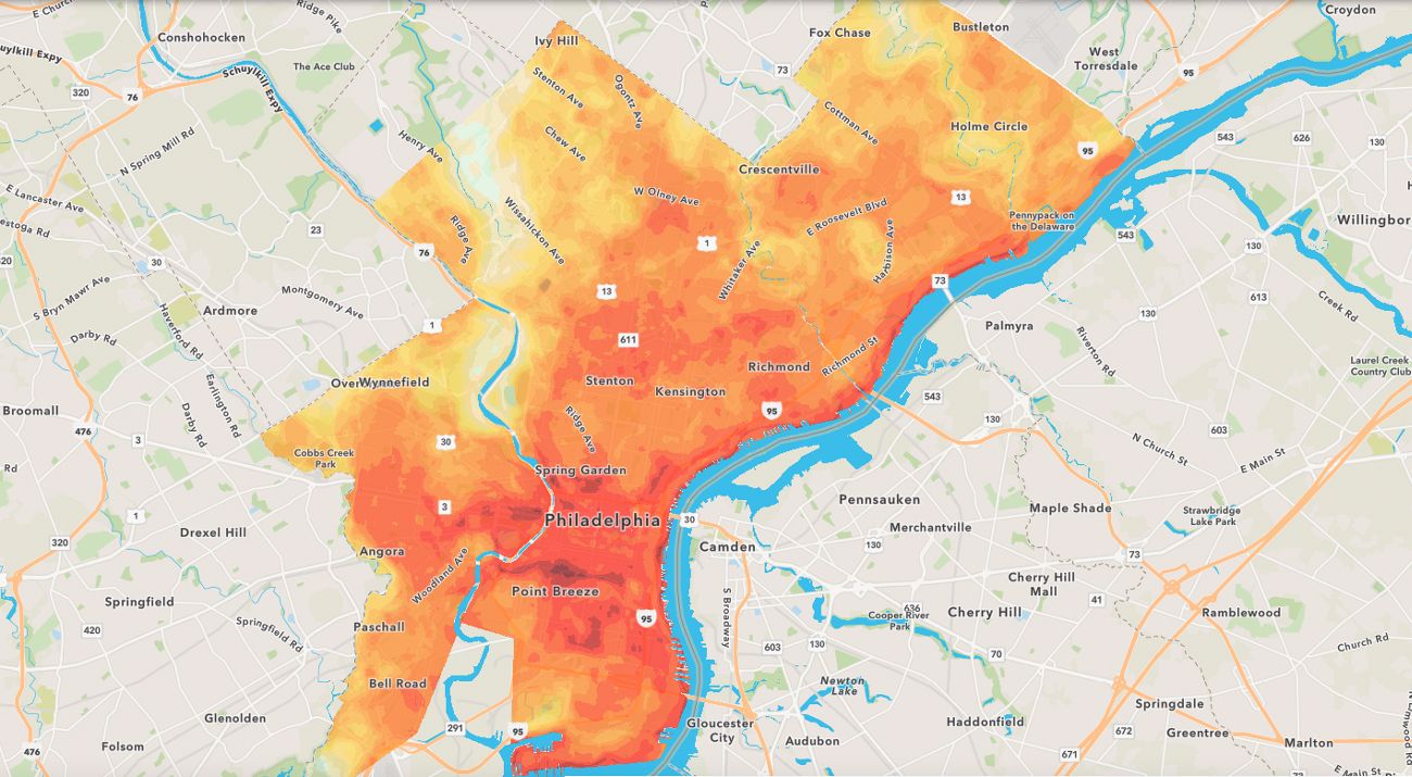
The Nature Conservancy (TNC) in Pennsylvania today released new results and analysis of a federally-funded community science study that produced Philadelphia’s highest-resolution heat map to date. The analysis—detailed in an interactive ArcGIS StoryMap titled Citywide Heat Ride—may inform future urban forestry and equitable conservation projects, including the Philly Tree Plan, to better protect Philadelphians from dangerous heat waves and extreme weather events made worse by climate change.
TNC’s analysis visualizes high-resolution heat data to show the hottest, most heat-vulnerable areas of the city with the least amount of tree canopy, or “Areas of Need for Trees.” The high-resolution data used in TNC’s analysis and new interactive web map was collected during the Philadelphia Urban Heat Mapping Campaign, a community science study mapping the city’s “urban heat islands.”
According to TNC’s analysis, some of the areas of highest need for trees include Kingsessing, Grays Ferry and Hunting Park. The Kingsessing neighborhood, for example, is an area of critical need for trees based not only on heat, but on other factors like income, health, and the neighborhood’s minimal 14% tree canopy—the layer of leaves and branches that cover the ground from a bird’s-eye view. Grays Ferry has just 6% tree canopy.
TNC also compared the new high-resolution heat map with priority areas from the Philly Tree Plan, the city’s strategic plan to grow, protect and care for Philadelphia's tree canopy. The comparison allows communities and city officials to make more informed decisions about where to plant and care for trees, as well as advocate for trees where they are needed most. The analysis shows how the Philly Tree Plan would be transformational in equitably addressing extreme heat, public health, and quality of life for Philadelphia neighborhoods. TNC served on the Philly Tree Plan Steering Committee and is one of the partners assisting with the joint implementation of the plan.
“As average temperatures continue to rise due to a changing climate, it’s more critical than ever to employ nature-based solutions in our communities,” said Lori Brennan, Executive Director of TNC in Pennsylvania and Delaware. “TNC applauds the City of Philadelphia for its urban forestry leadership and we look forward to continuing to work with residents and our partners across the region to advance equitable solutions that protect both people and nature.”
Previous research shows urban trees have significant positive benefits for both cities and their residents including slowing stormwater runoff, reducing energy use, reducing carbon emissions, boosting student achievement, and reducing crime. In Philadelphia, urban trees address a wide variety of goals for multiple city agencies.
In the summer of 2022, Philadelphia was one of just 16 cities worldwide selected by the National Oceanic and Atmospheric Administration (NOAA) to collect heat data used to map the city’s heat islands. The collaborative effort involved multiple community groups and 50 individuals from across Philadelphia who formed teams to raise awareness of their community’s experience with heat. With sensors attached to their vehicles, participants gathered more than 38,000 data points of temperature, humidity and GIS location, covering 105 square miles of the metro area in a single day. The resulting maps display how heat varies across neighborhoods in Philadelphia on a hot summer day and how local landscape features affect temperature and humidity.
Temperatures soared as much as 10.5 degrees higher in some areas than others at the same time of day in July; the max temperature recorded was 95 degrees. Initial findings revealed that areas with more concrete, roads, parking lots, and fewer trees trap heat, making them hotter on average. Tree-dense areas, on the other hand, stayed cooler throughout the day.
Quote: Richard Johnson
It was amazing to see these community scientists go out to record so many measurements. There is just no other way to get this information, and it will be incredibly valuable for years to come.
“It was amazing to see these community scientists go out to record so many measurements. There is just no other way to get this information, and it will be incredibly valuable for years to come,” said Richard Johnson, Urban Climate Resilience Manager at TNC who led this results analysis and organized the heat-mapping study last summer while at the Academy of Natural Sciences, a partner on this project.
Johnson continued: “Releasing this StoryMap is a way to honor the participants and show that their efforts are leading to change. The heat maps and analysis allow communities to easily access and explore solutions to extreme heat and advocate for trees where they are needed most.”
The measurements taken during the heat mapping campaign differ from those used in previous heat maps. Temperatures used in existing heat maps were taken by satellites that record surface temperatures, like the tops of buildings. The heat mapping campaign, however, measured air temperature and humidity close to the ground, which more closely represents the heat people feel.
Surface temperatures can be very valuable, but people don’t live on top of buildings,” added Johnson. Since measurements were collected at multiple times of day (morning, afternoon, and evening), the maps also capture how different areas heat up and cool down – a feature not available in other heat maps, and one that allows for more informed decisions to address extreme heat depending on the time of day.
Philadelphia Parks & Recreation and the Pennsylvania Horticultural Society (PHS) were key partners in the original heat mapping campaign and the analysis of the results.
“PHS continues to make strides in raising money for Philadelphia’s urban forest and working with residents to target investment in the lowest canopy neighborhoods where trees can deliver the greatest impact. The results of TNC’s Citywide Heat Ride report provide further evidence of the important role trees play in improving health and well-being for all. At PHS, the results of this study will help us to continue advocating for sustained investment in tree planting and stewardship, and to drive awareness and support for our work planting thousands of trees each year in the Philadelphia region,” said Matt Rader, President of the Pennsylvania Horticultural Society.
Residents interested in getting involved have several options for tree planting and care activities:
- Sign up for a free yard tree through TreePhilly, and learn how to host a TreePhilly giveaway.
- Apply for a free street tree from PHS or join the PHS Tree Tenders Program. PHS works with residents to handle tree permits, cut sidewalk pits, and get more trees in their neighborhoods. Additionally, the organization trains hundreds of Philadelphia residents every year on how to plant and care for trees and how to start a Tree Tenders group in their community.
- Become a Philly Forest Steward. Volunteer year-round to help preserve Philadelphia’s much-needed natural lands by controlling invasive plants, caring for young trees, monitoring restoration sites and removing litter.
The Philadelphia heat mapping study and TNC’s StoryMap analysis were supported by The Nature Conservancy in Pennsylvania, The Academy of Natural Sciences of Drexel University, CAPA Strategies, Philadelphia Parks & Recreation, the Pennsylvania Horticultural Society, and the William Penn Foundation. Community partners include Drexel EcoReps, Nueva Esperanza Inc., Historic Fair Hill, Northeast Tree Tenders, Philly Thrive, Residents Organized for Advocacy and Direction, Southwest Community Development Corporation, Tacony-Frankford Watershed Partnership, and United Neighbors of West Oak Lane.
For more information, visit nature.org/PAUrban.
Stay in Touch
Sign up to receive monthly email conservation news & updates from Pennsylvania.

The Nature Conservancy is a global conservation organization dedicated to conserving the lands and waters on which all life depends. Guided by science, we create innovative, on-the-ground solutions to our world’s toughest challenges so that nature and people can thrive together. We are tackling climate change, conserving lands, waters and oceans at an unprecedented scale, providing food and water sustainably and helping make cities more resilient. The Nature Conservancy is working to make a lasting difference around the world in 81 countries and territories (40 by direct conservation impact and 41 through partners) through a collaborative approach that engages local communities, governments, the private sector, and other partners. To learn more, visit nature.org or follow @nature_press on X.


