

Case Studies: Living Shorelines in New England
An in-depth look at five living shoreline demonstration projects TNC and partners piloted throughout the Northeast
Living shorelines are a critical part of the toolkit for communities along the coast facing erosion, flooding and the pile-on effects of climate change. These natural approaches to protecting our coasts have been shown to help reduce impacts of flooding and storm damage in other parts of the United States, but there is a lack of widespread adoption of this kind of shoreline stabilization.
In the Northeast, The Nature Conservancy is leading a regional partnership with the Northeast Regional Ocean Council, state Coastal Zone Management programs and local organizations to advance the practice and policy of living shorelines through pilot projects and monitoring existing sites.
From this body of demonstration projects, five different living shoreline types—one in each coastal New England State—were selected to illustrate key components of implementation. From identification of the issues at a coastal property; through design and permitting; construction; and monitoring and maintenance, the case studies show examples of how living shorelines have moved from concept to reality.
Each example highlighted here details the engineering plans, monitoring metrics, timelines, photos and more. These nature-based solutions have the potential to address coastal erosion while providing wildlife habitat and other benefits, and the case studies below are examples that can be modeled and learned from.
Looking for an overview of these projects?
To learn more about what makes a living shoreline and for an introduction to these five projects, check out our story on New England Living Shorelines.

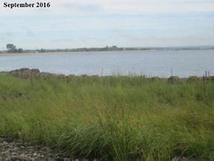
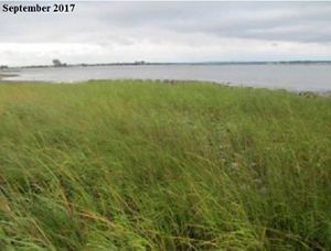
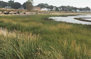
Maquoit Bay
Brunswick, Maine
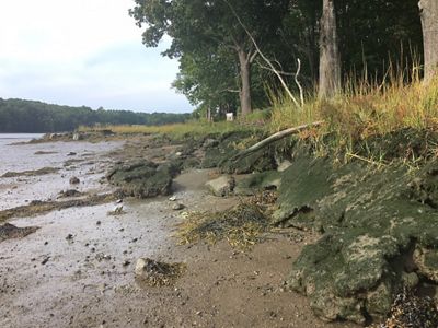
Problem: Erosion along the marsh edge at Maquoit Bay Conservation Land threatened this coastal ecosystem.
Solution: Install an oyster shell sill comprised of biodegradable and synthetic materials in conjunction with tree runners to help decrease erosion of the marsh edge.
Design, Planning and Permitting

Project Partners
- Northeast Regional Ocean Council
- National Oceanic and Atmospheric Administration
- Brunswick-Topsham Land Trust
- Maine Geological Survey
- Maine Coastal Program
- Casco Bay Estuary Partnership
- Town of Brunswick
Costs
$25,000
For this site, the project team developed a demonstration treatment that tested both biodegradable (coir bags filled with oyster shell) and synthetic (GeoReef) gabions filled with oyster shell. It also included the placement of 11 shore-perpendicular logs (10 to 12 inches in diameter, 10 to 12 feet in length) as “tree runners” in order to help break up currents and ice during the winter months—this technique is commonly incorporated in living shorelines along the Great Lakes. The project team worked with commercial suppliers Tensar and BMT Fibers to develop and customize the synthetic and biodegradable materials. In addition, appropriately aged oyster shell was acquired from the University of New Hampshire and aged an additional year in Brunswick, Maine.
State and federal permits were required from a number of sources, including the Maine Department of Environmental Protection and the U.S. Army Corps of Engineers; since the town of Brunswick is the owner of the site, no local permits were required.
Construction
The demonstration design at this site called for a 50-foot treatment with natural controls on either side. Construction began in August 2019 and was completed in August 2020.


Monitoring

Specifically for the Maquoit Bay project, the monitoring plan developed by the Casco Bay Estuary Partnership (CBEP) is derived from the EPA-approved Quality Assurance Project Plan (QAPP) for Monitoring Demonstration Living Shorelines Projects in Maine. Monitoring highlights include monitoring for
- Context
- Geophysical environment
- Erosive forces
- Biota and habitat
- Structural integrity
Detailed monitoring was scheduled for pre-construction, as-built (post-construction), spring/early summer (April–June), fall/late summer (August–October) and winter (as possible). Four transect lines were established at the project site, with plots for vegetative and biologic assessment along each line.
Surveys
Several surveys were completed throughout the project.
- A pre-construction survey (including establishment of survey benchmarks using static RTK GPS occupations) was recorded by the Maine Geological Survey (MGS) and CBEP.
- An as-built topographic survey was completed by MGS and CBEP.
- Detailed topographic, biologic and vegetative surveys were completed by CBEP pre-construction, post-construction and at three additional times through February 1, 2021.
Photography
- MGS documented the site using photography on eight separate dates post-construction, through the end of January 2021.
- CBEP installed a game camera on the site, which records photographs every half hour.
The team concluded that careful and complete, even excessive, photo documentation is essential for recording changes not anticipated or not well captured by other formal monitoring and data collection.
Additional Considerations
Pre-project monitoring needed to be able to minimize the impact of an evolving design and the potential impact of construction activities, as well as be flexible to accommodate changes in as-built condition. Moreover, in-situ markers (such as stakes, benchmarks, etc.) that had been established to support long-term monitoring were vulnerable to construction activities. Coordination among monitoring, design and construction personnel minimized these concerns.
At the request of the National Oceanic Atmospheric Administration (NOAA) National Marine Fisheries Service (NMFS), additional monitoring techniques for keeping track of plastic degradation were added to the monitoring protocols.
Several methods were tested for determining the position of shorelines and structures in three dimensions. The most flexible approach involved using Real Time Kinematic (RTK) GPS for initial surveys and to establish working benchmarks while relying on a total station for data collection. This workflow has proven especially important when working under tree canopies.
Lessons Learned
- Use a heavier weight biodegradable rope instead of twine for tying down installations.
- Anchor logs differently, lashing them with anchors from either side and lag screwing both anchors at one spot instead of attaching anchors to the logs using one duckbill and lag screw. This would double the number of duckbills needed but would likely result in a more resilient lashing and less log rotation.
Maintenance
Maintenance at the Maquoit Bay site has not been significant and has included the following:
- Besides some slight settling, the GeoReef appears to be holding up quite well and has not required any maintenance.
- Several logs have rotated slightly but have not required re-anchoring.
- Several biodegradable bags have had to be replaced.
- Portions of the bag installation have needed to be re-staked and re-twined using a larger diameter biodegradable twine material.
Note: Maintenance during winter months is challenging. Normally accessible by boat during non-winter months, the site can only be reached in the winter by hiking in with supplies, so workers have found that using wheelbarrows to carry the supplies is useful.
Conclusion

The Maquoit Bay living shoreline demonstration project has thus far been deemed a success. Based on evidence gathered to date, the project has achieved its goals and has remained resilient under changing conditions. Monitoring will continue for a total of five years.
Additional Resources
Maquoit Bay: Brunswick-Topsham Land Trust
Maine Geological Survey: Living Shorelines
Before-and-After: Photo Slider by the Greater Portland Council of Governments (GPCOG)

Design, Planning and Permitting


Project Partners
- Town of Durham
- New Hampshire Department of Environmental Services Coastal Program
- New Hampshire Department of Environmental Services Wetlands Bureau
- University of New Hampshire
- The Strafford Regional Planning Commission
Costs
$290,000
The Wagon Hill Farm site was an eroding shoreline with steep scarps at low marsh and large shade trees bordering the high marsh. Some of the shoreline had no remaining salt marsh, and a nearby path encouraged people and dogs to walk on the fragile marsh.
The goals of the living shoreline project were to
- Manage erosion
- Stabilize the shoreline
- Restore habitat
- Enable salt marsh migration
- Improve site aesthetics
- Increase public awareness
Planning and design for the project began in 2017–2018. The expected timeline for the project as a whole, including a five-year monitoring plan, was January 2019–December 2023.
In addition to town approvals, the project required a State Wetlands permit and a U.S. Army Corps of Engineers permit.

Construction
Construction began in April 2017 when a temporary access road for heavy equipment vehicles was built. A portion of rock sill made of reused stone and root wads was built, and marsh was planted behind it for sediment and erosion control. This sequence was repeated until the earthwork and sill were complete. Some of the sediments were imported, while some were acquired from the town.
To create a tidal buffer, planting was done from low to high marsh. Spartina alterniflora was planted in the low marsh areas; Spartina patens was planted in the high marsh areas. A protective fence and viewing deck were also constructed; educational signage was installed to inform the public about the restoration.
A continuous coir log was installed at the high marsh–low marsh elevation. Plants that had been grown the previous year were installed as turfs. Fifteen hundred of these plants were purchased, and 10,000 of them were supplied by the turf grower.
Living Shoreline Construction


Several challenges arose during construction. The team realized that to prevent slope failure with liquefied fill sediments, more stone needed to be added to hold the sediment together. In addition, the low marsh turf that was installed had been grown in a freshwater flooded area during the spring; once installed at the site, many plants could not survive the normal cycle of saltwater flooding. The flooding also weighed down the turfs and made installation difficult. As a result of these turf issues, there were not enough turfs to cover the planned area, and the distance between each turf needed to be reduced.
Monitoring
The project will be monitored for five years. A pre-construction survey was conducted to document baseline conditions, and an as-built survey was undertaken after construction to compare conditions to the baseline. The first year of monitoring was scheduled to start in September 2020, after the site had established one full growing season post- construction.

The table above outlines the parameters used for monitoring the site. The site survey and erosion pins will determine whether erosion has been reduced and will also show the areas of habitat restored. The presence and health of vegetation, invertebrates and fish will show the habitat value of intertidal marsh. The accretion rate will show how the marsh is interacting with physical processes to build in elevation. The plants in the tidal buffer zone will show the value of habitat at the upland edge. And community engagement will be gauged by the level of web usage and interaction with signage on site.

Maintenance
Conclusion


Design, Planning and Permitting

Project Partners
- Salem Sound Coastwatch
- Massachusetts Office of Coastal Zone Management (CZM)
- Hatch Chester Engineers
- City of Salem
The goal of this living shoreline project was to make this popular recreational area more resilient to flooding and storm surge. During the planning and design phase, the project team examined and considered a number of factors:
- Wetland delineation
- Erosion rates and trends
- Aerial photography
- Topographic information
- Physical survey
- Sea level rise projections
- FEMA flood mapping
- Nearshore geology and seafloor mapping
- Sediment and sediment transport
- Marine resources
- Tidal datums
- Current usage by the public
The team determined the most appropriate living shoreline technique for Collins Cove would be a fringing salt marsh creation/restoration using bioengineered techniques with coir logs, limited sand fill to provide a planting substrate and plantings of Spartina patens and Spartina alterniflora. Existing site features such as the rock sill would be incorporated into the design. The proposed design would be implemented landward of the sill to take advantage of the wave buffering by the rocks.
The following permits and regulatory considerations are applicable to this project.
- Wetland Protection Act—Notice of Intent as an Ecological Restoration Project (City of Salem Conservation Commission)
- Chapter 91 Public Waterfront Act MA Environmental Policy Act Filing
- USACE (US Army Corps of Engineers—Category 2, GP22 beneficial project and pre-construction PCN greater than 100 square feet of plantings
Restoration Design Drawings


Construction
Multiple arcuate dual coir log segments were laid out along the upper intertidal area in the marsh establishment area. The plan was for 10 segments along the 800-foot project area. A small gap was left between segments to allow draining. Each section was approximately 75 feet in length. High-density, premium-quality, 12-inch diameter coir logs of 12 foot length were recommended.
Due to the rocky-gravel nature of intertidal zone shoreward of the existing rock sill, it was necessary to add sand to provide adequate growing substrate for the plants. Vegetation was planted at appropriate tidal elevation ranges for optimal growth:
- Spartina alterniflora—mean sea level (MSL) to mean high water (MHW).
- Spartina patens—MSL to mean higher high water (MHHW).
- A mix of Spartina alterniflora and Spartina patens was planted in a zone near the MHW mark.
- Other high-marsh plants: Distichlis spicata (spike grass), Juncus gerardii (black grass) and Solidago sempirvirens (seaside goldenrod).
Building a Living Shoreline


Maintenance
Maintenance will be conducted by Salem Sound Coastwatch. Maintenance will examine plant species, substrate settling, coir log placement/condition, erosion/deposition and impact of wave exposure.
Invasive plants, i.e., Phragmites australis and Lepidium latifolium (pepperweed), will be controlled by pulling and proper disposal of any intrusions as soon as noticed to avoid any long-term degradation of the salt marsh. Any loose netting material, anchors, stakes or other material installed to support the restoration will be examined and fixed. Large debris and trash will be removed from the marsh surface.
Conclusions
There were many lessons learned during this project that may be useful for others planning to implement a living shoreline project.
- It was beneficial to have had a multidisciplinary project team with different backgrounds. The more heads, the better!
- For site selection, take the time to discuss and document project objectives at the beginning of the process and understand the relative importance of different types of priority-setting criteria that might be used including:
– Physical
– Biological
– Social and community
– Economic
- Understand living shoreline concepts and broadly apply them in the project process to efficiently work toward project objectives (e.g., energy of environment).
- Research similar projects to take advantage of lessons learned from others.
- Get the public and other interested stakeholders involved early to present project plans and listen to any feedback that might be received.
- Complete a wetland delineation near the beginning of the project during the optimum time of year (June to September).
- Talk to state and federal regulators at an early stage in the project, as soon as conceptual plans start to take shape, and understand the critical paths for permitting.
- Get Coastal Zone Management (CZM) staff involved early in the project. They have valuable technical, programmatic and permitting experience that they are willing to share.

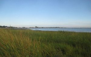
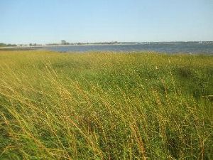
Rose Larisa Memorial Park
Problem: Pounding waves eroded the shoreline and threatened the public park.
Solution: Create a living shoreline and stabilize the bank using a combination of stones, coconut fiber logs and native vegetation to reduce erosion, improve sand accretion and restore essential coastal habitat.
Design, Planning and Permitting
Project Partners
- Rhode Island Coastal Resources Management Council (CRMC)
- City of East Providence
Costs
$232,000
Most of the Narragansett Bay shoreline adjacent to the Rosa Larisa Park in East Providence is a sandy coastal bluff vegetated with trees. The bluff runs north-south for approximately 850’. The wave and wake energy generated from the waters of Narragansett Bay were undercutting the bluff and this was further exacerbated by overtopping trees. This shoreline erosion was encroaching on the City’s parkland. The project partners looked at the potential of using limited funding to test several living shoreline bluff restoration practices at this site—practices that could be used to eventually complete erosion control on the entire site as well as be transferable to other locations requiring coastal bluff erosion control.
The project team determined the most appropriate living shoreline technique for Rose Larisa Park would be a “non-structural hybrid” erosion control treatment and an intertidal sill and marsh treatments on separate sections of the bluff. The non-structural hybrid design would be applied to 100’ of shoreline, and the intertidal sill design would be applied to 130’ of shoreline. The design would incorporate bioengineered techniques with coir logs, limited sand fill to provide a planting substrate and plantings of Spartina patens and Spartina alterniflora. Existing site features such as the rock sill would be incorporated into the design. The proposed design would be implemented landward of the sill to take advantage of the wave buffering by the rocks.
The permitting process extended from October 2017 to January 2018.
Rose Larisa Living Shoreline Plans


Construction
Construction of a hybrid bluff structure started in late April 2020 and was completed in mid-May of that year; marsh was planted in mid-May. Bluff construction included preparing the bank (removing trees and regrading) and installing a stone toe, above which 13 rows of coir logs were positioned and anchored in place. A sand cover and coir blanket were installed on top of the coir logs to shield them from UV light. The coir structure was planted with American beach grass (Ammophila breviligulata).
Living Shoreline Construction


The sill and marsh were constructed concurrently, with construction of the sill taking place during the lower tide, dry phase of the tidal cycle. The saltmarsh area was prepared using a limited sand cover. Half of the marsh area was covered with a coir blanket, and the other half was left as bare sand. This was done to assess whether there would be benefits to adding the coir blanket. Some speculate that a coir blanket may reduce goose predation of plants as well as sediment migration as the marsh establishes. Sandbags were installed in the gaps between the sills and along the north and south marsh borders. Trees were cut on the bluff to eliminate shading in the marsh area. The lower marsh area was planted with Spartina alterniflora, and the upper marsh area was planted with Distichlis spicata. Of the 1,000 plants that were used, two-thirds were S. alterniflora and one-third was D. spicata.
Posts and netting were installed around the marsh areas to discourage predation by geese. These barriers also served to define the area so that people walking along the beach would not walk through the newly planted marsh. In addition, a collapsed concrete seawall was removed and photo posts for fixed photography were installed.
Building the lower salt marsh


Monitoring
Monitoring and adaptive management since construction have included fixed and opportunistic photography three times per month during the growing season; replanting of dislodged salt marsh plugs; removal of macroalgae and debris from the marsh area; repair and replacement of goose fence netting; visual inspection for scour, accretion/erosion of sediment, flood and ebb tide flow through sills, and the presence/absence of fauna in the marsh area and on the sills.
Vegetation monitoring included a vegetation survey completed on August 28, 2020. Vegetation monitoring was conducted using a modified version of SOP 2 in James-Pirri and Roman modified by Neckles et al., 2009. Two one-meter quadrats were located along each of four transects in the marsh area, totaling four quadrats in the marsh area with the coir blanket and four in the bare sand area. The percentages of macroalgae, bare ground, rock, shell, Distichlis spicata and Spartina alterniflora were recorded within each quadrat. In addition, stem number and height of salt marsh plants were recorded in the northeast corner (quarter) of the quadrat. Quadrats were geolocated using RTK GPS. Fixed photographs were taken at the bluff treatment area, but vegetation obscured the view and the photo post will need to be relocated farther seaward. Opportunistic photos were taken at the treated and untreated bluff. Structure from motion (SfM) surveys were performed prior to construction and post-construction and are on file at the University of Rhode Island. Digital elevation models (DEMs) and 3D models have been completed for the treatment areas; baseline data are available for the entire beach and bluff.
Maintenance
Monitoring and maintenance have been carried out as needed and include completing and distributing the monitoring report, adding additional goose deterrent and moving photo posts by the bluff treatment and control bluff area. An SfM survey will be completed if the area is impacted by a significant storm.
Lots of debris and macroalgae accumulate on the salt marsh. Macroalgae are particularly prevalent during early summer, accumulating in the high marsh area. The beach is very dynamic, with sediment shifting on the bare ground in the salt marsh area. Monitoring has revealed some accretion in the area landward of sill gaps, erosion in the central marsh area and accretion in the high marsh area. Distichlis spicata plugs are growing better in the blanketed area than in the bare marsh, but it does not share the robust growth seen with Spartina alterniflora.
Conclusion
Both of the treatments have experienced two growing seasons and have performed favorably. Based on the results from testing these two different treatments, it was recommended that they should be considered as viable living shoreline alternatives to using structural material such as rip-rap and concrete walls for other shoreline erosion projects. These two applications or practices can be transferable to other coastal shoreline locations requiring similar erosion control work.
Some of the things that we have learned:
Non-structural hybrid erosion control
- The hybrid rock/vegetated coir base remains as it was constructed. But it will require small follow-up adjustments to address the small amount of slumping above the rock toe.
- Survival of the beach grass was high but took longer to root than expected. A follow-up program is needed to fill in some of the bare spots as well as to address the small amount of invasive vegetation that occurred.
- Fencing was needed to keep pedestrians from walking from the top of the bluff and down through the treatment area.
- Post construction was needed to divert stormwater runoff that flowed off the top of the bluff and into the treatment area.
Intertidal sill and marsh
- Spartina plants had a high rate of survival and have spread during the second year of growth; however, none of the Distichlis spicata which was planted behind the Spartina has survived. This is not a low marsh plant, and the elevation behind the rock weirs is too low (intertidal). The plants were submerged too long during the flood tide.
- Fencing was erected to reduce grazing by geese (which never appeared on site), but also helped keep the pedestrian traffic on this popular beach out of the planted area.
- There was no significant difference between the matted and unmatted sections. Both sections are accreting sand and sediment.
- There has been no change or movement in the shape of the five rock sills. They have withstood storms as well as regular tidal and wake energy over the last two years. At flood tide both fish and invertebrates can be observed behind the sills in the marsh.

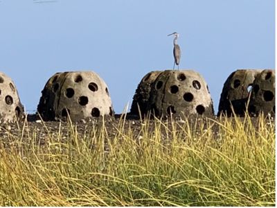
Stratford Point
Problem: Decades of pollution and loss of the original salt marsh has caused significant erosion of the shoreline.
Solution: Install a living breakwater using concrete reef balls and plant marsh grass to slow waves coming ashore, increasing sediment deposition and creating habitat.
Design, Planning and Permitting


Project Partners
- Sacred Heart University
- Corteva Agriscience
- University of Delaware
- AECOM
- CHMM
- Audubon Connecticut
Costs
$734,130
The primary purpose for installing the Stratford Point living shoreline was to:
- Stop shoreline erosion that was exposing lead shot and toxins to wildlife (the project area was the former site of a gun club for decades)
- Allow for sediment deposition to bury and effectively remove lead shot from the estuarine food web
- Allow the salt marsh to become re-established and restore ecosystem services including fish nursery, feeding stopover area for migratory shorebirds and shellfish colonization to help clean and filter the water
The timeline for the project is from April 2014 to January 2023.
The project team planned to restore the marsh, including planting thousands of plugs of Spartina, and to install a reef that would include installing multiple pallet balls. The reef would be constructed on the outer edges of the marsh that had been present in the 1980s. Each reef ball was approximately 48” in diameter. Reef balls were placed with 34cm of open space between them at the base in order to permit spawning horseshoe crabs and other fish and wildlife to pass easily through all sections of the reef. This design also permits free flowing tidal exchange and prevents storm water from being held up against the shore behind the reef.
The total living shoreline project would run approximately 900 feet, including 150 feet of intertidal zone constructed in 2014 and 750 feet of shoreline installed in fall 2016 and spring 2017. Costs were kept low by using volunteers, students and citizen scientists to help with planting and monitoring, as well as by the team learning the best and fastest installation techniques for this particular site.
Permits were acquired from the U.S. Army Corps of Engineers (USACE), and a Certificate of Permission was acquired from the Connecticut Department of Energy and Environmental Protection (CT DEEP)


Construction
In 2014, a 150-foot living shoreline pilot project was constructed in the intertidal zone of the Housatonic River Estuary shoreline. The living shoreline consists of an artificial oyster reef, constructed using 64 concrete reef balls and a smooth cordgrass (Spartina alterniflora) marsh. The project served as a proof-of-concept to demonstrate the potential for living shorelines to reduce erosion of intertidal sediments and restore wildlife habitat within the adjacent estuary. It was designed to dissipate wave energy and associated scour, and to disrupt long-shore sediment transport. Alteration of these processes was intended to result in a quiescent environment, which would allow for sediment accretion and re-establishment of the intertidal marsh that was historically present at the site.
The first reef is generally oriented parallel to the existing shoreline and consists of two staggered rows of reef balls, with 32 reef balls in each row, and is approximately 150 feet in length and eight feet in width. Three linear feet of scour protection, consisting of two- to three-inch-median-diameter stone, four to six inches deep, was placed adjacent to and seaward of the artificial reef.
In June 2014, smooth cordgrass, salvaged from the town of Fairfield, Connecticut, was planted in the intertidal zone landward of the pilot to supplement the existing sparse vegetation and reestablish the marsh that was present at the site prior to remediation. In addition, more than 2,500 smooth cordgrass plugs from a local nursery were planted in June 2015 both behind the reef and in the adjacent, unprotected intertidal area.

In November 2016, the project was expanded to stabilize and enhance an additional 750 linear feet of shoreline. The expanded living shoreline consists of four additional segments of reef balls oriented parallel to the existing shoreline. Segments range in length from approximately 150 to 250 feet, with overlapping ends to reduce edge effects and associated scour, a concern that emerged after observing localized erosion on the periphery of the original pilot reef ball arrays. Overlap was achieved by having two segments located closer to shore and two segments located farther from shore. Distance from shore was selected to correspond to the seaward extent of the historical marsh at the site. The segmented placement of reef ball arrays, rather than in a continuous line, facilitated tidal exchange and allows for the passage of marine fish and invertebrates like the horseshoe crab (Limulus polyphemus).
The team implemented an observation period of approximately five months to allow sediment transport dynamics to stabilize before commencing with marsh restoration. Substantial soil deposition took place during this period, and in April 2017, approximately 15,000 smooth cordgrass (Spartina alterniflora) plugs were planted in the area landward of the newly placed reef balls.
Reef Marsh Installation


Monitoring
Consistent with A Framework for Standardized Monitoring of Living Shorelines in the Delaware Estuary and Beyond, a modified Before-After-Control-Impact (BACI) approach was used to evaluate success of the project. Monitoring occurred annually from 2013, approximately six months prior to construction, through 2021. Comparison of bathymetric survey data collected over this period show a preliminary period of flux/system adjustment, which occurred during the first year following construction (2014) and was characterized by non-uniform erosion and accretion. However, during the second-year post-construction (2015), there was uniform deposition of approximately 15 centimeters (cm) of sediment across the project area. This trend of gradual deposition continued in 2016 and 2017. The rate of sediment deposition has since slowed; however, the living shoreline has effectively curbed erosion—there was negligible change in elevations between June 2017 and June 2018, while other areas of the site, that are not protected, continue to erode at an alarming rate.
Comparison of survey data shows that the expanded living shoreline has reduced erosion landward of the reef; there was negligible change in elevations throughout most of the living shoreline area between June 2017 and June 2019. Physical protection from wave impacts has also allowed the low elevation intertidal marsh vegetation to become firmly established. By 2021, directly landward of the reef 10–12 inches of sediment has accumulated and has become embedded with Spartina roots.

In total up to 60 cm of sediment has been deposited over the course of monitoring. Deposition of sediment has allowed the low elevation intertidal marsh, consisting of smooth cordgrass, to mature and provide critical foraging, spawning, and nursery habitat. A healthy population of Eastern oyster (Crassostrea virginica) and blue mussel (Mytilus edulis) is also becoming established both in the intertidal zone and on the reef balls as a result of structural habitat provided by the living shoreline.
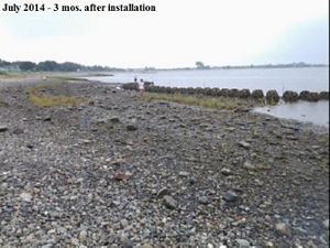
July 2014: The reef marsh showed progress three months after initial installation. © Jennifer Mattei
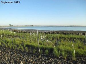
September 2015: The reef marsh had expanded by September 2015. © Jennifer Mattei
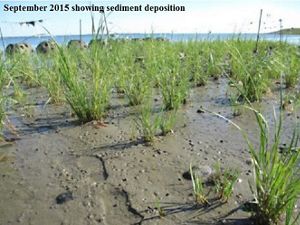
September 2015: 2015 monitoring showed the deposition of sediment in the reef marsh. © Jennifer Mattei
September 2016: Two years after initial installation, the reef marsh showed significant growth. © Jennifer Mattei
September 2017: Four years after installation of the reef marsh, the Stratford Point living shoreline was thriving. © Jennifer Mattei
August 2017: Three years after initial restoration, the marsh grasses were significantly expanding. © Jennifer Mattei
August 2017: The marsh grasses and habitat continued to expand. © Jennifer Mattei
September 2018: The Spartina alterniflora were flourishing, creating new habitat for wildlife. © Jennifer Mattei
September 2019: The living shoreline continued to grow and expand. © Jennifer Mattei
September 2020: The reef marsh showed significant growth six years after restoration began. © Jennifer Mattei
The chart below shows the mean number of Spartina alterniflora stems per m2 (+ 1 SD) in the high intertidal zone at three locations during the summers of 2015–2020. Milford is a reference marsh located at Milford Point, across the mouth of the Housatonic River from the project area in Stratford. Old Reef is the restored marsh area at Stratford Point planted in 2014–2015 behind the pilot reef ball installation. New Reef is the restored marsh area at Stratford Point planted in 2017 behind the latest reef ball installation.

Over the course of the 2019 growing season and through the winter of 2021, the shell-filled coir log that was installed as part of maintenance efforts has remained stable and has secured the toe of the artificial dune slope and underlying geotubes. The native beach grass and switchgrass plugs that were planted on the face of the dune have survived and are growing as of August 2021.
Monitoring the Living Shoreline


Maintenance
All restoration projects require maintenance and management. During the first month after planting Spartina plugs, approximately 10% washed up on the beach and needed to be replanted. The reef balls froze during a harsh winter in 2015, and only a few oysters survived that winter. A few of the seven-year-old reef balls have begun to break down; however, this was expected. The oysters still colonize the broken cement pieces and have begun to build a natural oyster reef.
The most challenging problem at this site is erosion that occurs along the high tide line during winter storm events. In July 2019, additional efforts were implemented on approximately 75 linear feet of the existing shoreline to further stabilize the shell and soil cover that had been deposited to cover exposed geotubes. These efforts consisted of placing an innovative Shell-filled Coir Log® on the planting bench at the toe of the dune (above the Coastal Jurisdiction Line) and then covering the shell and soil with Biodegradable Ecosystem Engineering Elements (BESE-elements®). BESE-elements® are three-dimensional lattice structures made of potato starch. They are used for habitat improvement, serve as a starting point for ecosystem restoration and are considered a biodegradable alternative to plastic geocells. BESE-elements® are purported to increase the tensile strength of sediments and soils, reduce the impacts of local currents and wave forces and provide stability and structure for vegetation and other organisms to become established. Native beach-grass (Ammophila breviligulata) and switchgrass (Panicum virgatum) were subsequently planted on the face of the dune, through the BESE-elements® and in other areas.
Conclusion
Monitoring continues to demonstrate that the living shoreline project has reduced erosion and increased fine-grained sediment deposition throughout the intertidal zone. Structural protection from wave forces has allowed the low-elevation intertidal marsh, consisting of smooth cordgrass (Spartina alterniflora), to mature and provide critical foraging, spawning and nursery habitat. The increased density and stem height of the vegetation have also further enhanced sediment deposition, resulting in a positive feedback loop that is accelerating ecosystem development. A stable population of Eastern oyster (Crassostrea virginica) is also becoming established as a result of structural habitat provided by the living shoreline and protection from erosive wave forces. A natural bed of oysters is developing landward of the old reef on top of oyster shell that was placed at the toe of the old dune, some of which washed out into the mean tide area.
The multiple estuarine habitats created by the living shoreline also provide critical resources to long-legged waders and migratory shorebird species that forage on-site. Shorebirds predominantly use the area as a migratory stop-over site to forage and roost. Several species of long-legged waders that are of conservation priority forage regularly at Stratford Point, including great egret (Threatened, CT-ESA), snowy egret (Threatened, CT-ESA) and yellow-crowned night-heron (Special Concern, CT-ESA). Changes in the conditions of the low-energy beach over the past two years have also spurred nesting activity in horseshoe crabs (Limulus polyphemus), an ancient invertebrate whose populations are declining across their range.
Overall, the findings demonstrate that the project is stabilizing and enhancing approximately 900 linear feet of shoreline, though some areas remain dynamic (along the high tide line), which may limit the future establishment of high marsh vegetation. Future monitoring will continue to evaluate these conditions; corrective actions will be taken as necessary.


The Stratford Point Living Shoreline is an outstanding example of how to work with nature to solve some of our most difficult human-caused coastal degradation problems. It has been used as a model for successful coastal habitat restoration for New England and mid-Atlantic States. This project has clearly demonstrated the importance of living breakwaters, i.e., shellfish reefs, in the protection of newly restored saltmarsh. It has also demonstrated that as sea level rises and the duration of storms increases, the shellfish reef buys time for marsh growth expansion and migration to occur.
The Stratford Point Living Shoreline has already been used as a model for a restoration project along Sherman Creek, Inwood section of Manhattan’s East River, and is being considered as a model to help salt marsh restoration at Edith G. Read Wildlife Sanctuary in Rye, New York, where marsh and dune plantings have been unsuccessful due to winter storm events.
Key Takeaways
Living shorelines are a relatively new approach to erosion control issues along New England's coast. Lessons learned, relevant information and key takeaways from each phase of the projects are presented below for future projects to consider:
Design and Permitting
- Projects that could impact valuable natural resource areas seaward of the shoreline (intertidal or subtidal) require extensive permitting review. Project proponents should reach out to permit issuing agencies—such as the Army Corps of Engineers, state departments of environmental protection, and local conservation boards—to socialize and take in feedback via pre-application meetings. These can grow understanding of what's needed to receive a permit and improve design plans. To meet permitting requirements, additional resources may need to be created, and it is critical to have a good understanding of those needs prior to sourcing funding, so that a realistic budget can be developed.
Construction, Maintenance and Monitoring
- When planning, it is important to remember that environmental conditions, particularly working in, near, or on the water can be unpredictable and can impact construction processes and timelines.
- Environmental conditions can lead to the need for necessary maintenance on living shorelines projects, as well as make that maintenance more challenging to complete.
- Permitting applicants should propose the installation of fixed photo stations that can provide monitoring photos for a period of five years; these stations can be very simple and can lower costs over the last two years. The five-year photo plan should be in addition to three years of more detailed monitoring of specific parameters, as applicable, such as plant density, stem height, areal extent, oyster growth, etc.
Stakeholder Engagement
- Engaging stakeholders via outreach and education can improve the process and encourage community-buy in.
Overall, these projects helped show the viability of different living shoreline types in the Northeast and provided critical knowledge about the best practices for design, permitting, construction and maintenance. This will help advance the policy and practice of these types of nature-based solutions for coastal communities moving forward. In the years to come, this initiative will continue to improve the understanding of living shorelines impacts and performance, improve the regulatory framework, and drive demand for living shorelines that can appropriately increase coastal resilience while providing benefits to people and nature.
Looking for an overview of these projects?
To learn more about what makes a living shoreline and for an introduction to these five projects, check out our story on New England Living Shorelines.