NASA, Partners Launch Innovative Data-Gathering Campaign to Help Protect One of the Most Biodiverse Environments in the World
Media Contacts
-
Heather Gately
Media Contact
The Nature Conservancy
Phone: 773-474-4500
Email: heather.gately@tnc.org
Data will inform future NASA efforts and research and provide partners like The Nature Conservancy with deeper understanding of how the changing climate has and will impact the natural landscape and ecosystem in California and beyond.
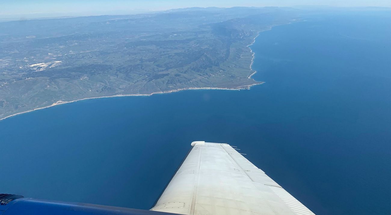
As the impacts of climate change continue to accelerate, NASA Jet Propulsion Laboratory (JPL)'s Surface Biology and Geology (SBG) team, along with The Nature Conservancy’s Point Conception Institute in California and the University of California at Santa Barbara (UCSB), just launched an innovative, large-scale campaign to gather critical data in a region of Santa Barbara County that is one of the most biodiverse and dynamic land and marine environments in the world.
The SBG High-Frequency Time Series (SHIFT) campaign will combine the power of airborne remote imaging to efficiently collect large amounts of data over broad geographic areas with the investigatory depth of field sampling and teams of researchers on the ground to help conservationists, scientists, policymakers and educators get a rare look at how rapidly this diverse group of ecosystems react to the impacts of climate change. This integrated data approach will also serve as a foundation for and help inform future SBG research and efforts.
“It’s exciting to advance our understanding of the methodology and assess how useful the data will be for managing our vulnerable ecosystems,” said David Schimel, JPL research scientist and SHIFT’s principal investigator. “SHIFT does both at once without compromising either.”
The campaign will generate the most precise, high-frequency data on plant communities ever collected over such a vast region and will cover nearly 640 square miles (1,656 square kilometers) across Santa Barbara County, including The Nature Conservancy’s Jack and Laura Dangermond Preserve, UCSB’s Sedgwick Reserve, the Point Conception Marine Reserve Area, the Los Padres National Forest and much of the agriculture-dominated Santa Ynez Valley.
“This landscape has gradually changed over time, and now with the twin crises of biodiversity loss and climate change, change is happening much more rapidly,” said Mark Reynolds, a SHIFT co-investigator and director of the Point Conception Institute at The Nature Conservancy’s Jack and Laura Dangermond Preserve. “This is what it’s about: to understand the change that’s happening, anticipate the change to come and to influence the trajectory of conservation, now and for future generations.”
SHIFT employs an aircraft carrying an imaging spectrometer called AVIRIS-NG (Airborne Visible-Infrared Imaging Spectrometer-Next Generation) that was designed at JPL in Southern California. It works by collecting subtle characteristics of the light reflected from 50-by-50-foot (15-by-15-meter) squares of the surface, which can tell researchers traits of tree leaves, blades of grass, shrubs, kelp and other plants. Successive scans can detect variations in the color of the light and how it reflects, revealing changes in how plants are functioning.
Starting in late February and continuing through the end of May, AVIRIS-NG has been flying over the region once per week. Within about three days of each flight, field researchers collect and analyze samples on the ground and from the ocean to validate data from AVIRIS-NG and perform deeper analyses.
“SHIFT is going to deliver useful information for resource managers, conservation stewards, biodiversity stewards and many others,” said Frank Davis, director of the La Kretz Research Center at the Sedgwick Reserve and a SHIFT co-investigator. “It’s not just a scientist’s sandbox.”
The high-frequency spectral data collected as part of the campaign will give researchers a perspective on the patterns and dynamics of biodiversity in the study area that they can’t see through annual or seasonal scans. This will enhance researchers’ knowledge of the functional traits of plant communities and how they are changing over time—insights that could prove crucial as organizations and agencies make decisions on conservation, land management, agriculture and commerce. The data will also help broaden the basic scientific understanding of these ecosystems and help scientists develop the best approaches to collecting plant data remotely.
The Nature Conservancy is a global conservation organization dedicated to conserving the lands and waters on which all life depends. Guided by science, we create innovative, on-the-ground solutions to our world’s toughest challenges so that nature and people can thrive together. We are tackling climate change, conserving lands, waters and oceans at an unprecedented scale, providing food and water sustainably and helping make cities more resilient. The Nature Conservancy is working to make a lasting difference around the world in 81 countries and territories (40 by direct conservation impact and 41 through partners) through a collaborative approach that engages local communities, governments, the private sector, and other partners. To learn more, visit nature.org or follow @nature_press on X.


