Places We Protect

Black Mesa State Park & Nature Preserve

Oklahoma

Looking down from the top of the mesa.
Black Mesa Nature Preserve Overlooking the expanse of the great plains from atop the highest point in Oklahoma. © Kim Baker/Oklahoma Tourism

Black Mesa is the highest point in Oklahoma at 4,973 feet above sea level.

Overview

Description

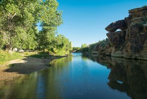
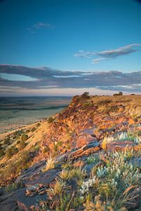
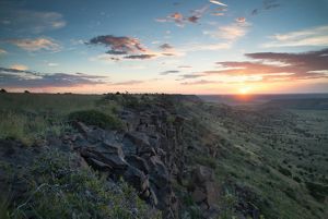
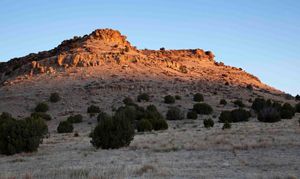
Black Mesa State Park and Nature Preserve is located in Oklahoma's panhandle along the tri-state border with Colorado, New Mexico and Texas. Black Mesa takes its name from the layer of black lava rock that coated the mesa about 30 million years ago. Visitors to the preserve can hike to the top of the plateau, Oklahoma's highest point at 4,973 feet above sea level.

The Black Mesa area supports 31 state rare species; 23 plants and eight animals. Here, the Rocky Mountains meet the shortgrass prairie, a unique area where many species are at the easternmost or westernmost portions of their range.

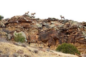
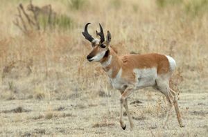
Black Mesa is a birder's paradise any time of the year. Golden eagles, scaled quail, black-billed magpies and pinyon jays are just a few of the birds that may be observed. Black bear, bobcat, mountain lion, mule deer, bighorn sheep and antelope are some of the mammals you might also spot while hiking around.
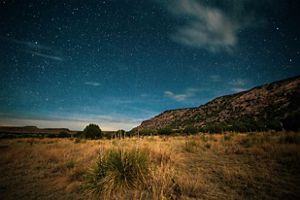
Dark Night Sky

In addition to being an excellent location for wildlife watching, Black Mesa boasts some of the darkest nighttime skies on publicly accessible land in the country. The dark skies draw countless astronomy enthusiasts every year for ideal star gazing conditions, most especially, in August when the annual Perseid meteor shower is visible.

Access

OPEN TO THE PUBLIC

Owned and operated by the Oklahoma Tourism and Recreation Department

Hours

Open dawn to dusk

Highlights

Highest point in Oklahoma, Birdwatching, Hiking, Big horn sheep, Perseid meteor shower, Camping at the State Park

Size

1,660

Explore our work in Oklahoma

Photos from Black Mesa

Discover the wildlife and diversity across the southern high plains. Tag @conserve_ok on Instagram with your mesa pics when you visit.

Bighorn sheep climbing on the rocks.
Directional monument showcasing the tri-state border with Colorado, New Mexico and Texas.
PLACEHOLDER
Sun setting on the mesa.
PLACEHOLDER
Marker noting the highest point in Oklahoma at 4,973 feet above sea level.
Sun setting on the mesa.
Black Mesa trailhead
Pronghorn deer roaming the mesa.
Stars emerging above the mesa at Black Mesa State Park and Nature Preserve.

Visit

  • North about 15 miles from the Black Mesa State Park. From 209th West Avenue (Prue Road) and Highway 64 / 412 exit - Travel north along Prue Road approximately 2 miles. The entrance is directly across from the second cell phone tower and features a large sandstone and black iron gate.

    Click here for a map.

    For more information, call 1-800-654-8240 or visit the Oklahoma State Parks web site.

  • Open every day, dawn to dusk


  • To the Highest Point in Oklahoma

    • Allow at least four hours to walk from the parking area to the top of the mesa and back.
    • A restroom is available at the nature preserve trailhead.
    • Although camping is allowed within the state park, no camping is allowed within the nature preserve borders.
    • Hikers need to be prepared for high temperatures during the summer and are advised to bring plenty of water.
    • Located about 15 miles from the nature preserve, Black Mesa State Park is adjacent to Lake Carl Etling and offers RV and tent campsites, picnic facilities, boat ramps, trout fishing in season, a playground, restrooms with showers and a group camp with 12 bunkhouses. Approximately 36 RV sites with water and electric hookups and 23 tent sites are available on a first come, first serve basis at Black Mesa State Park.
Catus at the JE Canyon in Colorado.
JE Canyon Cactus JE Canyon, Storage Tank Burn Unit, in Las Animas County 50 miles northeast of Trinidad, Colorado. In February 2017, The Nature Conservancy's Southern Rockies Wildland Fire Module (based In Colorado) traveled to south eastern Colorado near the town of Branson to do prescribed burns in the short grass prairies and pinion juniper savannah. Burn unit was approximately 200 acres and intended to reduce woody material encroacing on the prairies and promote regeneration of native species in this historically fire adapted ecosystem. Contact the Colorado Chapter of The Nature Conservancy for more information. © Jason Houston

Southern High Plains Initiative

When you talk to people who have devoted their careers to conserving grasslands, you’ll immediately sense their passion—and you’ll start looking closer at the little things in nature.

“Those high plains, the short grass, big vistas, mesas in the distance. People should spend more time there, in that quiet, windy place, and they would see the beauty in it,” says Katie Gillies, TNC’s Director of Conservation in Oklahoma.  

At the intersection of five western states—Colorado, Kansas, New Mexico, Oklahoma, and Texas—lies one of the largest opportunities for grassland conservation in the country: the Southern High Plains. 

Read more about this initiative.

Find More Places We Protect

The Nature Conservancy owns nearly 1,500 preserves covering more than 2.5 million acres across all 50 states. These lands protect wildlife and natural systems, serve as living laboratories for innovative science and connect people to the natural world.

See the Complete Map

Support High Plains Conservation in Oklahoma

Show your Okie pride by sporting a speciality license plate on your car or make a donation to continue conservation efforts across the state.