

New Hampshire’s rivers and streams once flowed freely, uninterrupted, to the edge of the sea. Today these waterways are choked by more than 2,600 aging dams and 15,000 culverts. River herring and shad no longer return home to spawn, and brook trout struggle to reach cool headwaters. Every storm generates polluted run-off that spills into our waterways. Habitat degradation threatens intact floodplains and the drinking water vital to community health and sustainability. The recent droughts are ominous reminders—we can’t take our freshwater for granted.

The water we depend on depends on us. That's why New Hampshire's Freshwater Program is designed to meet these challenges head-on, ramping up efforts to restore and reconnect our rivers and streams, conserve our critical floodplains, and protect our precious drinking water. Together with our partners, we are currently working across the Granite State to chart a course for healthy waterways using science-based plans for on-the-ground work that benefits people and nature.
1: Restoring River Flows
Did you know that removing a dam can create better recreational opportunities, enhance the ability of fish to move freely up and down stream, improve water quality, and help reduce flood risks? Removing dams also benefits coldwater species like brook trout. Our changing climate is causing warming waters and more frequent droughts, but reconnecting our rivers and streams will help them survive, reproduce and thrive into the future.
There are nearly 3,000 of these manmade barriers disconnecting our waterways across the Granite State. Many are relics of a bygone era, serving no useful purpose except to create undesirable impacts such as blocked fish passage, warming our waters, habitat loss and safety hazards.
We are working to unlock the funding and technical expertise to make dam removal accessible to any individual or community ready to re-connect its waters. Oftentimes, dam removal is generally cheaper than repairing and maintaining old dams indefinitely, and restoration projects can have a positive economic and social impacts.
Happening Now
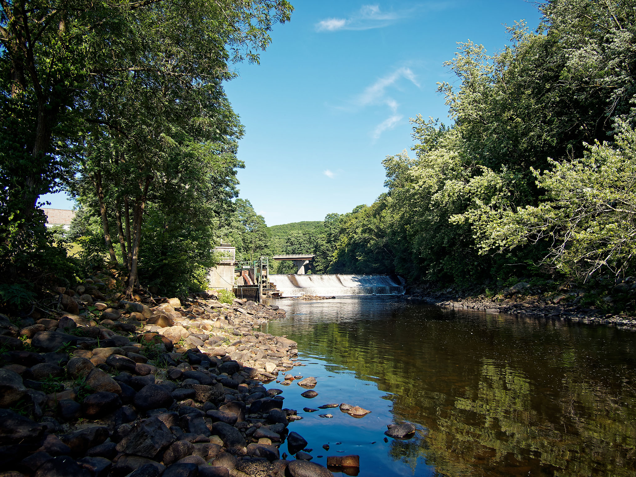
Fiske Mill Dam in Hinsdale
We recently became the owners of the Fiske Mill Dam, which sits 15 miles southwest of Keene on the Ashuelot River just above where it meets the mighty Connecticut River, and we have big plans to remove it. Building upon the successful removal of three other dams on the Ashuelot, the removal of Fiske Mill Dam—coupled with the installation of fish passage at two dams immediately upstream—will reconnect 234 miles of river and stream habitat for migratory fish, resident fish and freshwater mussels.
This project benefits people too, because who doesn't love going canoeing or kayaking on a river? We'll work together with the community to reimagine the space surrounding the dam site to enhance recreational access and quality of life for those who live, work and play in town.
See how we're working with the community to reconnect the Ashuelot River.
Dam removal can be an important tool in freshwater conservation. With a free-flowing river, we’re going to see improved water quality for people and native biodiversity survival.

2: Ensuring Healthy Waterways for All
The water we use is directly dependent on the landscapes it flows through. By conserving watersheds—the lands around rivers, lakes and streams—we protect the services that these systems provide. Removing restrictions and upgrading road-stream crossings will enhance public safety while also improving water quality, wildlife habitat, fish passage and coastal resilience. Meanwhile, we must work with our policy makers to advance effective freshwater policy that is informed by the best science available today. Only public policy combined with private and public conservation will effectively address the sustainability of our freshwater future.
Together with communities and partners, TNC’s vision is to conserve New Hampshire’s iconic watersheds so that we can improve water security, enhance communities’ ability to adapt to climate change, promote equitable, inclusive development and restore ecosystems into the future.
Restoring Flow and Connection
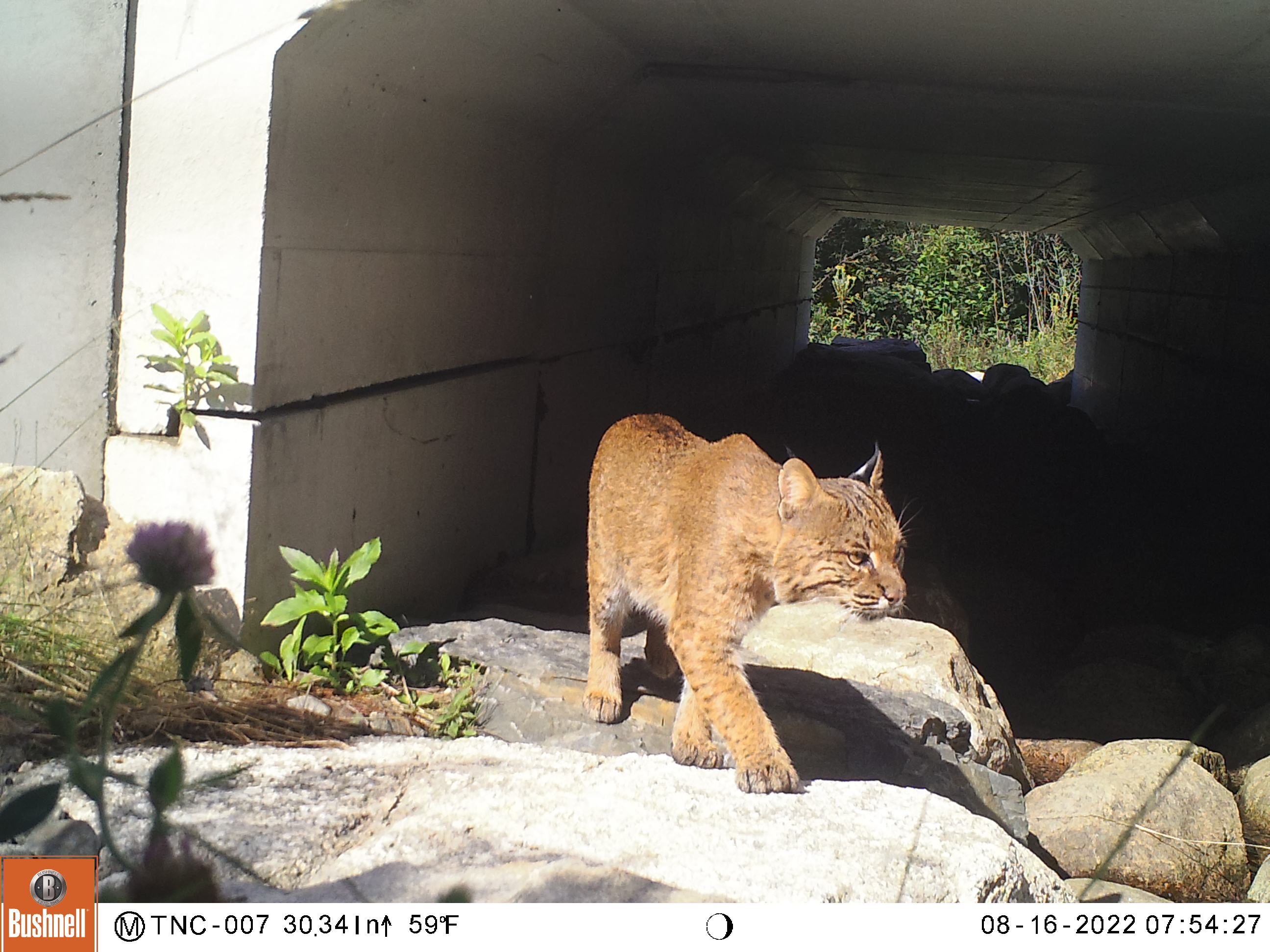
The Otterway: Helping Water, Wildlife and People, Too
On a stretch of Route 3 in northern New Hampshire, a small, aging culvert was causing a big problem. It blocked fish from reaching upstream habitat and forced wildlife to make a dangerous choice: attempt to cross the road or turn back.
Working with the New Hampshire Department of Transportation and New Hampshire Fish and Game Department, we helped replace the outdated structure with a right-sized crossing that works with the river, not against it. The new box culvert (affectionately nicknamed "the Otterway") restores natural stream flow and reconnects miles of habitat for species like brook trout. Just as important, it includes a dry passage that gives animals from otter to bobcat a safe route beneath the road instead of across it.
The result is a smarter kind of infrastructure; one that reduces the chance of wildlife-vehicle collisions while helping the river and surrounding habitat function the way they should.
See how the Otterway is making roads safer and reconnecting habitat.
Building a More Resilient Neighborhood
Creating Safe Passage Along Topaz Drive in Barrington
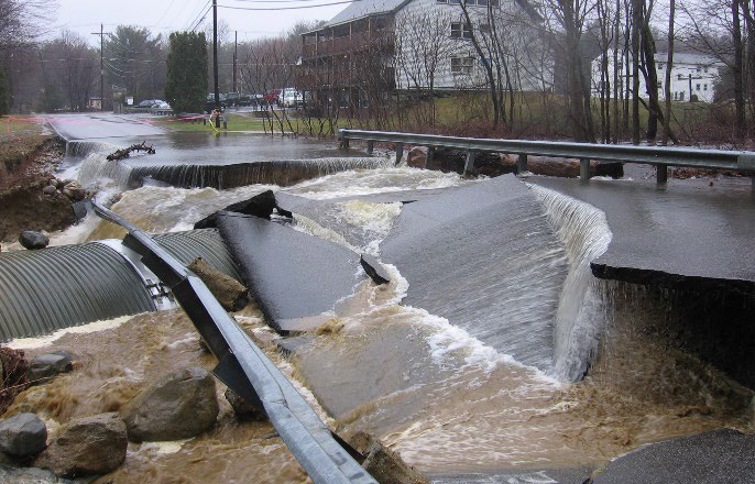
Located in Barrington, Topaz Drive is the only road in and out of Emerald Acres Cooperative, a residential community of about 100 homes. The road crosses over the Oyster River using an undersized culvert that is prone to flooding. During the Patriots' Day storm in 2007, the road washed out completely, isolating the community for three days. Protecting this neighborhood from future flooding events like this is why we worked together with the community, town and state to redesign and replace the culvert with a 32-foot bridge.
This new bridge reduces the flood vulnerability along Topaz Drive, ensuring the road remains safe and reliable for people as our climate changes and more severe storms occur. Meanwhile, it also restores free flow to the stream beneath. Before the replacement, most fish couldn’t move upstream past the culvert, including American brook trout and American eel. New Hampshire Fish and Game identified Topaz Drive as the #1 culvert in need of replacement in the entire watershed, noting that the Oyster River watershed has the only known occurrence of American brook lamprey in New Hampshire—a state endangered, critically imperiled species. The improved under-road passage enhances fish passage by allowing fish like the lamprey to move freely above and below the new structure.
Replacing the culvert is also great for wildlife connectivity. Various wildlife species, including Blanding’s and spotted turtles, benefit from the increased access to move freely under the road—making this project a triple win!
The importance of this project is underscored by the critical funding it received from a variety of supporters, including the Aquatic Resource Mitigation Fund, the New Hampshire Department of Environmental Service's Critical Flood Risk Infrastructure Fund, a NHDES Watershed Assistance Grant, the New Hampshire Moose Plate Program and a matching grant made by Emerald Acres Cooperative.
Check out adaptation at work and dive deeper into this project.
Happening Now
Building Coastal Resilience in North Hampton
We are working with the Town of North Hampton to retrofit a priority tidal crossing to restore more natural tidal flows to Philbrick Pond. Situated on the western side of Ocean Boulevard (Route 1A), the pond is just a stone’s throw from the Atlantic Ocean, connected by Chapel Brook, a tidal waterway that runs under the road through an old stone box culvert. The area is prone to extensive flooding during severe storm events. During the Mother’s Day floods in 2006, more than 40 homes were cut off from evacuation routes and emergency services for more than three days.
The installation of the new, properly sized culvert has allowed for the return of the natural highs and lows as water flows in and out of the pond with the tides. The tidal crossing can also better mitigate flooding during storm events, providing safer passage for people traveling the roadway.
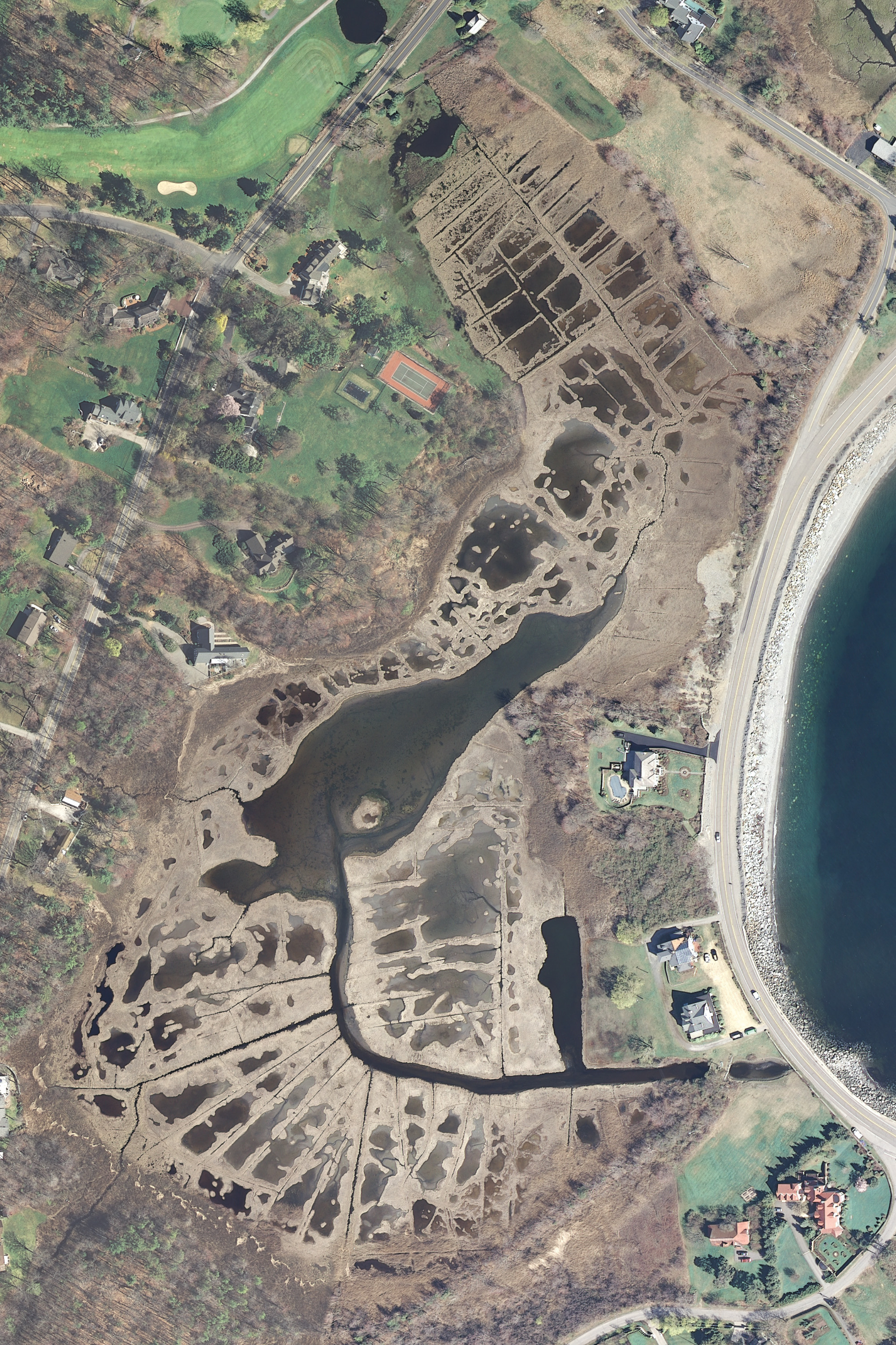
We are also launching a salt marsh restoration planning effort at Philbrick Pond that will incorporate innovative and promising restoration approaches that have yet to be attempted in New Hampshire. This exciting work will address historic ditching and agricultural practices that result in the collapse (die-off) of the salt marsh habitat. “The Philbrick Pond salt marsh is essentially drowning as a result of all the manipulations that occurred there over the last 300 years," says Pete Steckler, formerly of The Nature Conservancy and principal and professional lead for Northeast Conservation Services. "It’s like syrup on a waffle—the salt marsh is the waffle, and the water is the syrup with nowhere to go.”
Due to these past agricultural practices, Philbrick Pond is among the most severely impacted salt marsh systems in the Northeast and offers an amazing opportunity to trial—and potentially scale up—these new restoration approaches. A pilot of the restoration plan is set to begin in spring 2023.
The many funders of this work are a testament to its importance: The National Oceanic and Atmospheric Administration, NHDES (through both its Coastal Program and a Watershed Assistance Grant), the U.S. Environmental Protection Agency, the NH State Conservation Committee Conservation Moose Plate Grant Program, the Lafferty Family Charitable Foundation and The Nature Conservancy all contributed much-needed dollars to finance the project.
Upgrading New Hampshire's culverts and restoring our road-stream crossings benefit nature, people, and cost-effectiveness. There’s a triple bottom line.
3: Reviving River Corridors with People, for People (and Nature Too!)
We don’t often think of the land around a river as part of the river itself, but these corridors or “meander zones” are a critical piece of the river’s dynamic system. Historically, we have developed in these river routes, and oftentimes, the most vulnerable Granite Staters reside in these high-risk river corridors.
Protecting river corridors reduces flood damage by helping rivers reconnect to their floodplains, thereby storing more water during flood events, and decreasing damage to flood-vulnerable structures, our transportation networks and other investments.
As we adapt to the severity of weather events, we need to act to protect those most at risk to flooding while working with nature to increase flood and climate resilience. Protected river corridors would slow the corrosive energy of flood events and minimize impacts downstream, better safeguarding people and our communities as our climate changes.
Happening Now
Merrimack River: A Shared Vision for a Healthier Watershed
The Merrimack River flows through the heart of New Hampshire’s largest cities and supports more than a million people across the region. It’s also one of New England’s most challenged watersheds, shaped by a long industrial history and now facing pressures from climate change, flooding and limited access to nature in urban communities.
The Nature Conservancy in New Hampshire and Massachusetts are working with the Merrimack Conservation Partnership and local communities to create a more connected, climate-resilient watershed: one that supports both people and nature. A key part of this effort is the updated Merrimack Watershed Conservation Plan, which now expands beyond traditional land conservation to include solutions in developed areas. The plan reflects input from local residents and partners and helps guide where conservation, restoration and nature-based projects can have the greatest impact.
Together, these efforts are helping to improve water quality, reduce flood risks, restore habitat and expand access to green space, especially in the communities that need it most.
Explore how communities are shaping the future of the Merrimack River.

We approached the planning process as a sustained dialogue with Merrimack River communities to ensure we had all perspectives included… It also means expanding our definition of what we consider expertise.
4: Focusing on the Future of Floodplains
Floodplains, the low-lying areas adjacent to our rivers, are one of nature’s secret weapons, acting as sponges to slow, filter, and clean our waters. This “nature-based solution” is the key solution to some of our freshwater challenges.
Because our rivers have been straightened and divorced from their floodplains, New Hampshire’s rivers carry more nutrients and sediments and flow faster and more forcefully, contributing to more serious flooding and poor water quality—an accelerating issue due to climate change.
Investments in nature are cost-effective and have multiple benefits. Not only does floodplain protection and restoration improve flood resiliency and water quality, it increases carbon storage and conserves critical fish and wildlife habitats.
Happening Now
Re-planting Floodplains in Northern New Hampshire
Thanks to the addition of 760 acres of woods, farmland and wetlands, the expanded Maidstone Bends Preserve—located along the twisting curves of the Upper Connecticut River in Groveton, New Hampshire—protects drinking water for nearby communities. It also helps link a network of conserved lands across the Northern Appalachians.
Now we're working to restore more than 200 acres of floodplain forest habitat at the preserve. Over the next five to 10 years, TNC will partner with nurseries to grow thousands of native trees and shrubs, which staff and volunteers will plant in the areas most vulnerable to flooding. If the project is successful, it will be the largest active floodplain restoration project in the history of New England.
Most active floodplains have been converted to other land uses, but we know these places protect water quality, help attenuate floods and provide important wildlife habitat.
We can’t save New Hampshire’s waters without you.
Sign up to receive monthly conservation news and updates from New Hampshire. Get a preview of New Hampshire's Nature News email.

New Hampshire Stories

New Hampshire's Ocean and Coasts
Discover How Collaboration and Natural Solutions Are Safeguarding our Coastal Waters

What Happens at a New Hampshire Nature Preserve?
As countries race to protect at least 30% of Earth’s remaining intact ecosystems, see three ways local stewards manage New Hampshire's existing protected areas.

Our History of Conservation in New Hampshire
From the Northwoods to the Seacoast to the Connecticut River, TNC is working to sustain people and nature throughout the Granite State.