Engineering Natural Solutions on the Mississippi
Working with existing structures, experts are restoring natural function throughout the river basin.

Old tools, new uses
Sometimes finding the best way forward requires taking a new perspective. Inspired by Aldo Leopold’s idea of using old tools in new ways, The Nature Conservancy (TNC) and partners are reimagining the tools that altered our great rivers—locks and dams and levees—to help them regain more natural functions and resilience.
Leopold’s theory that wildlife can be restored by the creative use of the same tools that destroyed it—axe, plow, cow, fire and gun—continues to inform conservation practices today. Our large rivers have been similarly altered, and conservationists are once again looking to the same tools that caused harm for solutions.
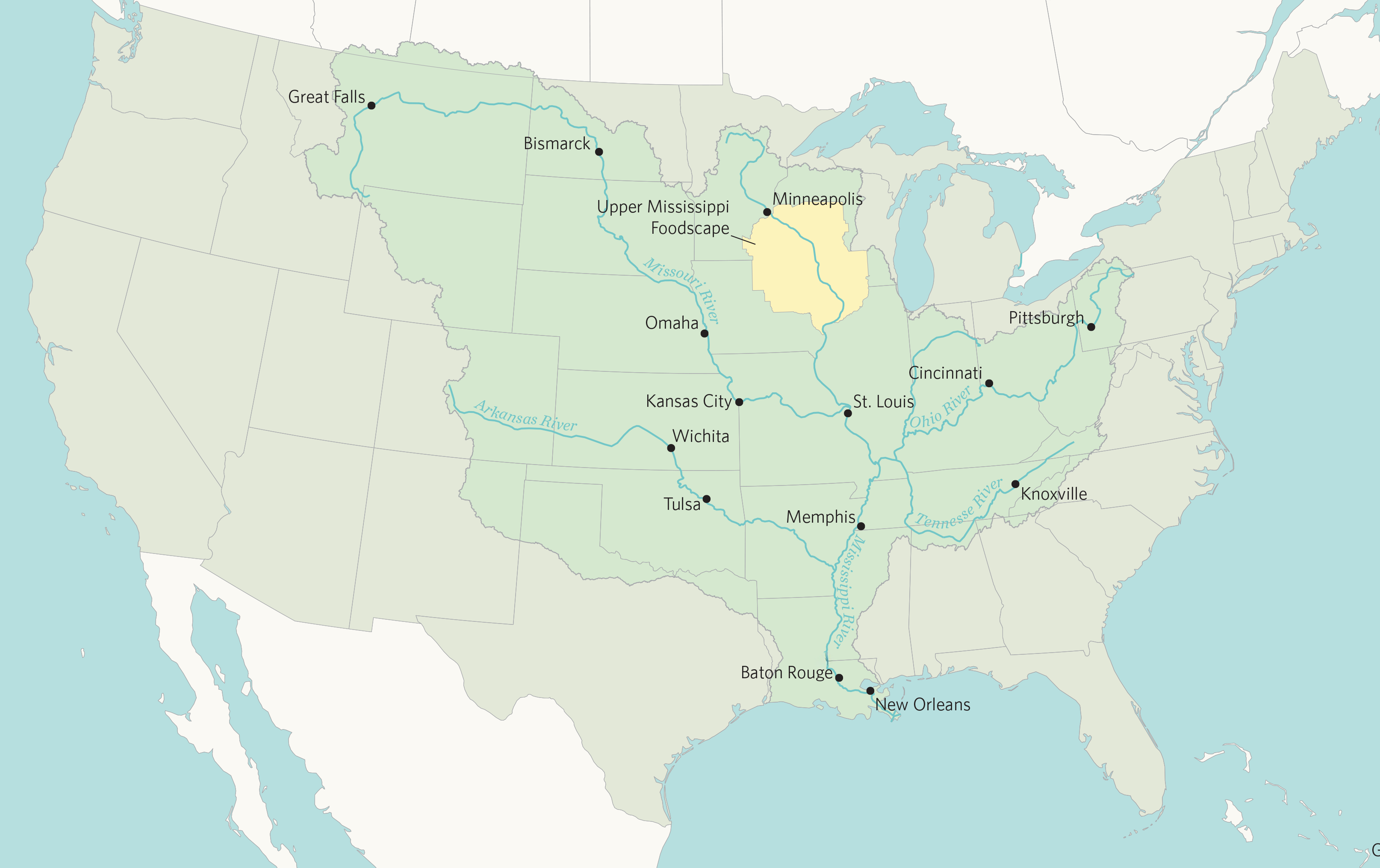
The Mississippi River basin spans 40% of the U.S., connecting major tributaries like the Arkansas, Illinois, Missouri, Ohio and Red rivers. A river system this vast requires coordination across state lines and with multiple government entities. No single organization can manage a system at this scale.
The largest water management entity in the U.S. is the Army Corps of Engineers. The Corps has managed rivers for more than a century to aid navigation—a significant economic driver that transports more than 500 million tons of freight annually. To ensure barges can travel through the network of rivers, the Corps dredges the river to maintain a minimum depth and has installed locks and dams throughout the system to help barges navigate through changing water levels. But all of this comes at a cost.

Bridge over a river with construction cranes under blue skies.
A river system forever changed
These interventions on major rivers have unintended consequences. The dams used to manage water levels for navigation slow the river’s flow, creating lake-like conditions that degrade habitat, hinder fish migration and disrupt natural flood cycles. Over time, these changes reduced water quality and fragmented wildlife habitat. And changes on the land also impact the rivers.
“We have altered our landscape significantly. We developed the land, planted row crops and straightened streams—and our large rivers are on the receiving end of all those impacts,” said Bryan Hopkins, TNC Midwest strategy director of great rivers and floodplains. “We’re past the point of letting the river heal itself. We really need to engineer back the functions that provide environmental benefits.”
Richard Raynie, a project manager with the Corps in New Orleans, agrees. He’s worked with the river in Louisiana for 30 years, the bulk of that time spent with the state’s Coastal Protection and Restoration Authority.
“We have to look at the river as a system. It’s a different river system than it was more than 100 years ago, and a lot of ecosystem changes have resulted,” Raynie said. He explained that water control is different in the lower basin where there aren’t locks and dams but more levees. “It’s a less controlled system, so we’re reacting to the water more than controlling it.”
Quote: Bryan Hopkins
We’re past the point of letting the river heal itself. We really need to engineer back the functions that provide environmental benefits.
A new paradigm
In most cases, we can’t remove the dams on large rivers, but we can change how water moves through them. By blending engineered infrastructure with natural features like wetlands, islands and floodplains, we can restore critical functions while maintaining navigation and flood protection.
Today, the same agency that built the dams and levees is a key partner in reconnecting floodplains, rebuilding habitat and making communities more resilient.
“One mission of the Corps is navigation, but equally important now is our aquatic ecosystem restoration mission,” said Jill Bathke, a water resource planner with the Corps. “In the last 15 years, the Corps has focused on ways to reestablish a self-regulating system. We’ve shifted the way we manage the system. We are required to think about natural solutions and to think 50 years into the future to make sure the solutions are sustainable.”


In the lower river, sand dams provide an example of balancing flood control and ecosystem restoration, Raynie explained. Sand dams, a type of temporary levee, help keep water in the river, maintaining the stream power during low levels. During high water, the sand can be distributed in the adjacent wetlands in the delta, helping to restore habitat.
“That’s a key hybrid project that has benefits to both navigation and ecosystem restoration. So the Corps is contemplating multi-faceted solutions, looking at not only navigation and flood risk mitigation, but also ecosystem restoration,” Raynie said.
Partnering to create a resilient Mississippi River basin
Large-scale solutions require massive resources. Partnering with federal agencies like the Corps enables the necessary projects to restore a resilient river basin. TNC builds strong relationships with the Corps at all levels to align local and national priorities. This partnership allows TNC to bring science, data and community input to projects at a basin-level scale, and this additional insight helps the Corps make thoughtful decisions.
“Partnering with organizations like TNC and academic institutions helps add credibility and scientific understanding of the effects of water control structures and how we operate them,” Raynie said. “That specialized knowledge helps us understand the impacts, and it really helps us to have that perspective.”
TNC has a long history of partnering with the Corps to make this happen. Together, we’re finding ways to reconnect floodplains, rebuild habitat and improve resilience for both people and nature.
Partnering Around the Basin
TNC partners with many state and federal agencies, including the U.S. Army Corps of Engineers, to coordinate restoration projects throughout the Mississippi River basin.
A tour of restoration projects from the headwaters in Minnesota to the Gulf provides ample examples including planting trees, restoring wetlands, setting back levees to give the river room to roam and reconnecting a 6,000-acre floodplain.
Reconnecting Floodplains on the Lower Wabash River
Near where the Ohio meets the lower Wabash River in Indiana, TNC collaborates wtih farmers to find alternative uses for their frequently flooded land. Together we are reconnecting the floodplains with the river, restoring habitat and allowing floodwater to spread onto the land where sediment containing excess nutrients can filter out of the water before it flows back to the river.
Mimicking Flood Pulse
In central Illinois we have developed two living labs, Emiquon Nature Preserve and Spunky Bottoms, both along the Illinois River, to restore large floodplains and explore innovative floodplain management solutions. Specially constructed water control structures allow us to control the connection with the river and mimic the function of a floodplain flood pulse.
Flooding Solutions in Southern Illinois
Near the confluence of the Ohio and Mississippi Rivers, many farmers face the challenge of repeatedly flooded fields where their properties meet the river. In southern Illinois, this challenge is especially visible at Dogtooth Bend, a flood‑prone peninsula once protected by a vulnerable levee system. When a major flood in 2019 breached the levee, water surged across farmland, carrying barges and debris and dramatically reshaping the landscape. After the waters receded, enormous sand dunes and deep river sediment deposits made farming nearly impossible. With the levee deemed beyond repair, landowners had few viable options. TNC, drawing on its long track record of working with flood‑prone communities along the Mississippi River, extended its support. TNC brought together partners who could offer landowners a new path forward at a time when many felt they could no longer farm. Many sold their properties with the understanding that the land would be restored to natural floodplain habitat—giving the river more room to spread out during high-water events and reducing future flood risk for people and nearby communities.
Levee Setback on the Missouri River
The extreme flooding that northwestern Missouri experienced in the spring of 2019 was devastating to the local communities, businesses and the agriculture industry.
The Missouri River breached more than 100 levees, inundating 1.2 million acres, damaging infrastructure including farms, railroads and Interstate highways and closing approximately 470 roads. Missouri River levee L-536, in Atchison and Holt Counties, was breached in 7 locations alone—and suffered significant damages. With community input, the levee district determined setting back the levee would be the most beneficial solution.
This project shows what can be accomplished through partnership with the Army Corps, landowners and state conservation agencies in a coordinated effort to find solutions that benefit everyone.
Connecting a Large Floodplain in the Delta
In Mississippi, TNC—along with 15 partners—took on the Herculean task of reconnecting the Mississippi River with a 6,000-acre floodplain. The new water control system allows the floodplain to filter 40% of harmful nutrients out of the water before it is returned to the river. This control of the connection enables improved habitat for birds and allows fish to spawn and make their way into the river.
Adjusting Flow to Restore Habitat
When the Red River meets the Mississippi, the fragile Southern Deltas can quickly become overwhelmed by the volume and speed of the water rushing to the Gulf. Old River Control, near the confluence, diverts 30% of the Mississippi to the Atchafalaya River, managing both the volume and speed of water as it makes its final run to the ocean.
TNC is working with the Corps to find alternative management practices at the control that could reap numerous ecological benefits, including protecting the crawfish habitat, which is an important fishery and significant contributor to the economy in the bayou.
“When we are working in large river systems, we can’t make adjustments in one part of a river without affecting others. We have to look at the river systemically,” Hopkins explained. “The Corps conducts large studies that help us look at the whole system and make good decisions.”
Bathke works with the Corps Navigation and Ecosystem Sustainability Program (NESP), which serves the dual purpose of maintaining navigation channels and ensuring sustainable solutions.
“These large studies enable the authority and funding for projects and also help the Corps forecast out where we are going to work and help identify opportunities where there aren’t ecosystem restoration projects in place to realize benefits,” Bathke said.
For example, the Corps uses material dredged from the river to create new ecological benefits like building river islands and berms to support habitat and creating forest diversity that supports tree species important to migratory birds.
“The Mississippi River system flows through three of the most important migratory bird flyways in the world,” says Nick Ohde, TNC’s Mississippi River Basin Program director. “When we manage water to attract migratory birds to the floodplain, it benefits hunters, birdwatchers and wildlife alike.”
Quote: Jill Bathke
In the last 15 years, the Corps has focused on ways to reestablish a self-regulating system. We’ve shifted the way we manage the system.

Remembering Leopold’s words, we can use dams and other structures to manage water levels and mimic the natural function of floodplains. These structures can be used to draw down water for strategic periods of time to expose the mudflats—built-up sediment left behind as the river floods and recedes.
“When we think about healthy, wild rivers, the first thing we think of is probably not dams and levees. But we work with what we have,” said Ohde. “These structures can be really important tools to mimic natural flow patterns of rivers to benefit people and nature.”
Expert use of this ability allows us to mimic the natural pulse of a free-flowing river, which would ebb and flow periodically, exposing its edges for a time, then covering the floodplain again as water levels rise.
Healthy rivers benefit people and nature
“The lock and dam system definitely altered the upper Mississippi River, and it’s changed how we control water levels,” Bathke said. “Our goal is to manage water levels to mimic natural peak and lowering of water levels. Oftentimes that means lowering the water level by just a few inches. This exposes mudflats and allows plants to grow, which can benefit a variety of species that use the river as a migration corridor or as habitat.”
Those mudflats are teeming with life. Creating a pulse of flooding and receding water—just a couple of inches deep—allows seeds to germinate, yielding vegetation that provides food for waterfowl when the plants are exposed in shallow water. Then as the water flows again, those aquatic plants continue to provide food and habitat for myriad freshwater creatures, including macroinvertebrates, which in turn become lunch for fish and migrating birds. Effective use of this pulse allows habitats to evolve, protecting threatened and endangered species, and filters the water, providing communities with a cleaner supply.
“There is so much science and long-term monitoring on the upper Mississippi River that is important to designing sustainable water resource solutions, and we rely on that long-term data to build better projects and support ongoing restoration,” Bathke said.
Sustainable Rivers Program
Throughout the basin, the Sustainable Rivers Program (SRP)—a partnership between TNC and the Corps—helps Corps staff manage dams on smaller rivers and streams for environmental benefits. Together, TNC and the Corps identify areas where small changes in water levels could benefit a particular species of mussel or fish, for example, and work with dam operators to implement the flow change within the operating parameters for that dam.
In Louisiana, the Old River Control Structure keeps the lower Mississippi River in its current channel. Without it, the Mississippi River would change its course and bypass Baton Rouge and New Orleans altogether. Allowing that to happen would have massive economic consequences, so since the 1950s, the Corps has diverted about 30% of the Mississippi River into the Atchafalaya basin. Altering how that 30% is allocated in a small way may deliver big ecosystem benefits. The SRP held a workshop to consider the effects of small changes.
We asked, “If we can turn the knobs differently, what are the impacts?” Raynie said.
We’re collecting data to understand how water flows through the basin and make improvements. For example, holding water on the floodplain a little longer at key times of the year can give fish and crawfish time to spawn, giving a boost to the local fisheries and improving water quality.
“The Atchafalaya River basin is the largest forested wetland in North America and provides critical wildlife habitat, water filtering and flood relief for our communities,” said Bryan Piazza, science director for TNC in Louisiana and the Mississippi River Basin program. “Finding the right balance to protect all of those benefits is key to ensuring this significant resource persists.”
Quote: Richard Raynie

We have to look at the river as a system. It’s a different river system than it was more than 100 years ago, and a lot of ecosystem changes have resulted.
A living laboratory
TNC’s Emiquon Preserve, a 7,000-acre floodplain along the Illinois River in central Illinois, allows staff and partners to better understand how to mimic nature in a controlled environment. A water control structure installed at the connection with the river can let water in and out of the floodplain. Understanding the impacts on both the river and the floodplain is critical to protecting the delicate ecosystem.
“Simply opening an area and allowing water to periodically move into it may appear on the surface to be restoring the function of the river, but we need to ask, is it getting in at the right time of the year, staying for the right length of time for plants to grow and giving the right spawning cues for fish? Emiquon has shown us the need to control how the river is connecting with its floodplain and plan for conservation goals,” Hopkins said.
Emiquon builds on a long history of similar water management projects led by state and federal agencies along the Mississippi River—work that has been refining how infrastructure can support ecological function for decades. Lake Odessa in Iowa was one of the first places on the Mississippi to do that. This large oxbow wetland connected to the Mississippi River is owned by the Corps and managed by Iowa Department of Natural Resources and the U.S. Fish and Wildlife Service. For more than 75 years, state and federal agency staff have used water control structures to try to mimic the river’s natural seasonal pulse.
“I grew up near Lake Odessa,” Ohde said. “It’s easy to take it for granted, but it really is a place where you can see how thoughtful water management can support fish, waterfowl and migratory birds while still working within the reality of how the modern river is managed.”
Quote: Nick Ohde

The Mississippi River is a highly altered system. Just letting a portion of it go back to nature won’t restore a natural system. This is why we work with partners to take a holistic approach to restoring the river system.
A resilient river for the future
Restoring the health of our great rivers isn’t about turning back time. It’s about rethinking the tools we already have. The locks, dams and levees that once straightened and constricted these waterways might also hold the key to restoring some of their natural function.
“The Mississippi River is a highly altered system. Just letting a portion of it go back to nature won’t restore a natural system,” Ohde said. “This is why we work with partners to take a holistic approach to restoring the river system.”
Each of these projects helps TNC and its partners, including the Corps, learn together what works under different conditions so we can identify more ways to help the Mighty Mississippi remain resilient for future generations.
We Can't Save Nature Without You

More stories for you

What is a Floodplain?
(2:36) This short video explains what a floodplain is and why restoration is important to freshwater resiliency.

Sustainable Rivers Program
The Nature Conservancy and the U.S. Army Corps of Engineers are finding new ways to strike a sustainable balance in how people use and protect the many benefits that rivers provide.

Protecting and Restoring Missouri's Rivers
TNC has been working to protect Missouri’s rivers and streams since 1956. With our partners, we’re dedicated to ensuring these irreplaceable resources are available for generations to come.