

Natural Highways and Neighborhoods: Conserving a Network of Climate-Resilient Lands
This remarkable new mapping tool provides a roadmap for conserving places where plants and animals can thrive in a changing climate.
Proceedings of the National Academy of Sciences
Published Feb. 6, 2023: The science behind this work
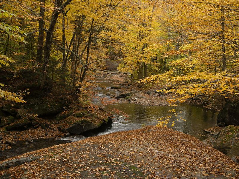
See the Science in PNASAs Jim Shallow, director of strategic conservation initiatives for The Nature Conservancy in Vermont, hiked up Burnt Mountain, he repeatedly stopped to listen to the songbirds. By the time he reached the 2,585-foot peak, he had identified 25 different species based purely on their calls.
From the top, Shallow looked down at the vast stretch of trees below. Burnt Mountain is located amidst a series of public and private conserved lands, creating an 11,000-acre block of unfragmented forests. And while Shallow couldn’t spot them beneath the dense treetops, he knew that an array of wildlife roamed below—including moose, black bear, coyote, bobcat, barred owls and—yes—songbirds.
“This forest is going to be that place where birds and other wildlife will have core habitat that will be resilient to future climate threats,” he said.


Our challenge is to accelerate the pace and scale of conservation and conserve a representative network of resilient, connected lands and waters that will allow nature to adapt to climate change.
A Network of Resilient and Connected Lands
Burnt Mountain has been identified by TNC scientists as part of a network of unique places across the continental United States that can help nature thrive in the face of climate change.
Warmer temperatures, increased flooding and other climate threats are altering and destroying habitat, forcing species to search for new places to live. Studies show that plants and animals are moving 11 miles north and 36 feet higher in elevation each decade in response to the changing climate.
Over the past 10 years, TNC scientists have mapped a network of landscapes across the United States with unique topographies, geologies and other characteristics that can help withstand climate impacts. This roadmap of “natural highways and neighborhoods” shows where plant and animal species have the best chance to move away from growing climate threats and find new places to call home.
This gives us hope that if we work to keep these special places strong, they will keep nature strong.
“This gives us hope that if we work to keep these special places strong, they will keep nature strong,” said Dr. Mark Anderson, TNC’s director of science for the Eastern United States who led the mapping work. “Our challenge is to accelerate the pace and scale of conservation and conserve a representative network of resilient, connected lands and waters that will allow nature to adapt to climate change.”
What Are Natural Highways and Neighborhoods?
Among the things that makes these places special are their diverse physical characteristics—steep slopes, tall mountains, deep ravines, diverse soil types— that create numerous microclimates and allow plants and animals to move around their local “neighborhood” to find suitable habitat where they can escape climate threats. The landscapes also have good connectivity—“natural highways” that allow movement across local microclimates and between climate resilient landscapes.

In addition to providing safe places for nature to thrive, the network of lands also offers benefits to people, including clean drinking water, economic income and carbon storage that fights climate change.
In the case of Burnt Mountain, early estimates suggest that the lands will yield more than 270,000 credits in the first decade (1 credit = 1 metric ton of carbon), an equivalent benefit of removing 38,000 cars from the road. It is Vermont’s largest carbon project to date.
Through a conservation easement and work with partners, TNC is managing Burnt Mountain to ensure it will continue to support both people and nature in the face of climate change.

A Conservation Tool for Land Trusts, Agencies, Communities and Others
TNC’s roadmap of natural highways and neighborhoods covers 33% of the continental U.S. and can bring together government agencies, land trusts, private land owners, Indigenous communities and other stakeholders to develop conservation plans that will help nature thrive on a national scale while meeting local needs.
Among the natural highways and neighborhoods scientists have identified across the United States are:

Monsoon Passage—Nevada to Idaho
Stretching from Lake Meade in the south, up through Great Basin National Park and north to the Jarbidge Mountains near the Idaho border, this natural highway of connected mountain ranges and wet valley bottoms provide desert tortoises, bighorn sheep, Cooper’s hawks, mule deer, golden eagles and other species escape routes from growing climate impacts.
A deep aquifer runs through a substrate of carbonate rocks beneath this 500-mile long passageway, occasionally surfacing as springs in which endemic fish, snails, slugs and insects live. The cool valley bottoms, waterways and wet systems of this area will become increasingly important as climate change leads to higher temperatures and forces animals to seek cooler habitat and sources of drinking water.

The region's name comes from being at the western edge of the summer monsoons that provide eastern-facing moisture to buffer heat and a pathway for species moving north.
TNC has worked across this area for years, including along the Jarbidge River, home to the only population of endangered bull trout in the entire state.

Cumberland Forest Project
At 253,000 acres, the Cumberland Forest Project is one of TNC’s largest-ever conservation efforts in the eastern United States, protecting sweeping forest landscapes across Virginia, Kentucky and Tennessee.
Safeguarding this vast stretch of forest confronts climate change in two ways: by storing millions of tons of carbon dioxide and by connecting a migratory corridor that scientists believe could be one of North America’s most important “escape routes” as plant and animal species shift their ranges to cooler climates.

Larger than Shenandoah and Acadia National Parks combined, the project represents a new way of doing conservation: Attracting private investment capital that allows TNC to conserve lands at a greater scale and at a faster pace.
By carefully managing these forests and enrolling them in the California Carbon Market and under Forest Stewardship Council® FSC®-C008922 certification, the project aims to improve the forests’ health while generating the revenue to pay back conservation-minded investors. The project also has implications for conservation’s future. By managing forests in a large-scale way that is both ecologically beneficial and economically sound, the Cumberland project can demonstrate an important tool in achieving TNC’s vision of a future where both people and nature thrive.

Washington’s Hoh River
The mossy Hoh River is among Washington’s most iconic places. Running from glaciated peaks of Olympic National Park through lowland rainforests to the Pacific Ocean, the Hoh River hosts one of the healthiest wild salmon runs in the Lower 48 states and provides habitat to black bear, river otter, bobcat and mountain lions.
The Hoh Tribe lives at the river’s mouth, with profound cultural ties to resources and places in the watershed.

TNC seeks to grow the region’s climate resiliency by protecting and restoring habitat corridors along the length of the river river and enhancing the forest’s ability to store climate-changing carbon. Restoration activities include thinning and planting trees to increase natural diversity, adding log jams and repairing culverts to create more salmon habitat and fixing forest roads, which can wash out and deliver damaging sediment to streams.
Among the conservation goals for this corridor is to regenerate a rainforest ecosystem with sustainable forestry and income flowing back into the community.

Iowa’s Loess Hills
Fine particles of wind-blown silt, known as loess, created the Loess Hills as glaciers retreated north at the end of the last Ice Age. Today, the 650,000-acre Loess Hills landscape rises 200 feet above the Missouri River valley and is recognized for its unusually deep deposits of loess. Only one location in China has deeper and more extensive loess deposits.
The Loess Hills host an abundance of species including prairie rattlesnake, Great Plains skink and ornate box turtles. Migrating raptors follow the ridgelines. The upland sandpiper, a declining species, lives in the grasslands in the northern hills.

The abundance of habitat and connectivity of protected lands within the Loess Hills, along with its “peak and saddle” topography, make it one of the most climate resilient areas in the region.
TNC’s Broken Kettle Grasslands Preserve has protected more than 7,000 acres of the Loess Hills. Fire and grazing are important processes for this landscape and lie at the core of TNC’s management efforts.
Learn More About the Resilient & Connected Network:
Meredeth Winter: meredeth_winter@tnc.org
Greg Edwards: gedwards@tnc.org
Resilient & Connected Landscapes Story Map
See how the Resilient & Connected Landscapes mapping tool identifies sites near you.
Explore Further

Saving the Future for Biodiversity
As species keep moving to escape the growing threats of climate impacts, Nature Conservancy scientist Dr. Mark Anderson says conservationists should focus on their future habitats. A new mapping tool shows how to protect climate-resilient natural highways and neighborhoods.

The Cumberland Forest Project: Conservation at Scale
With many years in the making, this innovative project demonstrates the climate benefits of sustainable forest management while providing positive conservation, community and financial returns.

Resilient and Connected Plains
By protecting our most well-connected and resilient land and water networks in the Great Plains, we can save some of our most important wildlife.