Meeting Serbia’s Energy Needs: A Smart Siting Map for Solar Power
Research identifies enough low-impact solar potential to generate 10% of the country's household energy consumption.
Mapping Serbia’s Solar Potential
Smart siting is a win for climate, nature, and communities.
Explore the mapWith Europe warming at twice the rate of the global average, governments across the continent are looking for ways to accelerate decarbonization efforts while meeting growing food and energy needs.
As a contracting party to the Energy Community, Serbia needs to increase the share of renewable energy sources in its gross energy consumption to 40.7% by 2030. The country also needs to meet its commitment under the Kunming-Montreal Global Biodiversity Framework to take decisive steps to halt the loss of biodiversity, which includes putting 30% of land and waterways under effective protection.
Serbia, like many countries across the region, is under increasing pressure to identify enough suitable land for renewable energy development that does not unduly harm the nature and communities in their path.
100 sustainable locations to generate 1 GW of solar power
Following the success of a pilot study in nearby Croatia, which identified enough low-impact land to meet half of Croatia’s total national 2030 target for solar and wind power, The Nature Conservancy recently conducted a similar assessment of solar potential across Serbia.
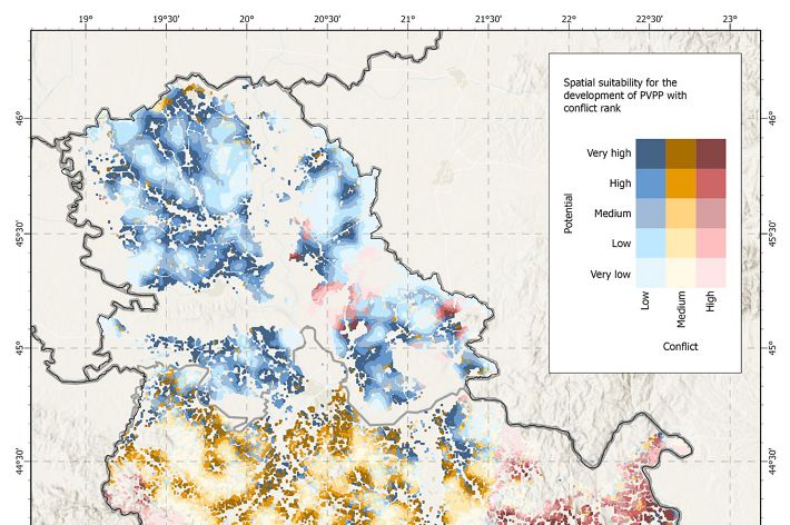
The resulting study is a map overlaying solar development potential with impact potential, as well as a selection of the 100 best sites for solar development according to both criteria, with an estimated installed capacity of 10 MW each. We estimate that 200,000—or 10%—of Serbian households could be powered from the 100 selected sites, saving one million tonnes per year in carbon emissions.
The map shows many blue areas in the north of the country indicating areas that have high solar development potential and low potential to impact the environment and communities. The middle of the country is largely yellow indicating medium potential for solar development there. The south of the country is red indicating low potential for solar development there.
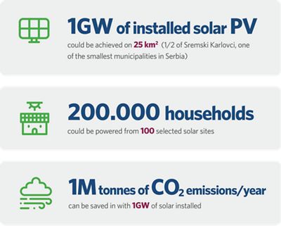
1GW of installed solar PV could be achieved on 25 square kilometers 200,000 households could be powered from the 100 selected solar sites 1M tonnes of carbon emissions/year can be saved with 1GW of solar installed
Our recommendations
We see potential applications for this study for a variety of stakeholders who are working to accelerate progress toward a net-zero economy in Serbia. Based on the findings, here are our recommendations for each group:
click below to expand
-
Based on this initial analysis, government leaders should recognize the value of establishing suitable low-conflict and high-energy yield zones for the accelerated development of renewable energy sources (Renewables Acceleration Areas). As a first step, governments should integrate spatial and renewable energy planning in their local development strategies and National Energy and Climate Plans (NECPs). Croatia, Slovenia, and North Macedonia have already taken this route, demanding the development of guidelines and criteria for the integration of a spatial component into renewables development planning. These countries are already implementing national-scale assessments of locations suitable for renewable energy, and other countries should follow suit—balancing energy needs with other elements of public interest, such as nature protection and food security.
-
The Secretariat should help coordinate the identification of Renewables Acceleration Areas in the Contracting Parties, anticipating the need that will come with EU Renewable Energy Directive transposition. Renewables Acceleration Areas should be part of the Contracting Parties’ strategies to tackle the permitting delays. The larger, regional scale of the Areas’ assessments could ultimately help the energy industry by creating the same rules for the Renewables Acceleration Areas across the continent and thus creating a more predictable regulatory environment for investments.
-
These institutions should enable technical assistance for European Union accession countries to identify Renewables Acceleration Areas and ensure frontload financing for projects developed in these Areas. This approach allows for significant initial investments, which is critical for rapidly establishing and scaling energy infrastructure.
-
Developers should use the maps and methodology for establishing low-conflict and high-energy potential Solar PV areas in order to avoid project delays and ensure a nature-and people-friendly approach. Developers should approach local communities and NGOs from the get-go, inviting them into an open dialogue and offering concrete cooperation opportunities. Success stories from other geographies indicate that the local communities are ready to cooperate and find win-win solutions when given the option to engage by participating in projects’ steering committees or via direct shareholding in projects.
-
We call on our peers and other experts to participate in the process of outlining Renewables Acceleration Areas and reach out to us if they are interested in applying our approach themselves or wish to provide critical feedback on our methodology.
Download
Learn more about our findings, methodology and recommended next steps for decision-makers in Serbia.
DOWNLOAD Download in SerbianGlobal Insights Newsletter
Sign up to receive our Global Insights newsletter and other select content for thought leaders who believe that, together, we can build a better future for people and the planet. We address the sustainability issues of the moment and explore potential solutions—all in a five-minute read or less.

