
From Constellation to Coral Reefs
Taking to the sky—even outer space—with revolutionary technologies to protect habitats beneath the sea.
Like other marine regions made up of low-lying islands, the Caribbean way of life extends beyond shorelines in a way that’s unique to people of the coast. But with more than 2.5 million square kilometers of sea connecting hundreds of diverse island communities, the region’s communion with the underwater world is perhaps particularly profound. In fact, about half those who work here have jobs that rely on healthy marine habitats, including a vital network of coral reefs.
These ecosystems are, of course, endangered, bearing the brunt of rising ocean temperatures—and Caribbean communities are tied up in their fate. According to a study led by The Nature Conservancy (TNC), reef-associated tourism alone generates an estimated US$7.9 billion per year for local economies. What’s more, coral reefs create habitat essential for the fishing sector and natural barriers that aid in coastal storm protection, to say nothing of the innate value of these ancient lifeforms.

More About the Maps
Fitting together thousands of images gathered via technologies in space, sky and sea, maps were created that reveal an unprecedented level of detail about underwater habitats.
View the maps and dive deeper into the technology used to create the maps.
Shedding light on the extraordinary value of coral reefs has helped catalyze innovative approaches to protecting them, but one problem has remained: many reef systems are uncharted, leaving nations struggling to protect and manage resources they can’t precisely see.
But not anymore. With the aid of aerial remote sensing technologies, TNC and partners have published the first-ever high-resolution maps of coral reefs and other marine habitats throughout the Caribbean basin. This means 30 countries and territories now have access to accurate information about the habitats on which they depend, helping to advance ocean conservation and prioritize climate adaptation for the 44 million people who call the region home.
Getting Technical: How to Make an Underwater Map
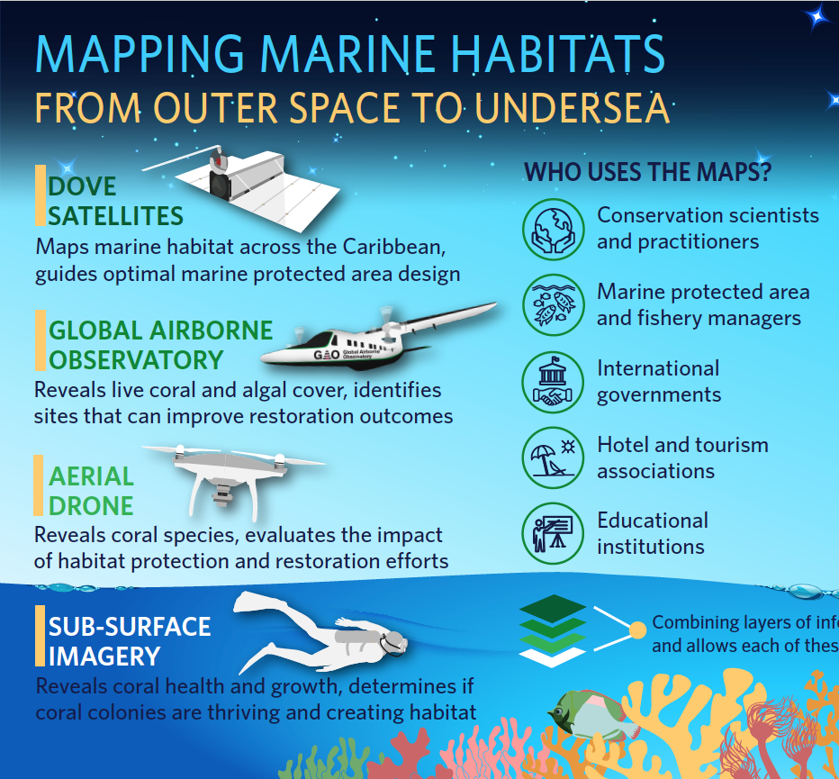
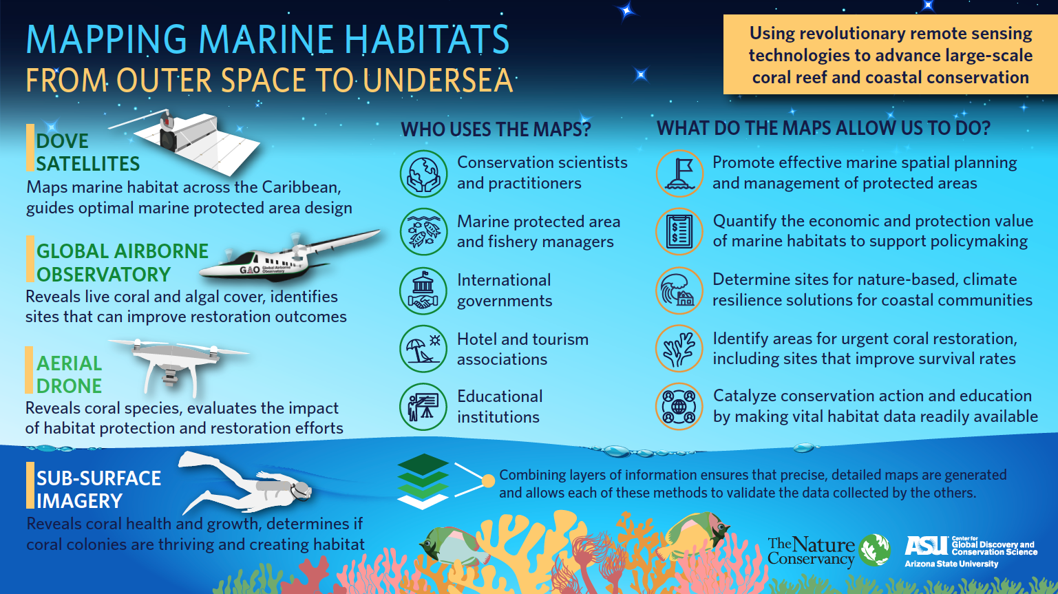
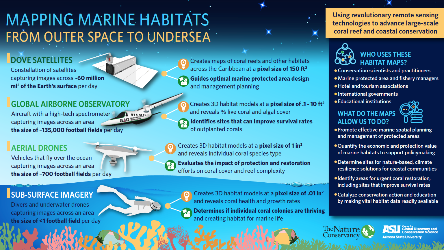
The process of creating these maps was a bit similar to completing a massive puzzle piece by piece. TNC scientists, working in partnership with Arizona State University’s Center for Global Discovery and Conservation Science, Planet Labs Inc. and Vulcan Inc., assembled more than 38,000 images captured by a “constellation” of Dove satellites that scans the Earth daily. In select geographies where active reef restoration is taking place, they collected additional imagery using the Global Airborne Observatory—a specialized aircraft equipped with a high-fidelity spectrometer that detects hundreds of wavelengths of light to reveal habitats in extremely fine detail. In an important final step, field data was collected using aerial drones and underwater cameras in order to validate the habitat maps created from the satellite and aircraft imagery.
Thanks to comprehensive data from outer space to undersea, the scientists were able to interpret each pixel of every image. From there, they developed three-dimensional models of nearshore and coastal habitats throughout the region—revealing the location and condition of coral reefs, seagrass beds and other oases of underwater life for the first time ever. Without the new technology, it would have taken divers millions of hours to produce similarly detailed habitat maps.
Download
-
 Infographics: Mapping Marine Habitats
From Outer Space to Undersea: Using revolutionary remote sensing technology to advance large-scale coral reef and coastal conservation
DOWNLOAD
Why Are These Maps So Important?
It is nearly impossible to protect resources effectively without knowing exactly where they are, their condition and the threats they face. But now, Caribbean countries and territories have access to a unique visualization of the habitats found beneath the waves surrounding their shores, which will help guide the sustainable use and protection of critical marine resources. The unprecedented detail of these maps allows conservation scientists and practitioners, fishery managers, governments, educators and other stakeholders to:
- Identify priority marine areas that need protection and guide sustainable use
- Quantify the economic and coastal protection value of marine habitats to support policymaking
- Measure climate change impacts and evaluate threats to design targeted, nature-based solutions
- Pinpoint sites in need of urgent coral restoration, including those where conditions are optimal for survival and growth of new corals
- Catalyze conservation action and education by making habitat data readily available
In the Caribbean, the fishing and tourism industries drive economic stability, and they cannot survive without healthy marine habitats. Yet, living coral cover in the region has declined by about 60 percent in the last three decades alone. Approximately 70 percent of people in the region live along its coastlines, but the nearshore habitats naturally designed to protect them from storm impacts are dying faster than science can restore them.
This breakthrough approach to habitat mapping is a key piece in unlocking solutions that can halt and reverse this alarming decline. By providing unprecedented layers of information on coral reefs and other habitats, we gain a new level of understanding that supports smarter conservation at the pace required for meaningful impact—not only for the Caribbean but for marine regions in other parts of the globe.
Scaling Up: The Future of a Breakthrough Approach
Already, the maps are helping island nations protect and restore their underwater habitats. The Dominican Republic became the first country to utilize this novel combination of remote sensing technologies to guide coral restoration, after scientists collected data on the chemical footprint and composition of habitats in the Arrecifes del Sureste Marine Sanctuary with the help of the Global Airborne Observatory.
Thanks to these comprehensive data, TNC and partners were able to identify optimal sites for reef restoration: areas where transplanted corals would be most likely to survive and where healthy habitats would most benefit surrounding ecosystems and coastal communities. In other words, a clearer picture of the sea floor surrounding this Caribbean country permitted scientists to pinpoint sites where restoration efforts would have the greatest positive impact for nature and people. Their insights guided one of the most significant reef restoration initiatives in the country’s history, in which dozens of volunteers from conservation organizations, government agencies and local businesses mobilized to the southeastern coast of the Dominican Republic and planted nearly 3,000 endangered staghorn coral colonies.
As the true value of coral reefs and other marine habitats becomes increasingly recognized, more sectors around the world are mobilizing to save them—not only fishing and tourism but also insurance, pharmaceutical, engineering and tech. And rightfully so: our scientific understanding of Earth’s complex underwater habitats is evolving rapidly, and only revealing more interconnectedness with people and communities.
The new habitat maps, and the technologies involved in producing them, can advance conservation further and faster by allowing us to make more informed and strategic decisions. In capturing a clearer picture of its undersea world, the Caribbean region will be able to chart a new path forward for the preservation of its greatest asset, the ocean, and become more resilient in the face of a changing climate. And as the testing ground of this revolutionary approach, the Caribbean region’s initiative is indeed likely to make waves far beyond its shores for the benefit of endangered habitats—and the people who rely upon them—around the globe.
Quote: Steve Schill, Ph.D.
These maps mean smarter conservation. They empower an entire region to better manage the complex threats facing its ocean. And the benefits will grow exponentially as the maps are used across islands with shared marine ecosystems.
Our Aerial Mapping Mission in Pictures


Join the Conversation
Share this page on Twitter | Share on Facebook
Follow @nature_org for updates from The Nature Conservancy.
Download Infographics
Using revolutionary remote sensing technologies to advance large-scale coral reef and coastal conservation
Related Reading

It's Not Too Late to Save Coral Reefs
Coral reefs are imperiled worldwide, but engaging new sectors in conservation could help us save these vital ecosystems.

How Science and Innovation Can Save Caribbean Coral Reefs
Explore how we're scaling up coral restoration and mobilizing world-class science to save imperiled reefs before it's too late.

Insuring Nature to Ensure a Resilient Future
Integrated solutions linking nature and insurance can help to reduce risk and build resilience to the impacts of climate change.
Global Insights
Check out our latest thinking and real-world solutions to some of the most complex challenges facing people and the planet today.