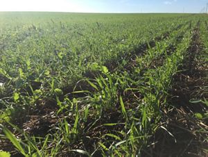
Places We Protect

Big Pine Creek

Working with agriculture to meet the growing demand for food while protecting our lands and waters

Shallow creek runs through rock formations in green forest.
Big Pine Creek Located in western Indiana © Fauna Creative

Quote: Seth Harden

Conservation takes time, and we’re in it for the long haul.

Upper Wabash River project director, TNC

Overview

Description

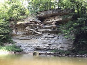
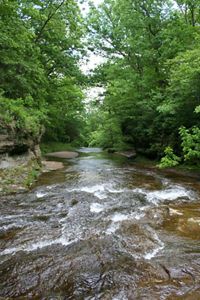
The Big Pine Creek Watershed is one of a kind. The 209,000-acre Watershed extends across four counties in west central Indiana. The northern and western regions of the Watershed were historically prairie, and the southern and eastern regions were woodland. The topography ranges from flat highlands in the headwaters to rolling and cavernous in the lower reaches. Big Pine Creek empties directly into the Wabash River upstream of Attica, Indiana. This diversity of land types and land uses presents unique challenges, but also great opportunity.

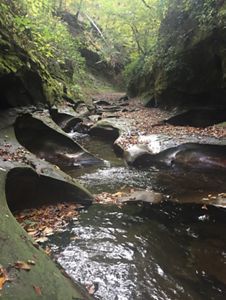
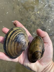
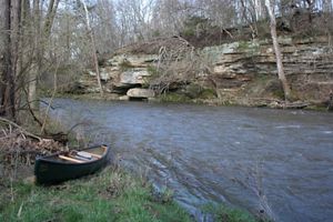
Big river fish regularly travel upstream from the Wabash River to calmer water and can often be spotted in the eddies and holes worn in the bedrock substrate by millennia of flowing water. Springs and clear water tributaries provide cool, fresh water to the system. The unique riparian features of Big Pine Creek support rare flora and fauna that can be found few other places in Indiana.

Access

Limited Access

This landscape is a mix of public lands and private working lands.

Size

209,000 acres

Explore our work in Indiana

Big Pine Creek

The Big Pine Creek is one of a kind. The 209,000 acre watershed extends across 4 counties in west central Indiana.

Big Pine Creek runs through wooded rocky terrain.
Man in blue kayak on calm creek.
Small brown catfish on outstretched hand.
Two freshwater mussels in outstretched hand.
Sandstone bluffs next to creek.

Opportunities in the Big Pine Creek Watershed

Most would see the interface of the freshwater conservation and agriculture as a space of turmoil and tradeoffs. Rather, partners and stakeholders in the Big Pine Creek Watershed have seized the complexity as an opportunity for understanding and efficiency to be discovered.

It is quite common to see business CEOs conversing with grassroots environmental advocates along the banks of Big Pine Creek due to the culture that has been built since TNC originally invested in the watershed in 2013.

Thus, the Big Pine Creek Watershed Project was created. TNC is partnering with the U.S. Department of Agriculture, local soil and water conservation districts, agricultural retailers, food companies and farmers on the project.

From day one, the Big Pine Creek Watershed Project was designed to be scaled and replicated. While unique in many ways from an ecological standpoint, the watershed is also representative of many other rural watersheds dominated by an agriculture land use. Agriculture is a major economic driver, supporting countless Indiana families, and also a point of pride for the Hoosier state.

The Watershed Project has been designed specifically to embrace current land use (rather than reject it), but to also promote resilience, sustainability, and efficiency in agriculture production. These concepts are universal and can be communicated anywhere in the Midwest. 

Big Pine Creek Watershed (10:45) 209,000 acres. Four Indiana counties. The Big Pine Creek Watershed Project is a unique project to assist with water quality on a massive scale.

The objective of the Big Pine Creek watershed project is irreversible change to attitudes and mindset. Over the last five years, TNC has played a major role in building key relationships, calibrating educational opportunities, and building a local network that will sustain regenerative and resilient agriculture systems across the landscape. These ongoing efforts will help us reach a tipping point where these systems are the norm, rather than the exception.

Recognition of the work and accomplishments of the Big Pine Creek Watershed Project has expanded beyond local influence to include domestic and international audiences. For example, watershed partners have hosted groups of conservation practitioners from most notably China and Brazil, but also from over a dozen states via its willingness to showcase collaboration in a unique way.

The Watershed management plan first completed in 2015 has been a core directive for the project, but has now been dwarfed by the accomplishments of the work. The planning efforts were supported by The Nature Conservancy and a private foundation in the amount of $125,000. In the last three years the total investment (in-kind and cash) for the watershed has surpassed $6,000,000.

Challenges in the Watershed

Project implementation has been optimized to environmental solutions for the dominant ag sector in the Watershed. This includes designing and testing solutions that improve environmental outcomes AND on-farm profitability. In-field Best Management Practices (Cover crops, nutrient management, conservation tillage) have naturally become the most effective in working with farmers and landowners in the Watershed.

Synergy in project narrative between conservation practice and economics allows a conversation entry point that is not commonly used by environmental organizations.

Two people hike alongside colorful moss-covered sandstone cliffs. One uses a kayak paddle to point to a spot on the cliff wall.
Exploring along Big Pine Creek Big Pine Watershed Coordinator Leslie Fisher and volunteer Hunt Wiley explore the fauna on the bluffs above “Foam Hole” a unique site on the mainstem of Big Pine Creek. © Brooke Sauter

Data collected via IDEM's Hoosier Riverwatch program by volunteers and partnership staff indicated:

  • Dissolved Oxygen Levels were maintained in the watershed based on collected data.
  • A downward trend in observed E. Coli colonies indicates improvement.
  • A downward trend in observed Nitrate levels indicates improvement.
  • A downward trend in water temperature may indicate improvement, assuming consistent climatic conditions.

Overall, IBI scores and total number of fish species collected trended upward for all sites over the three-year study period. Four sites with “Impaired Aquatic Communities” as defined by IDEM were identified in 2015. By 2018, data indicated that only one of the sampling sites carried that impairment designation.

Notably in 2018 at the end of the study period, one fish species previously on the Indiana “threatened“ list and still having a limited distribution in the state is the bluebreast darter. This fish was collected in both Mud Pine Creek and Big Pine Creek during the 2018 survey.

The Big Pine Creek RCPP played a key role in exceeding the nutrient reduction (40 tons of Phosphorous, 140 tons of Nitrogen) and sediment reduction (7,263 tons) goals set out in the Big Pine Creek Watershed Management Plan (WMP). An update to the WMP in 2019 extends new goals of nutrient reduction (additional 40 tons of Phosphorous and 140 tons of Nitrogen) and sediment reduction (additional 1,263 tons) to 2024. We expect similar trends of continuous improvement throughout the watershed to again meet those goals.
 

Working with Agriculture (00:56) TNC is working with farmers to implement voluntary, industry-led approaches to improve soil health. Improved soil health will help reduce the amount of nutrients entering waterways that lead to the Great Lakes and Mississippi River, thus improving water quality.

Partnerships

Forty-two project partners committed and delivered $1,497,62.64 worth of in-kind labor, expertise, and influence in the Watershed during the first three years of the project.

The Big Pine Creek Watershed Project’s strength lies in its diversity and number of stakeholders. 42 partners have made commitments to the success of the project. Project leaders have made great efforts to build a narrative around the purpose and necessity of action in the watershed. This effort has drawn the attention of governmental, academic, corporate (domestic and global), non-governmental organizations and private individuals. 

Big Pine Creek

This diversity of land types and land uses in the Watershed presents unique challenges, but also great opportunity.

Shallow creek riffles in wooded landscape.
A group of Nature Conservancy staff stand in shallow creek on sunny fall day.
Farm field growing small green plants.
Many people sit/stand on green grass under a blue sky at an event.
Kayak on bank of creek.

Project partners focus on concentrating conservation investment in the Watershed through strategic leveraging, ROI analysis, and objective-focused delivery. Furthermore, project partners actively track data and provide evidence for continued investment.

Public funding and project partners in the Watershed for the last three years catalyzed 26,000 acres of cover crops, 8,200 acres of conservation tillage, 135 acres of grassed waterways, 602 acres of conservation cover,  11 acres of critical area plantings, 97 acres of field borders, 53 acres of early successional habitat development, 49 acres of forage and biomass plantings, 48 acres of tree/shrub establishment, 25 HUAP installations, 2 stream crossings, 7 watering facilities and 4 waste storage facilities.

Major corporate conservation initiatives were formed with Land O Lakes, Coca-Cola and Tate & Lyle. Additional relationships were formed with Indiana-based and smaller companies, such as Ceres Solutions Cooperative, to improve corporate practice and demonstrate impact on land within watershed boundaries.

The Big Pine Creek RCPP has been a catalyst for additional and diversified conservation funding in the Big Pine Creek Watershed. To date, the $3.1 million RCPP has been key in leveraging an additional $2.9 million to voluntary on-farm conservation via supply chain initiatives, research projects, private grants and other governmental programs.

The Big Pine Creek Watershed Project RCPP has been extended through 2027 with additional investment of $2.3 million.

Find More Places We Protect

The Nature Conservancy owns nearly 1,500 preserves covering more than 2.5 million acres across all 50 states. These lands protect wildlife and natural systems, serve as living laboratories for innovative science and connect people to the natural world.

See the Complete Map