St. Marys River
A blackwater river that both divides and unifies Georgia and Florida, flowing from the Okefenokee Swamp to the Cumberland Sound.

The February air was cold and crisp. As I boarded the long, metal tour boat and claimed a front seat, I readied my camera and binoculars. On cue, a red-shouldered hawk cried from the top of a nearby pine. “Welcome to the St. Marys River,” she seemed to say. My fellow tour attendees followed suit in a quick retrieval of their binoculars and bird call identification apps. Another hawk appeared and the two raptors took flight as our tour began.
Here at the Traders Hill boat ramp, the St. Marys Riverkeeper has invited us to experience the beauty of the short blackwater river that divides Florida and Georgia. On this February day, bundled in our down jackets and blankets, the sun peeped behind the clouds to warm us and brighten the shimmering waters ahead.
Between the banks, whether tour attendees hailed from the Florida side or Georgia side of the river, we united to learn about the St. Marys' challenges and solutions.


An oak with yellow pollen hovers above the dark waters of the St. Marys River.
The Free-Flowing Blackwater River
The St. Marys River runs 130 miles from its starting point in the Okefenokee Swamp to the Cumberland Sound in the Atlantic Ocean. The basin—the surrounding area that drains into the river and its connecting creeks and streams—covers about 1,300 square miles in Georgia. Also called a watershed, the basin has more than 3,000 miles of streams and tributaries.
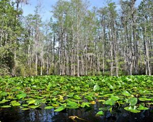
As seen from my seat on the river tour, its banks are lined with marshes, limestone outcroppings, sprawling tree roots and jutting cypress knees and forests made up of pine, oak, maple and palm trees. It also has large sandy banks, white as winter snow.
The St. Marys divides Florida and Georgia, but similar wildlife can be found along both states’ banks, including black bear, red-cockaded woodpeckers, gopher tortoise and bobcats.
Water’s Journey From Swamp to Sound
Protecting the St. Marys River starts at the river’s source: the Okefenokee Swamp. The Okefenokee Swamp is considered one of the most well-preserved freshwater areas in the country. Located in the southeast corner of Georgia, the Okefenokee Swamp spans around 700 square miles and is the largest blackwater swamp in North America.
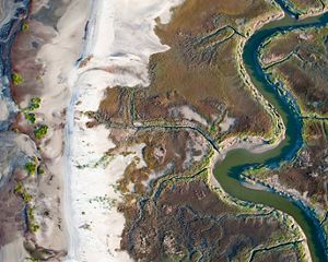
From the Okefenokee Swamp, tea-like tannic waters flow eastward towards the Atlantic Ocean. As the river reaches the coast, it widens, contributing to a rich estuary that is home to redfish, flounder, spotted sea trout, oysters, shrimp and other marine life. The St. Marys flows into Cumberland Sound and its barrier islands, most notably the large, nationally protected Cumberland Island.
The Cumberland Island National Seashore is one of the largest and most diverse barrier islands on the Atlantic Coast, serving as an essential refuge for nesting loggerhead sea turtles and shorebirds like American oystercatchers, piping plovers and least terns. The island is made up of salt marsh, mud flats and tidal creeks. Its undeveloped dunes and maritime forests provide habitat for many species, including gopher tortoises, alligators, and wild turkeys. The surrounding estuaries provide habitat for marine life like manatees.
Protected By Partners
Groups like The Nature Conservancy, the Conservation Fund and St. Marys Riverkeeper fought against a proposed titanium mine on the Okefenokee Swamp’s southeastern boundary.
Read More

Guardians of the River
The St. Marys Riverkeeper, led by Executive Director Emily Floore, works to keep the river clean and resilient. As the river forms the boundary between Georgia and Florida, they work with regulators and elected leaders in both states. They also host events like boat tours to share the beauty of the river, volunteer clean-ups and water quality trainings and citizen-scientist monitoring events to test the water’s health.
Quote: Emily Floore
It’s our river, and our responsibility to protect it.


Studying Sturgeon
St. Marys Riverkeeper partners with local, federal, state and non-profit partners to research federally endangered Atlantic and shortnose sturgeon in their southern-most river habitat. In 2014, University of Georgia researchers found a one-year-old sturgeon in the St. Marys. Its age indicated that it was born in the river, leading researchers to believe that sturgeon were spawning here. That finding spurred investigation, leading to extensive sonar scans and lateral bank-to-bank surveys of the river bottom.
Researchers do not yet know exactly when or where sturgeon spawn in the St. Marys, but continued data collection could help expand protection for these ancient fish and create a model for similar studies in other rivers.
For short-nosed and Atlantic sturgeon, a spawning ground’s potential depends on the rivers’ bottom. Their ideal spawning areas are hard bottom, such as limestone, that provide crevices or holes to protect their eggs from fast-flowing water. Sturgeons also need certain water quality parameters for their eggs and larvae to survive.
With funding from The Nature Conservancy, St. Marys Riverkeeper is working to tell the story of this sturgeon study with a documentary.
Water Quality in the St. Marys River
The St. Marys River, situated in a relatively rural and remote part of Florida and Georgia, has historically experienced limited development and pollution discharge points. But while the river’s water quality is generally stable, it is especially sensitive to nutrient overloads, sediments like excess soil washing into the river and chemical contaminants from nearby pollution sources. Urban growth in the surrounding areas often comes with an uptick in stormwater runoff, illegal dumping and general trash pollution. Pollutants like plastic bags, motor oil, fertilizers and sewage enter the river through drainage ditches and creeks.
According to the Riverkeeper’s recent Water Quality Monitoring Program data, they’ve seen alarming spikes in bacteria levels in key tributaries after heavy rains. This year, Riverkeeper volunteers have removed over five tons of trash and debris from the river and its banks.
Other Threats to the River
The river and the communities that surround it are also threatened by the impacts of climate change, including tidal changes, storm surge following hurricanes, shoreline and riverbank erosion and other threats.
The Nature Conservancy has contributed to a multi-partner, regional effort to help make St. Marys River communities more resilient. Together, with local leaders and technical experts, we’re helping to develop a Watershed Resiliency Plan that addresses both current threats and long-term climate resilience.
By protecting our river and its tributaries, we deploy nature-based solutions that work.
We Can’t Save Nature Without You
Sign up to receive monthly conservation news and updates from Georgia.

Shared Border, Shared Responsibility
The St. Marys river, from swamp to sound, is worth protecting. And not just because it’s beautiful and supports local tourism and recreation-based economies – but because it plays a role in larger conservation conversations.
As the boat tour travels under the old Tropicana bridge and passes the historic riverside cabin that was once a popular place to stop and buy bait, I envision a snippet of past life here. Waving to a neighbor as your boats pass in the early morning light. Watching the slow patrol of fishing herons along the river banks. Unpacking sweet tea and sandwiches on a sandy shore. Climbing up a tall cypress tree and swinging off a rope tied from a low branch. Stopping in the store for a soda, a honey bun and a weather report from the clerk before the boat ride home.
In this vision, it doesn’t matter which bank you live on or what Florida or Georgia town you call home. It’s one St. Marys river community.
Today’s tour reminded me of the intertwined nature of our states. While I’ve lived in north Florida all my life, my kin hail from middle Georgia. I spent summer exploring the north Georgia mountains, fall family reunions near Macon and camping trips along the coast. And while the inter-state energy does get hostile for football games, we are one family. Even before European settlers gave Florida and Georgia their boundaries, people have lived along and across these arbitrary lines for thousands of years.
We share more than we realize. This river and the water and wildlife it contains are our shared responsibility. It’s a gift we can enjoy together, and a place we can protect forever.
The river represents the bridging of a divide and a not-so-new, cross-state way of protecting lands and waters. Partnerships such as those between the Nature Conservancy and the St. Marys Riverkeeper exemplify what is needed to continue protecting our shared natural resources: community connections and collaboration.
Story written by Carson Mitchell Peña, a staff writer based in Tallahassee, Florida.


