


Lower Green River in Kentucky The lower Green River near Henderson, Kentucky is an important tributary to the Ohio River, which ultimately joins the Mississippi River. © Fauna Creative
Mike Morton grew up hunting waterfowl in the area now established as the Green River National Wildlife Refuge. For over 30 years, he advocated for improving this section of the lower Green River floodplain.
“It’s been a very long and personal history for me, trying to get this established on the ground because I think it’s an important place,” Morton said. “I spent my career as a wildlife management area supervisor, and much of that work focused on shallow-water waterfowl habitat. It’s been both a personal and professional focus my entire life.”
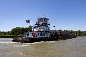
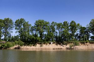
As the secretary of the Friends of the Green River Wildlife Refuge, Morton continues to support the development of the refuge, which was established with 10 acres in November 2019, and has grown to nearly 2,000 acres. Working for the Kentucky Department of Fish and Wildlife, Morton flew aerial waterfowl surveys in the area and has seen the river change significantly. Levees were installed to protect farmland from flooding and dams were added to support the ever-growing barge traffic. Those dams raise the river level, continually swamping and eroding the riverbank. And this part of the river is surrounded by field after field of row crop agriculture.
It’s been a very long and personal history for me, trying to get this established on the ground because I think it’s an important place.
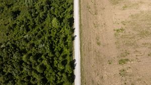
Morton is standing in what looks like a prairie, but closer inspection reveals a newly planted bottomland hardwood forest, an effort by refuge staff to restore the floodplain—broadly cleared for agriculture in the 1800s—to its more natural state. On this late spring day, migrating birds including bright indigo buntings and melodious warblers, fly overhead between the treetops. Beyond the mature tree line, the lower Green River sparkles in the sunlight. As this forest matures, it will create a corridor for native wildlife, including turkey, deer and woodcock, and give the river space to overflow.
“We are working with The Nature Conservancy (TNC) and other partners on a long-term plan for this area,” said Kimberly Sykes, acting refuge manager of the Clarks River and Green River national wildlife refuges. “We could potentially open it to the public, adding some viewing areas and hiking trails. With planned water control we could hold the right amount of water on the floodplain a little longer to make it available during the migration period for both waterfowl and shorebirds,” Sykes said.

Repeating What Works
TNC has worked across the Ohio River to restore the lower Wabash River in Indiana and Illinois for decades. Conservationists see an opportunity to bring that experience to the lower Green.
“We’ve had incredible success on the Wabash with wetland restoration, conservation and floodplain habitat work. Building on that success, TNC is looking at a more holistic, whole-river approach and focusing on the health of the Ohio River, including the Wabash and Green rivers,” said Tyler Sanderson, floodplain conservation manager at TNC in Kentucky.
That success is rooted in community connections. By starting with public listening sessions, the teams working on the lower Wabash were able to match restoration projects to community needs. Those listening sessions inform decisions about where to focus the restoration and how to accomplish the work. Next, teams study scientific maps of the area to identify where restoration work will yield the most benefit, considering flood history, water quality and habitat. All the quantitative and qualitative data are then pulled together into an ecosystem enhancement plan.


The Green River and the Wabash River are both major contributors to the Ohio River, and much of the floodplains actually come up through its tributaries. All of these pieces are part of a larger system, so the health of the lower Ohio River depends on the health of its major tributary rivers. This interconnected nature of rivers illustrates the need for holistic planning.
“We believe we can take that knowledge, understanding and experience that the community has developed in the Wabash watershed and build that same thing here,” Sanderson said about the lower Green River. “The first step is to understand the community and what the community needs, what their desires are with their river and their floodplain, and understanding how TNC can help serve those needs.”
Fishing the Green River, the kind of a hidden gem is that it’s super productive. The amount of fish and the size of the fish and the variety of species—it just blows my mind.
Making Connections and Building Partnerships
An important partner in the lower Green is the Natural Resources Conservation Service (NRCS).
“Being able to assist farmers is one of my goals. I always wanted to farm, so this is the next best thing,” said Justin Mooney, supervisory district conservationist for the Ohio Valley Work Unit. Mooney grew up in the area and is raising his own family there. “When we’re working with private landowners, especially farmers, they have to make a living. So we have to figure out conservation projects and practices that allow them to continue making that living while still creating environmental benefits.”
And connecting natural wetlands, restoring natural flows, benefits the broader community by giving flood waters somewhere to go.
“What might just look like woods to some people is actually providing wildlife habitat and ecological benefits. When you connect those systems, it makes a real difference,” Mooney added.
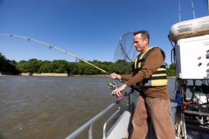
Building connections in the community not only informs the work, it reminds everyone why it is so important to get it right. Christopher Bauer, a Friends of the Green River National Wildlife Refuge board member, enjoys fishing the lower Green River several days a week.
“The Green River is a hidden gem for fishing. The amount and size of the fish and the variety of species in the river—it just blows my mind. I feel like establishing the wildlife refuge is that monumental first step to overall improvement of the health of the river. It’s an exciting time,” Bauer said.
The amount of information that we got back from the community and their passion for the river was really eye-opening to me.
Restoration Potential
The lower Green River is an important natural resource for Kentucky and an incredibly diverse ecosystem. As the community and partners plan restoration of the floodplains and identify opportunities for improved land use, the potential to enrich the community’s experience with the river and contribute to a healthier river system is remarkable.
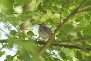
Songbird near the Green River: The lower Green River is an important rest stop for migratory birds, delighting local birdwatchers. © Fauna Creative
Barge on the Green River: A barge travels the lower Green River near Henderson, Kentucky. The Green is an important tributary to the Ohio River and part of the Mississippi River Basin. © Fauna Creative
Land use contrast: This aerial photo shows a stark contrast between lush, green restored land on the left compared with farmed and tilled land across the road. © Fauna Creative
Lower Green River in Kentucky: The banks of the lower Green River in Kentucky show clear signs of erosion. TNC is working to restore habitat and floodplains in the lower river. © Fauna Creative
Fishing the lower Green River: Chris Bauer casts a line in the lower Green River. Chris is a board member of the Friends of the Green River National Wildlife Refuge and fishes the river every week. © Fauna Creative
Meeting Bauer and other members of the community and learning about their connections with the river is shaping the project. Building trusted relationships with the local community and partners including state and federal agencies, local nonprofits and other groups helps the team layer together opportunities and build bigger solutions.
“The community listening sessions and our partners meeting brought me hope for this project,” Sanderson said. “The amount of information that we got back from the community and their passion for this river was really eye-opening to me.”
For Morton, 30 years of work is finally paying off. “It’s not for me, and it’s not for my generation. It’s for my brother’s sons’ and daughters’ generations,” he said.
For TNC, the opportunity reaches beyond a single project. Conservation teams are mapping the entire lower Ohio River, from the confluence with the Green, the Wabash and the Cache River in Illinois, all the way to the Mississippi to improve the health of the Ohio and, ultimately, the Mississippi River.
We Can’t Save Nature Without You

More freshwater stories

Wabash River
For more than four decades, The Nature Conservancy has worked to conserve and protect the Wabash River and its surrounding lands.

Protect Lands and Waters
The Nature Conservancy in Illinois is working to protect the lands and waters on which all life depends.

What is a floodplain?
(2:36) Watch this video to learn how healthy floodplains provide habitat and clean water in river systems.