Trail Descriptions
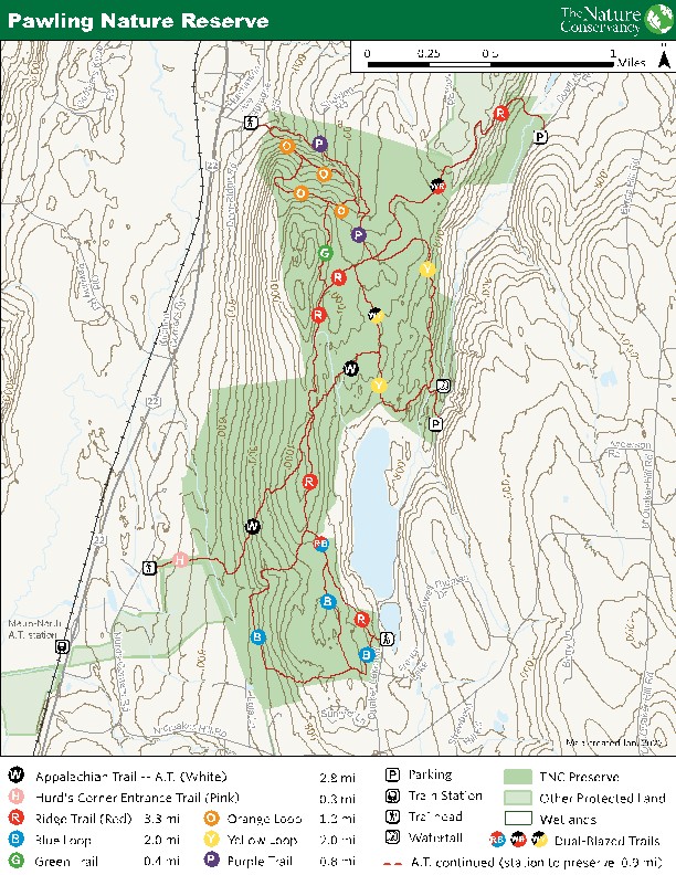
Plan ahead and prepare for your hike at Pawling Nature Reserve. There are eight trails to choose from. Together, they total about 12 miles. Please note that all mileages listed are one-way distances. Here’s what to expect when you hit the trails:
Yellow Loop: The Yellow Loop is a moderate hike and is marked with yellow paint blazes. The trail is two miles long and can be accessed via the main trailhead on Quaker Lake Road. It is a natural soil surface trail that passes through forested uplands, with views of the Duell Hollow Brook gorge and waterfall. Enjoy some educational signage along the trail, including a tree species guessing game. Expect 500 feet of elevation gain and a typical trail width of 89 inches; at its narrowest, the trail is 10 inches wide. The typical grade (incline) is 11%, with a maximum grade of 40% and a typical cross slope (the incline across the trail) of 7.5%. Expect small natural stream crossings and some obstructions, such as rocks, roots and fallen trees.
Appalachian Trail (White): The AT is a National Scenic Trail that runs all the way from Georgia to Maine. The portion of the AT that passes through PNR is a moderate-to-difficult hike that is 2.8 miles long, marked with white rectangular blazes. The AT can be accessed via the Pink Trail, the Yellow Trail, or the Red Trail within the preserve. It is a natural soil surface trail that passes through forested uplands including a ridgetop chestnut oak-mountain laurel forest. If you follow the trail north, you’ll be climbing up Hammersley Ridge. Expect 830 feet of elevation gain and a typical trail width of 28 inches; at its narrowest, the trail is 10 inches wide. The typical grade (incline) is 9.2%, with a maximum grade of 52% and a typical cross slope (the incline across the trail) of 6.1%. Expect small natural stream crossings, some areas of more dense plant growth, some light rock scrambling and natural obstructions such as rocks, roots and fallen trees. Some areas of the AT are more prone to flooding, so expect wet, muddy conditions on and after rainy days.
Pink Trail: The Pink Trail is a moderate hike that is marked with pink blazes. The trail is 0.3 miles long and serves as an entry point to link up with the AT. It can be accessed via the trailhead on Hurds Corners Rd. Expect about 150 feet of elevation gain. Expect some areas of more dense plant growth and some natural obstructions such as rocks, roots and fallen trees.
Blue Loop: The Blue Loop is a moderate-to-difficult hike that is marked with blue blazes. The trail is two miles long and can be accessed via the French Lake trailhead on Quaker Lake Rd. It is a natural soil surface trail that passes through forested uplands. Expect 725 feet of elevation gain and a typical trail width of 18 inches; at its narrowest, the trail is 4 inches wide. The typical grade is 10%, with a maximum grade of 58.7% and a typical cross slope (the incline across the trail) of 7.8%. Expect some areas of more dense plant growth and some natural obstructions, such as rocks, roots and fallen trees. The Blue Loop has a long series of wooden bog bridges, and is more prone to flooding, so expect wet, muddy conditions on and after rainy days.
Ridge Trail (Red): The Ridge Trail is a moderate-to-difficult hike that is marked with red blazes. The trail is 3.3 miles long and can be accessed via the Duell Hollow Rd trailhead or the French Lake trailhead on Quaker Lake Rd. It is a natural soil surface trail that passes through forested uplands, including a ridgetop chestnut oak-mountain laurel forest, and a small swamp. Expect 945 feet of elevation gain and a typical trail width of 28 inches; at its narrowest, the trail is 4 inches wide. The typical grade is 10%, with a maximum grade of 48.6% and a typical cross slope (the incline across the trail) of 5.4%. Expect small stream crossings and some natural obstructions, such as rocks, roots and fallen trees.
Orange Trail: The Orange Trail is a moderate-to-difficult hike and is marked with orange paint blazes. The trail is 1.7 miles long and can be accessed via the Furlong Rd trailhead. It is a natural soil surface trail that passes through a cool ravine and forested uplands. Expect 630 feet of elevation gain and a typical trail width of 24 inches; at its narrowest, the trail is 10 inches wide. The typical grade (incline) is 14.4%, with a maximum grade of 53% and a typical cross slope (the incline across the trail) of 9.5%. Expect natural stream crossings and some obstructions, such as rocks, roots and fallen trees. **Please note that this trail is not yet fully marked and has experienced high levels of fallen trees, so it may be confusing in some areas.**
Green Trail: The Green Trail is an easy-to-moderate hike and is marked with green paint blazes. The trail is 0.4 miles long and acts as a connector trail between the orange and red trails. It is a natural soil surface trail. Expect natural stream crossings and some obstructions, such as rocks, roots and fallen trees. **Please note that this trail is not yet fully marked, so it may be confusing in some areas.**
Purple Trail: The Purple Trail is currently under construction. The trail is not fully marked and is impassable in some areas due to fallen trees. The Purple Trail is 0.8 miles long. There are some sections that are very steep and slippery around the creek. Proceed with caution!