- Phone: 501-663-6699
-
Follow


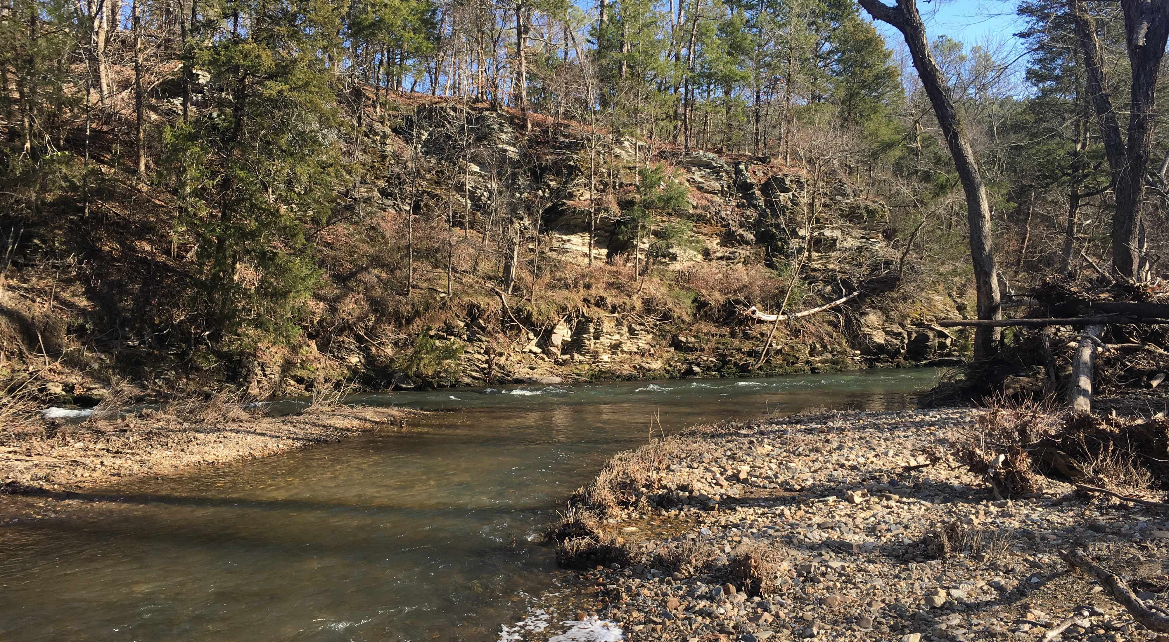
Flowing mostly through forests, the Saline River’s forks are among the state’s healthiest streams.
There are no public fishing lodges. No marinas. No campgrounds. And no notoriety. The upper Saline River watershed, which includes four major tributaries—the South, Middle, Alum and North forks—is one of the most overlooked watersheds in Arkansas. Talk to folks who have fished it, though, and they’ll tell you it’s one of the Natural State’s best-kept secrets for rock and smallmouth bass fishing.
While there aren’t many services, there are several access points along each of the forks, which flow from the foothills of the Ouachita Mountains between Hot Springs and Little Rock. Take a look at a map of the watershed, and aside from Hot Springs Village, you’ll see only a few small towns —Jessieville, Crows, Owensville and Paron—before the four streams join together just south of Benton.
Because the Saline’s forks flow mostly through forests, they are among the state’s healthiest streams. In fact, the Alum, Middle and North forks have been designated by the State of Arkansas as Extraordinary Resource Waterbodies, or ERWs, which means laws are in place to provide extra protection from potentially detrimental actions such as damming and gravel mining. According to the state, ERWs warrant the extra protection because of their “scenic beauty, aesthetics, scientific values, broad scope recreation potential and intangible social values.” Of 20,000 stream miles in the state, only 1,500 miles have this designation.
The Saline River flows southeast from Benton before joining the Ouachita River at Felsenthal National Wildlife Refuge near the Louisiana border. It is the last major stream in the Ouachita Mountains that has not been dammed. While most Arkansans may not think of the Saline as an equal to the Buffalo, Mulberry or Cossatot rivers, those who work in water quality issues do.
A Biological Gem
“The Saline is one of the most pristine watersheds in Arkansas,” said Chris Davidson, endangered species coordinator for the U.S. Fish and Wildlife Service. “It’s rich in fish and mussel species.”
But the upper Saline watershed is under increasing pressures that range from illegal gravel mining, incompatible development and the damming of tributaries to stream bank erosion and increased sedimentation. Water quality has become too poor in the South Fork to support the Arkansas fatmucket mussel, a good indicator species for the overall health of these streams.
Davidson has spent countless hours on the upper Saline and its forks looking for Arkansas fatmucket mussels, a species his agency has listed as threatened. The Arkansas fatmucket lives only in the upper Saline River watershed and three other streams in the Ouachita Mountains.
Fortunately, not all the Saline’s forks are as bad off as the South Fork.
“The water clarity and habitat quality in the main stem and Alum Fork are big reasons why the Arkansas fatmucket has survived there while it is has disappeared or is declining in other parts of its range,” Davidson said. “The conditions that are important to largemouth, spotted and smallmouth bass are important to the Arkansas fatmucket.”
Davidson said the Arkansas fatmucket is also found in the Middle and North forks, but their numbers there are declining.
Saving the Saline
In an effort to maintain overall water quality in the upper Saline watershed and prevent further degradation, the Arkansas Natural Resources Commission in 2005 tasked The Nature Conservancy with analyzing land-use practices, describing the biggest threats to the river, and suggesting appropriate restoration activities.
The two-year study, funded by the U.S. Environmental Protection Agency’s Clean Water Act, concluded that among the river’s pollutants, sediment is one of the worst. The ANRC then asked the Conservancy to prioritize sediment sources in the Middle Fork.
“The initial study provided us the big picture of the Saline River’s status,” said Ouachita Rivers Project Manager Joy Wasson. “To begin addressing the issue of sedimentation, we started on a small scale at the Middle Fork.”
Wasson and her team of staff and volunteers analyzed and mapped land-use patterns throughout the Middle Fork watershed. They then looked at sediment sources—eroding stream banks, unpaved roads, development, timber management and pasture lands—and quantified their impact on the Middle Fork.
“The study helped us prioritize where and what the problems are,” Wasson said. “That enabled us to develop strategies to restore areas that are rapidly eroding.”
With funding from the U.S. Fish and Wildlife Service, the Conservancy in 2009 and 2010 partnered with the Arkansas Game and Fish Commission to restore a 2,600-foot bank section along the Middle Fork near Crows.
“This bank was collapsing and dumping about 1,770 tons of sediment into the Middle Fork every year,” Wasson said. “That’s equivalent to about 140 full loads from a dump truck.”
To keep the soil out of the river, the team changed the slope of the bank, constructed in-stream structures to focus the river’s energy toward the center of the channel, and planted trees and other vegetation to hold the earth in place. They erected fencing and created ponds for nearby landowners to keep cattle from getting into the stream and trampling the restored banks.
“Maintaining and improving water quality here helps threatened species as well as game fish, and it ensures a clean source of water for communities like Hot Springs Village and Benton,” said Wasson.
Preserve will help maintain the Saline River’s health
In December 2007, Cooper Communities of Rogers, Ark., donated 123 acres in Hot Springs Village along the Middle Fork to The Nature Conservancy. The forested property borders more than two miles of the stream and is less than a mile from the Middle Fork Barrens Natural Area, owned and managed by the Arkansas Natural Heritage Commission.
“Forested riverbanks like this are extremely important to the health of rivers,” said Wasson. “This new preserve will go a long way towards helping us achieve our goals of improving water quality in the upper Saline River watershed.”
Looking Ahead
“We’re also assessing sediment in the Caddo River and upper Ouachita River watersheds,” Wasson said. “We’ve received grant money to identify potential restoration sites, and we’re hoping to team with local landowners on these projects.”
Wasson and team are working with cattle ranchers in several Ouachita Mountain watersheds on compatible grazing techniques that limit areas where cattle access streams, a move that will keep critical stream bank vegetation intact. Wasson is helping the ranchers obtain funding for fencing and alternative water sources.
“We’re just taking each step one at a time,” Wasson said. “Ten years from now, I think we’ll be able to look back and see that, combined, these steps accomplished our mission of keeping the Saline and other Ouachita Mountain rivers clean and healthy.”