The Allure of the Altamaha
While Georgia’s Altamaha River often goes unnoticed, its waters exert a mighty pull on the state and on the lives of a passionate few.
Autumn 2012
Just south of Savannah, Georgia, on I-95, the major north-south highway that hugs the East Coast, a bridge crosses the Altamaha River. In the blur of 65 miles an hour, it’s easy to miss the water.
And many people have. But if they slowed down, and if they looked down, they would see a wide, dark river, its banks covered in a tangle of mixed hardwoods, pines and palmetto all draped in the gray-green gauze of Spanish moss. They would see a river suspended in time and place.
The Altamaha has been called the river nobody knows—not even Georgians. This, notwithstanding the fact that it runs 137 miles across the state and is one of the largest undammed rivers east of the Mississippi. It drains more than a quarter of the state, pouring 100,000 gallons of water into the ocean every second. Its huge basin supplies millions of gallons of drinking water each day to Atlanta and other urban centers.
Despite the Altamaha’s near anonymity, there is a cadre of people who care passionately about the river. People like Jane Hurt Yarn, who, rather than risk losing a piece of the river to developers, spent tens of thousands of dollars of her own money to help protect it. And James Holland, a crabber who has devoted much of his life to documenting the Altamaha’s natural beauty and anything that threatens it. And there’s also The Nature Conservancy’s Christi Lambert, who has played the role of steadfast caregiver.
For 20-some years, Lambert has worked hand-in-hand with local landowners, river advocates, state officials, and military and industry representatives to help protect more than 100,000 acres within the Altamaha’s basin. Last year, the Conservancy’s purchase of a 1,080-acre parcel known as the Walker Lake Fishing Club laid into place the final piece of the puzzle on the lower Altamaha. That piece completed a corridor of protected land that runs an unbroken 42 miles along the banks of the river—starting near the town of Ludowici and ending at the Atlantic. In theory, a person could now travel the length of the Lower Altamaha, each step falling on protected ground.
That’s important because to understand the devotion the Altamaha generates—the kind of spiritual pull it has on people, the way it’s gotten under their skin—you’ve got to get close to the river. You have to stop, venture down the banks and dip your toes in the water.

Getting on the River
The best way to see the Altamaha is from the water. In a boat, you experience the pull of the tide and the rush of fresh water. You can glide under a cypress branch or fallen tupelo, or you can just sit silently, watching marbled godwits dance along thin strips of sand in the sun, the Atlantic wide open at their backs.
The strips of sand, deposited there by the river’s flow, are part of the ribbon of islands in the Altamaha Sound, where the mouth of the river opens to the sea. These islands protect the Georgia coast and the people and wildlife that live there. They are also part of a highly productive salt marsh environment that revolves around the movement of the tides and the interplay between plants and animals. This area, says Christi Lambert, functions as a biological “nursery,” cultivating life from the tiniest microbe to shrimp and fish, including the Atlantic sturgeon and its endangered cousin, the shortnose sturgeon.
The islands of the Altamaha, like the banks of the river itself, might have become endangered and developed. Some of their neighbors—nearby St. Simons Island and Sea Island—were long ago worked over into tourist spots, covered with golf courses and condominiums.
But an Atlanta woman who loved the coast had other ideas. Jane Yarn in 1969 persuaded her husband to buy one of the little barrier islands, Egg, to preserve it. Just two years earlier, Yarn had become passionate about protecting the environment while on a family trip to Kenya and South Africa. There, she found herself immersed in the environment and a witness to its destruction.
The experience changed her, says her youngest son, Doug. “She felt like she couldn’t do much for Africa,” he recalls of his late mother. “But she could do something for Georgia."

The Yarns bought Egg Island—all 593 acres—for $25,000. Jane Yarn continued her quest to protect Georgia’s barrier islands, working with the Conservancy to raise money to acquire Wolf and Little Egg Islands as well. She soon made a reputation for herself as the “marsh lady” and went on to play an even bigger role in the Conservancy and in state and national environmental issues. (She served as head of the White House Council on Environmental Quality under Jimmy Carter [see “The Way to Think About Rivers,” below].)
The island purchases launched the Conservancy’s efforts to protect miles and miles of the Altamaha.
Egg, Little Egg and Wolf Islands—5,126 acres in all— now form the Wolf Island National Wildlife Refuge. The islands are starkly beautiful, made up primarily of saltwater marsh with strips of sand and vegetation. Gentle waves lap at the white beaches, which are unmarred by docks. Tall, lush cordgrass, radiating green and gold hues, spreads out into the estuary, filling the watery fields where antebellum rice plantations once prospered.
Now it’s the birds that prosper. All day, oystercatchers, long-billed curlews, American avocet, and brown and white pelicans take to the air, then return in a game of tag- team fishing in the estuary. A sandbar nearby is the nesting spot of choice for 2,000 pairs of migrating brown pelicans.

Ancient Island
Traveling about 11 miles upriver along the protected corridor, you leave the Wolf Island wildlife refuge and the estuary behind. Now you are in the Altamaha Wildlife Management Area, where bald eagles nest and fill the sky. It’s not uncommon to spot as many as 10 in an hour—an eagle convocation.
Here, the cordgrass of saltwater tidal marshlands gives way to its freshwater counterpart, cut-grass. True to its name, this tall perennial can slice just about anything, including a dog’s nose. Plants like pickerelweed, a favorite of the endangered West Indian manatee, grow nearby.
The banks along the Altamaha’s freshwater tidal forests bloom purple with wild irises, while sabal palm fans and leafy viburnum roll across the landscape. Towering cypress and smaller Ogeechee lime and tupelo trees dip their elegant limbs toward the river.
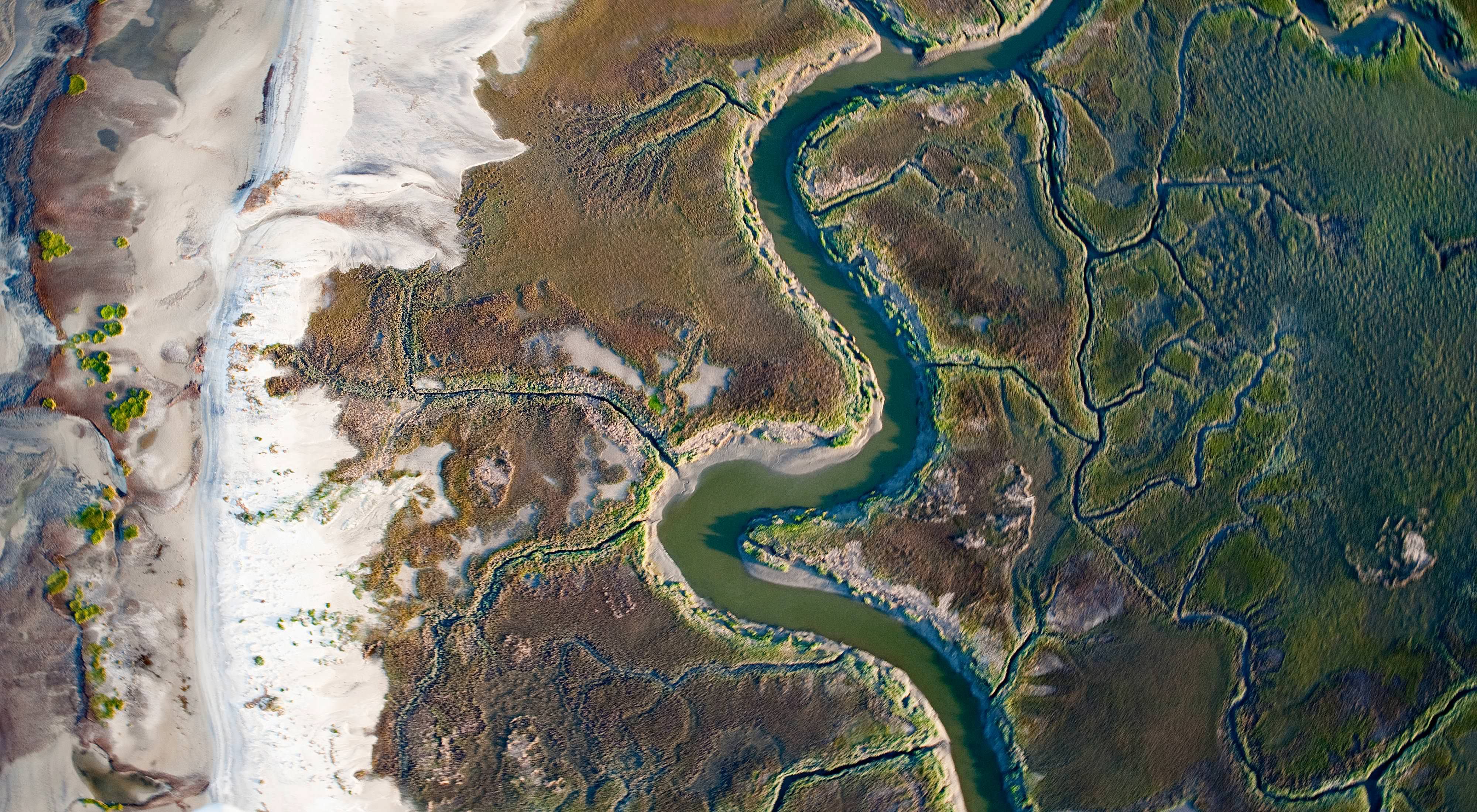
Everything adjusts to the changing tide as the river’s seaward motion halts and the river swells. Water climbs the banks; then in a few hours the tide recedes, leaving a mark like the ring in a bathtub. Mud and sandbars appear where water just flowed, and alligators lumber onto the flats.

Over thousands of years, the river’s sluggish current has carved out a meandering channel that nearly loops back on itself in several places. At times the river has tied itself in knots, forming oxbow lakes and even islands. That’s how 5,633 acres of bottomland, hardwood tidal forests and sandy ridges became Lewis Island.
From the river, the island appears welcoming, with rich forests and a springtime palette of pink native azaleas—sometimes called swamp honeysuckle for their delicate blooms and sweet smell. But the picturesque channels leading into the island require a thorough knowledge of the changing tides and hidden dangers of sandbars and submerged trees.
The island harbors a legendary forest. Although some of the island’s trees were harvested by timber companies, a 300-acre stand of old-growth cypress was spared. The ancient trees—some estimated to be more than 1,300 years old and 7 feet in diameter—are said to be among the oldest this side of the Mississippi. Story has it that the trees were too deep into the island’s swampy interior for loggers to reach. Timber equipment sank or got stuck. Some remnants still can be found today, rusting amid the cypress giants.
The value of these forests did not go unnoticed. In 1972, Jimmy Carter, then the governor of Georgia, made sure they would never face a sawmill. He created the Georgia Heritage Trust in collaboration with his friend and future White House environmental counselor, Jane Yarn. One of the first acts of the trust, which aimed to protect unique parcels of land in Georgia, was to purchase and protect Lewis Island (see “The Way to Think About Rivers,” below).

Held in Awe
A few miles up from Lewis Island, the river’s leafy banks conceal a system of narrow channels and lakes flanked by forests. James Holland will never forget the first time he came upon one particular lake, shrouded with a canopy of Ogeechee lime, sweetgum and cypress trees.
This bottomland forest had been felled by loggers more than a century ago. But the imperfect trees they left behind—some marred by disease or marked by lightning—were old, possibly as old as those on Lewis Island. For Holland, though, nothing compared to the lake’s cypress trees and their “knees”—mysterious roots that emerge from the dark water like ancient stalagmites. Some had grown 8 feet tall and were in clusters too wide for Holland to wrap his arms around. The experience, he says, was “like seeing a cathedral,” and the moment felt spiritual.
“When I saw those giant trees and cypress knees,” says Holland, “I knew from then on that I was home.”
Holland, now retired, had been a commercial crabber in the region since the 1970s. But after years of watching his blue crab harvests decline, he banded together with other crabbers in 1999 to start Altamaha Riverkeeper. The river advocacy group works to clean up the Altamaha Sound by pushing for pollution controls on industrial agricultural and timber operations upstream.
After discovering his swampy cathedral along the river, Holland added conservation to the Riverkeeper agenda. He began working with Lambert and the Conservancy to protect these forests, which were already on the Conservancy’s wish list.

In 2010 the work paid off when the Conservancy completed the purchase of 14,000 acres, including Holland’s cathedral. The Conservancy raised $25 million in private and public funding to cover the costs and then transferred the property to the state’s Department of Natural Resources—the Conservancy’s steadfast partner in the river’s protection and management.
The sandy ridges along this tract once supported massive longleaf pine forests, which ranged from Virginia to Texas. But most longleaf forests were cleared for timber by the early 1900s, and as the trees went, so went gopher tortoises, indigo snakes and red-cockaded woodpeckers.
Now Georgia’s natural resources department is restoring the longleaf forests in the Townsend tract, and coaxing the land back to its former glory.
And all that land is now part of the Townsend Wildlife Management Area, which is open for birding, hiking and hunting, and which marks the upper end of the 42-mile protected corridor.
In 2011, after 40 years of successful conservation work, only one gap remained in the continuous 42-mile protected corridor along the lower portion of the river. Then Lambert came across an opportunity to fill in that missing piece of the preservation puzzle. In a deal that involved a private fishing club, the Conservancy purchased a 1,080-acre parcel along Walker Lake to connect up hundreds of square miles of protected areas along the river.
“The project is so much more than the 42-mile corridor,” says Lambert, speaking of the work of the Conservancy and partners to protect lands throughout the Altamaha basin. But, she says, linking the protected areas was a significant milestone—both for the river and for her.
“Rivers capture the imaginations of people,” says Lambert. The Altamaha surely does. “This river has an air of mystery and wonder associated with it,” she says, noting the feeling of “awe” she still experiences every time she goes out on it. The Altamaha has held her under its spell for more than 20 years, and shows no sign of letting up.
The Way to Think About Rivers
By Jimmy Carter
President Carter, champion for all rivers, recounts a trip on the Altamaha, where a 42-mile stretch of riverside has been preserved.

For a birder, adding a new species to your life list is a thrill. My wife, Rosalynn, and I have been avid birders for many years, and although the Altamaha River means many things to many people, I’ll always remember it as the place where I added the lesser yellowlegs to my list. Thousands of migratory birds like the lesser yellowlegs rely on the Altamaha River for shelter and sustenance. Formed at the confluence of the Ocmulgee and Oconee rivers, the Altamaha runs free through sparsely populated southeast Georgia for 137 miles, earning it the distinction of being one of the largest undammed river systems on the East Coast. The river quietly winds through deep forests and swamps and nourishes vast salt marshes as it mixes with the Atlantic Ocean, feeding the Georgia coast where some areas remain near-pristine.
Over the years, many have tried to transform the character of the Altamaha, proposing everything from damming to dredging and intense development. But local people opposed the plans. And beginning in the late 1960s, The Nature Conservancy focused its attention on the swamps and sandy ridges that flank the Altamaha, working side-by-side with the river’s local keepers to secure land and protection agreements. Now, more than 40 years after “adopting” the river, the Conservancy has helped safeguard almost 100,000 acres in the watershed.
I was persuaded of the Altamaha’s importance not just because of its might and beauty, but because of the way I think about all rivers. Racing rivers and meandering streams, rushing creeks and undulating marshes have always captivated me.
My journey as an environmentalist began in the rivers and creeks around my home. Since our ancestors moved into southwest Georgia, our family farm has been nourished by Choctahatchee and Kinchafoonee creeks, and for more than 80 years I have relished and enjoyed these watersheds.
A lifetime of fishing, swimming and birding has helped me learn firsthand that all aspects of our lives are tied to the health of our free-flowing streams. As a political leader, I wanted to enact policies that would get others to think differently about our waterways.
I lived up to my personal commitment while I served as governor of Georgia. I worked with legislators and local citizens to protect the iconic Chattahoochee River, used my authority to reverse a congressional decision to build dams on the Flint River and vetoed several hundred pending permits to drain wetlands throughout the state. I created the Georgia Heritage Trust, and the state legislature set aside funds to acquire large and small portions of land that make Georgia unique and special.
We also began the process of protecting or acquiring the Georgia coastal islands and established the Marshland Protection Agency to safeguard about 600,000 acres of marshlands in their pristine natural state. All of these actions, strongly supported by my fellow citizens, served to strengthen protection of the Altamaha River and its floodplains.
Quote: President Jimmy Carter
I was persuaded of the Altamaha’s importance not just because of its might and beauty, but because of the way I think about all rivers. Racing rivers and meandering streams ... have always captivated me.
When I became president of the United States in 1977, I took my affinity for rivers with me. I launched a running battle, largely successful, with the U.S. Army Corps of Engineers and members of Congress to limit construction of other dams that were not both economically and environmentally justified.
I have visited the undammed Altamaha on several occasions, but the most memorable trip was in 2000.
Guided by a group of biologists, including staff from The Nature Conservancy and the Georgia Department of Natural Resources, we observed several species of diving waterfowl and heard tales of the mysterious ivory-billed woodpecker, which would have once flown in the surrounding forests.
We stopped to talk near Lewis Island, 5,633 acres of swamp and ancient forest near the mouth of the river, which had been protected by the Georgia Heritage Trust while I was governor.
Seeing that wild island hanging on in the middle of this powerful river reinforced for me the importance of conservation and organizations like The Nature Conservancy. It was also a strong reminder of the fragility of our natural areas and the need for constant vigilance by private citizens, working with national, state and local organizations to preserve them.
I am confident that, together, we can continue to make decisions to protect our planet for future generations, but I also know how much time and hard work it takes. We need champions, such as the scientists, staff and supporters of The Nature Conservancy, to remain alert to new threats that would damage or diminish land and waters like the Altamaha River.
I know that together we can carry forth the legacy of those who have come before us, ensuring a healthy and abundant future for all life that depends on the rivers, creeks, smaller streams and their watersheds. Georgia can continue to set an example for other regions to emulate.